
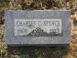
Charles Calen Spence Sr.
| Birth | : | 27 Jun 1869 De Graff, Logan County, Ohio, USA |
| Death | : | 14 Aug 1933 Horton, Brown County, Kansas, USA |
| Burial | : | Wheatland Cemetery, Atchison County, USA |
| Coordinate | : | 39.6453018, -95.5633011 |
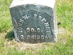
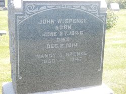
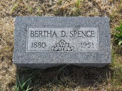
| Description | : | son/o SPENCE, JOHN WILLIAM & NANCY JANE WOLFE. married 1899in Grant co, Ok to Bertha Delores Hook |
frequently asked questions (FAQ):
-
Where is Charles Calen Spence Sr.'s memorial?
Charles Calen Spence Sr.'s memorial is located at: Wheatland Cemetery, Atchison County, USA.
-
When did Charles Calen Spence Sr. death?
Charles Calen Spence Sr. death on 14 Aug 1933 in Horton, Brown County, Kansas, USA
-
Where are the coordinates of the Charles Calen Spence Sr.'s memorial?
Latitude: 39.6453018
Longitude: -95.5633011
Family Members:
Parent
Spouse
Siblings
Children

Flowers:


Nearby Cemetories:
1. Wheatland Cemetery
Atchison County, USA
Coordinate: 39.6453018, -95.5633011
2. Horton Cemetery
Horton, Brown County, USA
Coordinate: 39.6573982, -95.5126419
3. Spring Hill Cemetery
Whiting, Jackson County, USA
Coordinate: 39.6021996, -95.6121979
4. Kennekuk Cemetery
Horton, Brown County, USA
Coordinate: 39.6533012, -95.4875031
5. Saint Leos Catholic Cemetery
Horton, Brown County, USA
Coordinate: 39.6667595, -95.4889603
6. Jessepe Indian Cemetery
Horton, Brown County, USA
Coordinate: 39.6715000, -95.6438000
7. Grant-Mjessepe Cemetery
Horton, Brown County, USA
Coordinate: 39.6663000, -95.6576000
8. Brush Creek Cemetery
Kennekuk, Atchison County, USA
Coordinate: 39.6096992, -95.4702988
9. Lutheran Cemetery
Mercier, Brown County, USA
Coordinate: 39.7250500, -95.6000710
10. Saint Peters Cemetery
Mercier, Brown County, USA
Coordinate: 39.7247009, -95.6016998
11. Wills Cemetery
Muscotah, Atchison County, USA
Coordinate: 39.5596400, -95.5002800
12. Muscotah Cemetery
Muscotah, Atchison County, USA
Coordinate: 39.5539017, -95.5121994
13. Kennekuk Church Cemetery
Horton, Brown County, USA
Coordinate: 39.7074600, -95.6672300
14. All Saints Cemetery
Everest, Brown County, USA
Coordinate: 39.7008018, -95.4507980
15. Carr Cemetery
Everest, Brown County, USA
Coordinate: 39.7254600, -95.4521600
16. Estes Cemetery
Jackson County, USA
Coordinate: 39.5346985, -95.6168976
17. Netawaka Cemetery
Netawaka, Jackson County, USA
Coordinate: 39.6075300, -95.7223700
18. Forest Grove Cemetery
Effingham, Atchison County, USA
Coordinate: 39.5802689, -95.4171524
19. Zion Lutheran Church Cemetery
Everest, Brown County, USA
Coordinate: 39.7290611, -95.4336777
20. Chain Family Cemetery
Huron, Atchison County, USA
Coordinate: 39.6238518, -95.3964767
21. Powhattan Cemetery
Powhattan, Brown County, USA
Coordinate: 39.7681007, -95.6288986
22. Page Cemetery
Brown County, USA
Coordinate: 39.7000600, -95.4015400
23. Claytonville Cemetery
Horton, Brown County, USA
Coordinate: 39.7766991, -95.5046997
24. Thompson-Burns Cemetery
Whiting, Jackson County, USA
Coordinate: 39.5062100, -95.5980710