
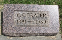
Charles Cornelius “Cordy” Prater
| Birth | : | 15 Dec 1881 Kittitas County, Washington, USA |
| Death | : | 16 Nov 1939 Ellensburg, Kittitas County, Washington, USA |
| Burial | : | St. John the Baptist Churchyard, South Carlton, West Lindsey District, England |
| Coordinate | : | 53.2785000, -0.5754000 |
| Plot | : | 1-14-3 |
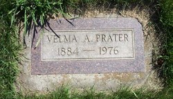
| Description | : | OBIT: C. C. Prater, 57, life-long Kittitas Valley resident and prominent Westside farmer, died here last night at the home of his sister, Mrs. Minnie Wangeman, after an illness of 10 weeks. The son of pioneer valley settlers, he was born on the family farm on the Westside on December 15, 1881. He was married here to Miss Velma Weaver on November 14, 1906. From his youth he took an active part in the activities of the community. Among the many responsibilities which he held at the time of his death were: Community Committeeman of the Kittitas County Conservation Association;... Read More |
frequently asked questions (FAQ):
-
Where is Charles Cornelius “Cordy” Prater's memorial?
Charles Cornelius “Cordy” Prater's memorial is located at: St. John the Baptist Churchyard, South Carlton, West Lindsey District, England.
-
When did Charles Cornelius “Cordy” Prater death?
Charles Cornelius “Cordy” Prater death on 16 Nov 1939 in Ellensburg, Kittitas County, Washington, USA
-
Where are the coordinates of the Charles Cornelius “Cordy” Prater's memorial?
Latitude: 53.2785000
Longitude: -0.5754000
Family Members:
Spouse
Children
Flowers:


Nearby Cemetories:
1. St. John the Baptist Churchyard
South Carlton, West Lindsey District, England
Coordinate: 53.2785000, -0.5754000
2. St. Luke's Churchyard
North Carlton, West Lindsey District, England
Coordinate: 53.2873000, -0.5831200
3. St. Vincent Churchyard
Burton, West Lindsey District, England
Coordinate: 53.2596400, -0.5598100
4. St. John the Baptist Churchyard
Scampton, West Lindsey District, England
Coordinate: 53.3037680, -0.5787140
5. Dam Busters Dog Memorial
Scampton, West Lindsey District, England
Coordinate: 53.3008200, -0.5495800
6. St. Mary's Churchyard
Riseholme, West Lindsey District, England
Coordinate: 53.2688200, -0.5264900
7. St Peter's Churchyard
Aisthorpe, West Lindsey District, England
Coordinate: 53.3102400, -0.5815300
8. St Cuthbert's Churchyard
Brattleby, West Lindsey District, England
Coordinate: 53.3156600, -0.5794750
9. All Saints Churchyard
Broxholme, West Lindsey District, England
Coordinate: 53.2922400, -0.6349600
10. St Nicholas Parish Churchyard
Lincoln, City of Lincoln, England
Coordinate: 53.2400800, -0.5376400
11. Newport Cemetery
Lincoln, City of Lincoln, England
Coordinate: 53.2405150, -0.5362590
12. Saint Mary Magdalene in the Bail Churchyard
Lincoln, City of Lincoln, England
Coordinate: 53.2366000, -0.5402700
13. Lincoln Castle Cemetery
Lincoln, City of Lincoln, England
Coordinate: 53.2342640, -0.5415700
14. St. Michael's Churchyard
Cammeringham, West Lindsey District, England
Coordinate: 53.3275480, -0.5781450
15. Eastgate Cemetery
Lincoln, City of Lincoln, England
Coordinate: 53.2371410, -0.5312100
16. St. Peter in Eastgate Churchyard
Lincoln, City of Lincoln, England
Coordinate: 53.2355350, -0.5335080
17. Woodbank Cemetery
Skellingthorpe, North Kesteven District, England
Coordinate: 53.2375380, -0.6229660
18. Saxilby Cemetery
Saxilby, West Lindsey District, England
Coordinate: 53.2755800, -0.6590400
19. Lincoln Cathedral
Lincoln, City of Lincoln, England
Coordinate: 53.2341805, -0.5363450
20. St. Botolph Churchyard
Saxilby, West Lindsey District, England
Coordinate: 53.2747300, -0.6591000
21. St. Michael on the Mount Churchyard
Lincoln, City of Lincoln, England
Coordinate: 53.2334150, -0.5378640
22. Saint Margaret in the Close Churchyard
Lincoln, City of Lincoln, England
Coordinate: 53.2338310, -0.5352511
23. St. Martin's Churchyard
Lincoln, City of Lincoln, England
Coordinate: 53.2303499, -0.5425414
24. All Saints Churchyard
Nettleham, West Lindsey District, England
Coordinate: 53.2652940, -0.4906780