
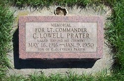
Charles Lowell Prater
| Birth | : | 16 May 1916 Ellensburg, Kittitas County, Washington, USA |
| Death | : | 9 Jan 1950 |
| Burial | : | St. John the Baptist Churchyard, South Carlton, West Lindsey District, England |
| Coordinate | : | 53.2785000, -0.5754000 |
| Plot | : | 1-14-2 |
| Description | : | News-Messenger - Fremont, OH Friday - 13 January 1950 Page 1 - Column 5 CRASH LANDING KILLS TWO WASHINGTON, Jan. 13 - AP- A landing crash on the aircraft carrier Roosevelt Wednesday killed Navy Pilot Charles Lowell Prater, Ellensberg[sic], Wash., and Seaman James Carrabbia, Youngstown, O. Prater's plane caught fire after it crashed, the navy said, burning Carrabbia who was a member of the landing deck crew. -END- |
frequently asked questions (FAQ):
-
Where is Charles Lowell Prater's memorial?
Charles Lowell Prater's memorial is located at: St. John the Baptist Churchyard, South Carlton, West Lindsey District, England.
-
When did Charles Lowell Prater death?
Charles Lowell Prater death on 9 Jan 1950 in
-
Where are the coordinates of the Charles Lowell Prater's memorial?
Latitude: 53.2785000
Longitude: -0.5754000
Family Members:
Parent
Siblings
Flowers:


Nearby Cemetories:
1. St. John the Baptist Churchyard
South Carlton, West Lindsey District, England
Coordinate: 53.2785000, -0.5754000
2. St. Luke's Churchyard
North Carlton, West Lindsey District, England
Coordinate: 53.2873000, -0.5831200
3. St. Vincent Churchyard
Burton, West Lindsey District, England
Coordinate: 53.2596400, -0.5598100
4. St. John the Baptist Churchyard
Scampton, West Lindsey District, England
Coordinate: 53.3037680, -0.5787140
5. Dam Busters Dog Memorial
Scampton, West Lindsey District, England
Coordinate: 53.3008200, -0.5495800
6. St. Mary's Churchyard
Riseholme, West Lindsey District, England
Coordinate: 53.2688200, -0.5264900
7. St Peter's Churchyard
Aisthorpe, West Lindsey District, England
Coordinate: 53.3102400, -0.5815300
8. St Cuthbert's Churchyard
Brattleby, West Lindsey District, England
Coordinate: 53.3156600, -0.5794750
9. All Saints Churchyard
Broxholme, West Lindsey District, England
Coordinate: 53.2922400, -0.6349600
10. St Nicholas Parish Churchyard
Lincoln, City of Lincoln, England
Coordinate: 53.2400800, -0.5376400
11. Newport Cemetery
Lincoln, City of Lincoln, England
Coordinate: 53.2405150, -0.5362590
12. Saint Mary Magdalene in the Bail Churchyard
Lincoln, City of Lincoln, England
Coordinate: 53.2366000, -0.5402700
13. Lincoln Castle Cemetery
Lincoln, City of Lincoln, England
Coordinate: 53.2342640, -0.5415700
14. St. Michael's Churchyard
Cammeringham, West Lindsey District, England
Coordinate: 53.3275480, -0.5781450
15. Eastgate Cemetery
Lincoln, City of Lincoln, England
Coordinate: 53.2371410, -0.5312100
16. St. Peter in Eastgate Churchyard
Lincoln, City of Lincoln, England
Coordinate: 53.2355350, -0.5335080
17. Woodbank Cemetery
Skellingthorpe, North Kesteven District, England
Coordinate: 53.2375380, -0.6229660
18. Saxilby Cemetery
Saxilby, West Lindsey District, England
Coordinate: 53.2755800, -0.6590400
19. Lincoln Cathedral
Lincoln, City of Lincoln, England
Coordinate: 53.2341805, -0.5363450
20. St. Botolph Churchyard
Saxilby, West Lindsey District, England
Coordinate: 53.2747300, -0.6591000
21. St. Michael on the Mount Churchyard
Lincoln, City of Lincoln, England
Coordinate: 53.2334150, -0.5378640
22. Saint Margaret in the Close Churchyard
Lincoln, City of Lincoln, England
Coordinate: 53.2338310, -0.5352511
23. St. Martin's Churchyard
Lincoln, City of Lincoln, England
Coordinate: 53.2303499, -0.5425414
24. All Saints Churchyard
Nettleham, West Lindsey District, England
Coordinate: 53.2652940, -0.4906780