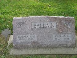
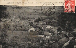
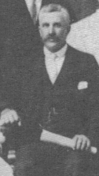
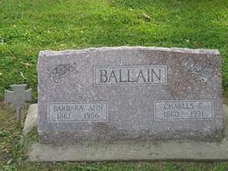
Charles Emile Ballain
| Birth | : | 1 Jan 1860 Audeloncourt, Departement de la Haute-Marne, Champagne-Ardenne, France |
| Death | : | 28 Apr 1931 Malvern, Mills County, Iowa, USA |
| Burial | : | Surteby Kyrkogård, Surteby, Marks kommun, Sweden |
| Coordinate | : | 57.4415428, 12.5166545 |
| Plot | : | #189 |
| Description | : | Malvern Leader, May 7, 1931, page 4 Charles Emil Ballain Funeral services for Charles Emil Ballain. mention of whose death was made in last week's Leader, were held in the Methodist church in Emerson Friday afternoon at 2 o'clock. The church was filled to overflowing with relatives, old friends and acquaintances for he was well and widely known. Many were in attendance from Malvern, Tabor, Red Oak, Hastings, and other surrounding towns as well as some from a greater distance. Rev. M. B. Wilson, pastor of the Methodist church, had charge of the services and preached a touching... Read More |
frequently asked questions (FAQ):
-
Where is Charles Emile Ballain's memorial?
Charles Emile Ballain's memorial is located at: Surteby Kyrkogård, Surteby, Marks kommun, Sweden.
-
When did Charles Emile Ballain death?
Charles Emile Ballain death on 28 Apr 1931 in Malvern, Mills County, Iowa, USA
-
Where are the coordinates of the Charles Emile Ballain's memorial?
Latitude: 57.4415428
Longitude: 12.5166545
Family Members:
Parent
Spouse
Siblings
Children
Flowers:
Nearby Cemetories:
1. Surteby Kyrkogård
Surteby, Marks kommun, Sweden
Coordinate: 57.4415428, 12.5166545
2. Kattunga Kyrkogård
Kattunga, Marks kommun, Sweden
Coordinate: 57.4103879, 12.5360568
3. Berghems Kyrkogård
Berghem, Marks kommun, Sweden
Coordinate: 57.4618151, 12.5881601
4. Hajoms Kyrkogård
Hajom, Marks kommun, Sweden
Coordinate: 57.5039644, 12.5509172
5. Orby Kyrkogard
Örby, Marks kommun, Sweden
Coordinate: 57.4818140, 12.7005510
6. Idala kyrkogard
Idala, Kungsbacka kommun, Sweden
Coordinate: 57.3807920, 12.3236715
7. Fritsla gamla kyrkogård
Fritsla, Marks kommun, Sweden
Coordinate: 57.5574232, 12.7928255
8. Skephult kyrkogård
Skepphult, Marks kommun, Sweden
Coordinate: 57.5361110, 12.8811110
9. Bollebygd Cemetery
Bollebygd, Bollebygds kommun, Sweden
Coordinate: 57.6666679, 12.5500002
10. Onsala Kyrkogård
Kungsbacka kommun, Sweden
Coordinate: 57.4132398, 12.0226945
11. Kållered kyrka
Kallered, Mölndals kommun, Sweden
Coordinate: 57.6060222, 12.0556331
12. Rolfstorps Kyrkogård
Himle, Varbergs kommun, Sweden
Coordinate: 57.1437882, 12.4673786
13. Mårdaklevs Gamla Kyrkogård
Mardaklev, Svenljunga kommun, Sweden
Coordinate: 57.2589286, 12.9950129
14. Billdals kyrkogård
Billdal, Göteborgs kommun, Sweden
Coordinate: 57.5805229, 11.9794241
15. Kikås Cemetery
Mölndals kommun, Sweden
Coordinate: 57.6489610, 12.0472210
16. Svenska Kyrkan
Svenljunga, Svenljunga kommun, Sweden
Coordinate: 57.4951300, 13.1159100
17. Ljushults Kyrkogård
Borås, Borås kommun, Sweden
Coordinate: 57.6174795, 13.0432013
18. Sankt Sigfrids griftegård
Borås, Borås kommun, Sweden
Coordinate: 57.7049706, 12.9184835
19. Jonsereds griftegård
Jonsered, Partille kommun, Sweden
Coordinate: 57.7420182, 12.1762995
20. Sankta Birgittas griftegård
Borås, Borås kommun, Sweden
Coordinate: 57.7142538, 12.9332699
21. Kvastekulla Griftegård
Partille, Partille kommun, Sweden
Coordinate: 57.7337760, 12.1428190
22. Askims Södra kyrkogård
Hovas, Göteborgs kommun, Sweden
Coordinate: 57.6157113, 11.9416889
23. Sankt Ansgars griftegård
Borås, Borås kommun, Sweden
Coordinate: 57.7182057, 12.9351487
24. Lerums gamla kyrkogård
Lerums kommun, Sweden
Coordinate: 57.7757400, 12.2826970

