
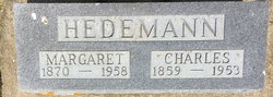
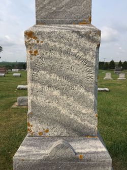
Charles Friedrick Gerhardt Hedemann
| Birth | : | 25 Sep 1859 Clayton County, Iowa, USA |
| Death | : | 18 Jan 1953 Clayton County, Iowa, USA |
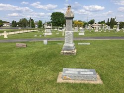
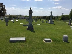
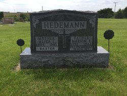
| Burial | : | Garnavillo Community Cemetery, Garnavillo, Clayton County, USA |
| Coordinate | : | 42.8656000, -91.2422100 |
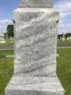
| Description | : | Biography of Charles and Margaret Mohning Hedemann by Joyce Hedemann 1984 History of Clayton County; p. 321 Charles Friedrick Gerhardt Hedemann b. Sept 25, 1859, to Friedrich and Helena Bruns Hedemann in a log cabin on the Hedemann farm two miles north of Garnavillo. He was the youngest of six children. Margaret Katharina Mohning b. March 8, 1870, to Herman and Maria Pefmeier on a farm near Garnavillo. There were six other children in the Mohning family: Anna, Lena, Sophia, John, Henry, and Fred. Charles Hedemann and Margaret Mohning were married Jan. 17, 1887. They made... Read More |
frequently asked questions (FAQ):
-
Where is Charles Friedrick Gerhardt Hedemann's memorial?
Charles Friedrick Gerhardt Hedemann's memorial is located at: Garnavillo Community Cemetery, Garnavillo, Clayton County, USA.
-
When did Charles Friedrick Gerhardt Hedemann death?
Charles Friedrick Gerhardt Hedemann death on 18 Jan 1953 in Clayton County, Iowa, USA
-
Where are the coordinates of the Charles Friedrick Gerhardt Hedemann's memorial?
Latitude: 42.8656000
Longitude: -91.2422100
Family Members:
Parent
Spouse

Siblings

Children
Flowers:


Nearby Cemetories:
1. Garnavillo Community Cemetery
Garnavillo, Clayton County, USA
Coordinate: 42.8656000, -91.2422100
2. Garnavillo Cemetery
Garnavillo, Clayton County, USA
Coordinate: 42.8660300, -91.2390100
3. Saint Joseph Cemetery
Garnavillo, Clayton County, USA
Coordinate: 42.8628006, -91.2502975
4. McClelland Cemetery
Garnavillo, Clayton County, USA
Coordinate: 42.8249879, -91.2084641
5. Pioneer Rock Cemetery
Ceres, Clayton County, USA
Coordinate: 42.8230591, -91.1863937
6. Clayton Center Cemetery
Clayton Center, Clayton County, USA
Coordinate: 42.8841705, -91.3225021
7. Zion Lutheran Cemetery
Clayton Center, Clayton County, USA
Coordinate: 42.8841705, -91.3249969
8. Clayton Cemetery
Clayton, Clayton County, USA
Coordinate: 42.9043999, -91.1641998
9. Tangeman Family Cemetery
Garnavillo, Clayton County, USA
Coordinate: 42.8580000, -91.1420000
10. Saint Michael Cemetery
Clayton County, USA
Coordinate: 42.8055992, -91.1802979
11. County Home Cemetery
Clayton Center, Clayton County, USA
Coordinate: 42.8916702, -91.3499985
12. Krumm Cemetery
Garber, Clayton County, USA
Coordinate: 42.7913760, -91.3023559
13. Colony Catholic Cemetery (Defunct)
Read Township, Clayton County, USA
Coordinate: 42.8830000, -91.3580000
14. Borcherding Cemetery
Jefferson Township, Clayton County, USA
Coordinate: 42.8182983, -91.1414032
15. National Cemetery
National, Clayton County, USA
Coordinate: 42.9536018, -91.2902985
16. Storck Cemetery
Guttenberg, Clayton County, USA
Coordinate: 42.7694335, -91.1834638
17. Harford Cemetery
Wyalusing, Grant County, USA
Coordinate: 42.9401000, -91.1401800
18. Saint Paula Cemetery
Osterdock, Clayton County, USA
Coordinate: 42.7635994, -91.1992035
19. Meenan Cemetery
Communia, Clayton County, USA
Coordinate: 42.7999862, -91.3584693
20. Norwegian Church Cemetery
McGregor, Clayton County, USA
Coordinate: 42.9644400, -91.1764100
21. Old Garber Cemetery
Garber, Clayton County, USA
Coordinate: 42.7560005, -91.2580032
22. Elkader Cemetery
Elkader, Clayton County, USA
Coordinate: 42.8541718, -91.4000015
23. Bagley Cemetery
Bagley, Grant County, USA
Coordinate: 42.9019012, -91.0907974
24. First Evangelical Lutheran Church Cemetery
McGregor, Clayton County, USA
Coordinate: 42.9718000, -91.1760000