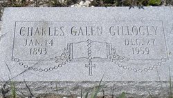
Charles Galen “Jack” Gillogly
| Birth | : | 14 Jan 1893 Townsend, Broadwater County, Montana, USA |
| Death | : | 27 Dec 1959 Townsend, Broadwater County, Montana, USA |
| Burial | : | Saint Johns Episcopal Church Resurrection Garden, Royal Oak, Oakland County, USA |
| Coordinate | : | 42.4892970, -83.1574120 |
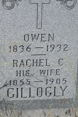
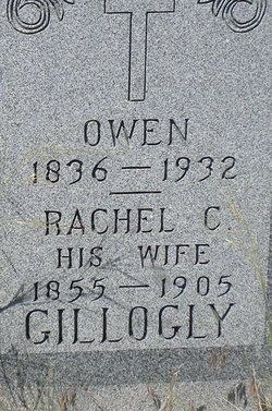
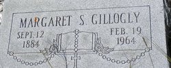
| Description | : | Montana Standard, Butte, MT, 29 Dec 1959 Townsend Rancher Dies Charles Galen (Jack) Gillogly, 66, native of Townsend and Fort Logan area rancher for many years, died Sunday at the Broadwater Hospital following a brief illness. Mr. Gillogly was born Jan. 14, 1893, in Townsend, the son of Owen and Rachael Gillogly. In 1941 he retired from ranching in the Fort Logan area and moved to Townsend to make his home. Survivors include a sister, Margaret Gillogly, and a brother, Hugh Gillogly, both of Townsend. Funeral services at Holy Cross church in Townsend. Burial in Canton cemetery, Townsend. |
frequently asked questions (FAQ):
-
Where is Charles Galen “Jack” Gillogly's memorial?
Charles Galen “Jack” Gillogly's memorial is located at: Saint Johns Episcopal Church Resurrection Garden, Royal Oak, Oakland County, USA.
-
When did Charles Galen “Jack” Gillogly death?
Charles Galen “Jack” Gillogly death on 27 Dec 1959 in Townsend, Broadwater County, Montana, USA
-
Where are the coordinates of the Charles Galen “Jack” Gillogly's memorial?
Latitude: 42.4892970
Longitude: -83.1574120
Family Members:
Parent
Siblings
Flowers:
Nearby Cemetories:
1. Saint Johns Episcopal Church Resurrection Garden
Royal Oak, Oakland County, USA
Coordinate: 42.4892970, -83.1574120
2. Saint Marys Cemetery
Royal Oak, Oakland County, USA
Coordinate: 42.5002430, -83.1444560
3. Royal Oak Cemetery
Royal Oak, Oakland County, USA
Coordinate: 42.5036011, -83.1442032
4. Oakview Cemetery
Royal Oak, Oakland County, USA
Coordinate: 42.5005989, -83.1393967
5. Roseland Park Cemetery
Berkley, Oakland County, USA
Coordinate: 42.5060997, -83.1797028
6. Congregation Beth Tefilo Cemetery
Ferndale, Oakland County, USA
Coordinate: 42.4536819, -83.1303940
7. Saint David Episcopal Church Columbarium
Southfield, Oakland County, USA
Coordinate: 42.5030990, -83.2096400
8. Machpelah Cemetery
Ferndale, Oakland County, USA
Coordinate: 42.4525470, -83.1295570
9. Beth Abraham Cemetery
Ferndale, Oakland County, USA
Coordinate: 42.4508290, -83.1285990
10. Saint Andrews Memorial Garden
Clawson, Oakland County, USA
Coordinate: 42.5359612, -83.1460571
11. Beekman Cemetery
Southfield, Oakland County, USA
Coordinate: 42.5098076, -83.2176285
12. Woodlawn Cemetery
Detroit, Wayne County, USA
Coordinate: 42.4430962, -83.1277542
13. Clover Hill Park Cemetery
Birmingham, Oakland County, USA
Coordinate: 42.5349998, -83.1885986
14. Perrin Cemetery
Troy, Oakland County, USA
Coordinate: 42.5398254, -83.1857605
15. Acacia Park Cemetery
Beverly Hills, Oakland County, USA
Coordinate: 42.5217018, -83.2197037
16. Evergreen Cemetery
Detroit, Wayne County, USA
Coordinate: 42.4384710, -83.1206700
17. Southfield Reformed Cemetery
Southfield, Oakland County, USA
Coordinate: 42.4848420, -83.2405580
18. Dun Scotus - Franciscan Catholic Cemetery
Southfield, Oakland County, USA
Coordinate: 42.4609690, -83.2437940
19. Saint James Episcopal Church Columbarium
Birmingham, Oakland County, USA
Coordinate: 42.5465088, -83.2179642
20. Detroit Memorial Park East
Warren, Macomb County, USA
Coordinate: 42.5196880, -83.0644300
21. Pioneer Cemetery
Southfield, Oakland County, USA
Coordinate: 42.4749140, -83.2603170
22. Southfield Cemetery
Southfield, Oakland County, USA
Coordinate: 42.4749985, -83.2608032
23. Holy Trinity Cemetery
Sterling Heights, Macomb County, USA
Coordinate: 42.5461006, -83.0830994
24. First United Methodist Church Memorial Garden
Birmingham, Oakland County, USA
Coordinate: 42.5454370, -83.2330870

