
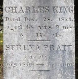

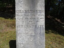
Charles King
| Birth | : | 11 Mar 1803 Sutton, Worcester County, Massachusetts, USA |
| Death | : | 28 Dec 1871 Anoka, Anoka County, Minnesota, USA |
| Burial | : | Whitstable Cemetery, Whitstable, City of Canterbury, England |
| Coordinate | : | 51.3529870, 1.0338530 |
| Plot | : | Section 1 (on 2010 Cox sectional plan) |
| Description | : | Son of Isaac & Sarah/Sally (Putnam) King. He and Serena Pratt married in Sutton on Augutst 29, 1824. Sons Elias Pratt King (1825) and Charles Edward (1841) were born in Sutton. In the King genealogy section on Pg. 681 of the History of Sutton, 1704-1876, it states Charles and Serena "removed to Anoka, Minn." No death record for Charles King has been located. However, he and Serena are living in Anoka, MN, in the 1860 census (farmer and housekeeper) and the 1870 census (disabled and housekeeper). Also, there is a 1903 Anoka, MN, death record for Serena King. |
frequently asked questions (FAQ):
-
Where is Charles King's memorial?
Charles King's memorial is located at: Whitstable Cemetery, Whitstable, City of Canterbury, England.
-
When did Charles King death?
Charles King death on 28 Dec 1871 in Anoka, Anoka County, Minnesota, USA
-
Where are the coordinates of the Charles King's memorial?
Latitude: 51.3529870
Longitude: 1.0338530
Family Members:
Parent

Spouse
Siblings

Children

Flowers:


Nearby Cemetories:
1. All Saints Churchyard
Whitstable, City of Canterbury, England
Coordinate: 51.3558090, 1.0396670
2. St Alphege Churchyard
Whitstable, City of Canterbury, England
Coordinate: 51.3576330, 1.0251080
3. St. Alphege's Churchyard
Seasalter, City of Canterbury, England
Coordinate: 51.3432041, 1.0041740
4. St John the Baptist Churchyard
Swalecliffe, City of Canterbury, England
Coordinate: 51.3645500, 1.0667200
5. St Cosmus and St Damian Churchyard
Blean, City of Canterbury, England
Coordinate: 51.3052720, 1.0530480
6. Herne Bay Cemetery
Herne Bay, City of Canterbury, England
Coordinate: 51.3571810, 1.1304820
7. All Saints Churchyard
Graveney, Swale Borough, England
Coordinate: 51.3261450, 0.9447880
8. St Martins
Herne, City of Canterbury, England
Coordinate: 51.3500600, 1.1333200
9. St Martin's Churchyard
Herne, City of Canterbury, England
Coordinate: 51.3497060, 1.1334370
10. St Michael Churchyard
Hernhill, Swale Borough, England
Coordinate: 51.3077430, 0.9612050
11. Canterbury City Cemetery
Canterbury, City of Canterbury, England
Coordinate: 51.2843285, 1.0637640
12. St Nicholas Hospital Church
Harbledown, City of Canterbury, England
Coordinate: 51.2828200, 1.0536580
13. Christ Church Churchyard
Dunkirk, Swale Borough, England
Coordinate: 51.2916540, 0.9741890
14. St Michael and All Angels Church
Harbledown, City of Canterbury, England
Coordinate: 51.2824590, 1.0556800
15. Canterbury Jewish Cemetery
Canterbury, City of Canterbury, England
Coordinate: 51.2846135, 1.0706660
16. St. Dunstan Churchyard
Canterbury, City of Canterbury, England
Coordinate: 51.2836820, 1.0707800
17. St Bartholomew Churchyard
Goodnestone, Dover District, England
Coordinate: 51.3166220, 0.9322200
18. Sturry Cemetery
Sturry, City of Canterbury, England
Coordinate: 51.3058100, 1.1277700
19. St. John the Baptist Hospital Chapelyard
Canterbury, City of Canterbury, England
Coordinate: 51.2832713, 1.0837677
20. Holy Cross Church
Canterbury, City of Canterbury, England
Coordinate: 51.2811350, 1.0755710
21. St Nicholas Churchyard
Sturry, City of Canterbury, England
Coordinate: 51.2984830, 1.1201330
22. Westgate Gardens
Canterbury, City of Canterbury, England
Coordinate: 51.2805250, 1.0745040
23. St Gregory's Priory (defunct)
Canterbury, City of Canterbury, England
Coordinate: 51.2831127, 1.0855358
24. St Peter the Apostle Churchyard
Canterbury, City of Canterbury, England
Coordinate: 51.2807260, 1.0775370