
| Birth | : | 5 Oct 1868 Miller County, Missouri, USA |
| Death | : | 22 Oct 1941 Miller County, Missouri, USA |
| Burial | : | Mount Pleasant Cemetery, Eldon, Miller County, USA |
| Coordinate | : | 38.3667700, -92.5300800 |
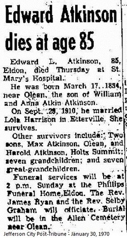
| Description | : | Unknown Newspaper, October 1941 Charles Taylor Atkinson, son of William and Anna Atkinson, was born October 5, 1868, and departed this life October 22, 1941, at the age of 73 years and 17 days. At an early age he was converted to the Christian faith and united with the Mt. Pleasant Christian Church, where his membership remained until his death. Mr. Atkinson was a patient sufferer for nearly four years, always cheerful until the last several months and did not complain of his suffering although at times it was intense. During his life he spent several years in the... Read More |
frequently asked questions (FAQ):
-
Where is Charles Taylor Atkinson's memorial?
Charles Taylor Atkinson's memorial is located at: Mount Pleasant Cemetery, Eldon, Miller County, USA.
-
When did Charles Taylor Atkinson death?
Charles Taylor Atkinson death on 22 Oct 1941 in Miller County, Missouri, USA
-
Where are the coordinates of the Charles Taylor Atkinson's memorial?
Latitude: 38.3667700
Longitude: -92.5300800
Family Members:
Parent

Siblings
Flowers:


Nearby Cemetories:
1. Mount Pleasant Cemetery
Eldon, Miller County, USA
Coordinate: 38.3667700, -92.5300800
2. Mount Vernon Cemetery
Eldon, Miller County, USA
Coordinate: 38.3624992, -92.5606003
3. Salem Cemetery
Saline Township, Miller County, USA
Coordinate: 38.3691232, -92.5697260
4. Salem Cemetery
Eldon, Miller County, USA
Coordinate: 38.3697014, -92.5714035
5. Eldon Cemetery
Eldon, Miller County, USA
Coordinate: 38.3642006, -92.5868988
6. Olean Cemetery
Olean, Miller County, USA
Coordinate: 38.4131012, -92.5413971
7. Green Ridge Baptist Church Cemetery
Eldon, Miller County, USA
Coordinate: 38.4116200, -92.5645700
8. Allen Cemetery
Olean, Miller County, USA
Coordinate: 38.4150009, -92.5008011
9. Hite Cemetery
Miller County, USA
Coordinate: 38.4039001, -92.5935974
10. Etter-Walker Cemetery
Burris Fork, Moniteau County, USA
Coordinate: 38.4333700, -92.5525400
11. Walker Cemetery
Moniteau County, USA
Coordinate: 38.4338989, -92.5522003
12. Farris Cemetery
Moniteau County, USA
Coordinate: 38.4369900, -92.5380000
13. Artz-Wenzel Cemetery
Eldon, Miller County, USA
Coordinate: 38.2980995, -92.5622025
14. Jackson Chapel Methodist Church Cemetery
California, Moniteau County, USA
Coordinate: 38.4447900, -92.5286500
15. Taylor Cemetery
Eldon, Miller County, USA
Coordinate: 38.3443985, -92.6303024
16. Harbison-Russell Cemetery
Miller County, USA
Coordinate: 38.2990000, -92.4633500
17. Skinner Cemetery
Miller County, USA
Coordinate: 38.2806015, -92.5481033
18. Gray Cemetery
Moniteau County, USA
Coordinate: 38.4536018, -92.5456009
19. Gageville Cemetery
Miller County, USA
Coordinate: 38.3161011, -92.4330978
20. Dooley Cemetery
Eldon, Miller County, USA
Coordinate: 38.3191400, -92.6353500
21. Colburn Cemetery
Eldon, Miller County, USA
Coordinate: 38.4246300, -92.6275500
22. Spring Garden Cemetery
Spring Garden, Miller County, USA
Coordinate: 38.3922005, -92.4111023
23. Phillips Cemetery
High Point, Moniteau County, USA
Coordinate: 38.4430300, -92.6125300
24. Bruce-Lewis-McGahan Cemetery
Enon, Moniteau County, USA
Coordinate: 38.4667500, -92.5172100