
| Birth | : | 2 Feb 1875 Miller County, Missouri, USA |
| Death | : | 8 Apr 1921 Jefferson City, Cole County, Missouri, USA |
| Burial | : | Spring Garden Cemetery, Spring Garden, Miller County, USA |
| Coordinate | : | 38.3922005, -92.4111023 |
| Description | : | Jefferson City Daily Capital News Sunday, April 10, 1921, Jefferson City, Missouri, United States Of America Mrs. Lottie Bond, of Enon, died at St. Mary's Hospital Friday night after a long illness of cancer. She was 46 years of age. Mrs. Bond was born in Miller County and resided there practically all her life. Besides her husband she is mourned by one sister, Mrs. Buck Russell, of Eldon, and six brothers. The funeral will take place at Spring Garden today. obituary contributed by Deb Cooper |
frequently asked questions (FAQ):
-
Where is Lottie Atkinson Bond's memorial?
Lottie Atkinson Bond's memorial is located at: Spring Garden Cemetery, Spring Garden, Miller County, USA.
-
When did Lottie Atkinson Bond death?
Lottie Atkinson Bond death on 8 Apr 1921 in Jefferson City, Cole County, Missouri, USA
-
Where are the coordinates of the Lottie Atkinson Bond's memorial?
Latitude: 38.3922005
Longitude: -92.4111023
Family Members:
Parent

Spouse
Siblings
Flowers:


Nearby Cemetories:
1. Spring Garden Cemetery
Spring Garden, Miller County, USA
Coordinate: 38.3922005, -92.4111023
2. Farmer Cemetery
Hickory Hill, Cole County, USA
Coordinate: 38.4143500, -92.3889790
3. Hickory Hill Cemetery
Hickory Hill, Cole County, USA
Coordinate: 38.4005900, -92.3596300
4. Duncan-Berry Family Cemetery
Eugene, Cole County, USA
Coordinate: 38.4255555, -92.3761111
5. Eugene Cemetery
Eugene, Cole County, USA
Coordinate: 38.3502900, -92.3946100
6. Bethel Cemetery
Hickory Hill, Cole County, USA
Coordinate: 38.4122400, -92.3465900
7. Mount Carmel Cemetery
Brazito, Cole County, USA
Coordinate: 38.4398499, -92.3734207
8. Helton Farm Burial Ground
Hickory Hill, Cole County, USA
Coordinate: 38.4288500, -92.3464100
9. Matheis Cemetery
Russellville, Cole County, USA
Coordinate: 38.4571800, -92.4491600
10. Fowler Farm Burial Ground
Bass, Cole County, USA
Coordinate: 38.4193750, -92.3235020
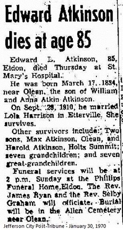
11. Allen Cemetery
Olean, Miller County, USA
Coordinate: 38.4150009, -92.5008011
12. Henley Cemetery
Henley, Cole County, USA
Coordinate: 38.3907200, -92.3164800
13. Gageville Cemetery
Miller County, USA
Coordinate: 38.3161011, -92.4330978
14. Roark Cemetery
Russellville, Cole County, USA
Coordinate: 38.4696999, -92.4255981
15. Raithel Cemetery
Brazito, Cole County, USA
Coordinate: 38.4420300, -92.3272400
16. Clibourn Cemetery
Russellville, Cole County, USA
Coordinate: 38.4760500, -92.3973500
17. Campbell Cemetery
Cole County, USA
Coordinate: 38.4810982, -92.4297028
18. Jenkins-Bungart Cemetery
Marys Home, Miller County, USA
Coordinate: 38.3133011, -92.3480988
19. Mount Pleasant Cemetery
Eldon, Miller County, USA
Coordinate: 38.3667700, -92.5300800
20. Our Lady of the Snows Cemetery
Marys Home, Miller County, USA
Coordinate: 38.3038440, -92.3567560
21. Rush Chapel Cemetery
Miller County, USA
Coordinate: 38.2950600, -92.3902100
22. Friedens Cemetery
Brazito, Cole County, USA
Coordinate: 38.4446182, -92.3035660
23. Harbison-Russell Cemetery
Miller County, USA
Coordinate: 38.2990000, -92.4633500
24. Arnhold Burial Ground
Brazito, Cole County, USA
Coordinate: 38.4478370, -92.3005870