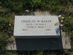
Charles William Baker
| Birth | : | 26 Jul 1894 Doland, Spink County, South Dakota, USA |
| Death | : | 25 Apr 1984 Philip, Haakon County, South Dakota, USA |
| Burial | : | Mosswood Cemetery, Cotuit, Barnstable County, USA |
| Coordinate | : | 41.6279984, -70.4303970 |
| Plot | : | G-4 |
| Inscription | : | SEA2 US NAVY WORLD WAR 1 |
| Description | : | Charles Baker and his family lived in Doland, Turton, Raymond and Clark, SD until 1918 when they moved to Melette County near White River. In March 1941, he came to Philip, where he was County Supervisor for the Farm Security Administration. In 1954, he resigned that position and became Haakon County Treasurer, then Auditor, and finally Haakon County Veteran's Service Officer. |
frequently asked questions (FAQ):
-
Where is Charles William Baker's memorial?
Charles William Baker's memorial is located at: Mosswood Cemetery, Cotuit, Barnstable County, USA.
-
When did Charles William Baker death?
Charles William Baker death on 25 Apr 1984 in Philip, Haakon County, South Dakota, USA
-
Where are the coordinates of the Charles William Baker's memorial?
Latitude: 41.6279984
Longitude: -70.4303970
Family Members:
Parent
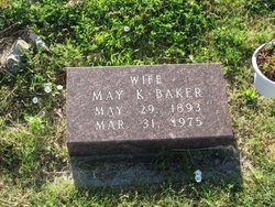
Spouse
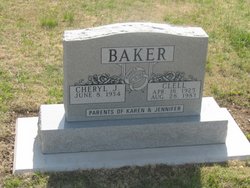
Children
Flowers:
Nearby Cemetories:
1. Mosswood Cemetery
Cotuit, Barnstable County, USA
Coordinate: 41.6279984, -70.4303970
2. Coombs Cemetery
Mashpee, Barnstable County, USA
Coordinate: 41.6417370, -70.4570980
3. Mashpee Town Cemetery
Mashpee, Barnstable County, USA
Coordinate: 41.6242981, -70.4787979
4. Marstons Mills Cemetery
Marstons Mills, Barnstable County, USA
Coordinate: 41.6612015, -70.4080963
5. Hillside Cemetery
Osterville, Barnstable County, USA
Coordinate: 41.6316700, -70.3787100
6. Saint Peters Episcopal Church Memorial Garden
Barnstable, Barnstable County, USA
Coordinate: 41.6209700, -70.3735800
7. Lakewood Cemetery
Mashpee, Barnstable County, USA
Coordinate: 41.6530991, -70.4783020
8. Great Neck Woods Cemetery
Mashpee, Barnstable County, USA
Coordinate: 41.6054000, -70.4835600
9. Attaquin Cemetery
Mashpee, Barnstable County, USA
Coordinate: 41.6517296, -70.4883881
10. Wakeby Cemetery
Sandwich, Barnstable County, USA
Coordinate: 41.6725500, -70.4723100
11. Boardley Road Cemetery
Sandwich, Barnstable County, USA
Coordinate: 41.6870003, -70.4559021
12. Percival Cemetery
Sandwich, Barnstable County, USA
Coordinate: 41.6883011, -70.4557037
13. Francis Family Cemetery
Mashpee, Barnstable County, USA
Coordinate: 41.6807900, -70.4816600
14. Congregational Cemetery
Barnstable, Barnstable County, USA
Coordinate: 41.6459007, -70.3461990
15. Beechwood Cemetery
Centerville, Barnstable County, USA
Coordinate: 41.6561012, -70.3491974
16. Centerville Ancient Cemetery
Centerville, Barnstable County, USA
Coordinate: 41.6547012, -70.3429031
17. Animal Inn Pet Cemetery
Forestdale, Barnstable County, USA
Coordinate: 41.6754200, -70.5070100
18. Saint Francis Xavier Cemetery
Centerville, Barnstable County, USA
Coordinate: 41.6516991, -70.3331985
19. Crocker Park Cemetery
Barnstable, Barnstable County, USA
Coordinate: 41.6959000, -70.3780975
20. West Parish Burial Ground
West Barnstable, Barnstable County, USA
Coordinate: 41.6984200, -70.3842920
21. Tobey Cemetery
Forestdale, Barnstable County, USA
Coordinate: 41.6972008, -70.4875031
22. Forestdale Cemetery
Forestdale, Barnstable County, USA
Coordinate: 41.6903000, -70.5024033
23. Bay View Cemetery
Waquoit Village, Barnstable County, USA
Coordinate: 41.5815720, -70.5268460
24. West Barnstable Cemetery
West Barnstable, Barnstable County, USA
Coordinate: 41.7080994, -70.3728027


