

Charlotte S Lanier Bennett
| Birth | : | unknown Lancaster County, South Carolina, USA |
| Death | : | unknown South Carolina, USA |
| Burial | : | Old Six Mile Cemetery, Indian Land, Lancaster County, USA |
| Coordinate | : | 34.9484250, -80.8220320 |
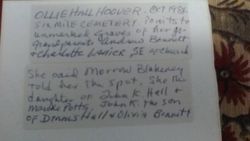
| Description | : | October 1984 Ollie Hall Hoover went to the Old Six Mile Cemetery and pointed to the unmarked graves of her great grandparents Andrew Bennett and Charlotte Lanier, SE of the Church. Sarah J Morrow Blakeney Burleyson had told Ollie about the graves. Sarah the daughter of Sarah Morrow and John Coffey. Charlotte Lanier the daughter of Herbert Lanier and Harriet Moore. This information from the records of Lindsey Pettus Archives. |
frequently asked questions (FAQ):
-
Where is Charlotte S Lanier Bennett's memorial?
Charlotte S Lanier Bennett's memorial is located at: Old Six Mile Cemetery, Indian Land, Lancaster County, USA.
-
When did Charlotte S Lanier Bennett death?
Charlotte S Lanier Bennett death on unknown in South Carolina, USA
-
Where are the coordinates of the Charlotte S Lanier Bennett's memorial?
Latitude: 34.9484250
Longitude: -80.8220320
Family Members:
Spouse

Children
Flowers:


Nearby Cemetories:
1. Old Six Mile Cemetery
Indian Land, Lancaster County, USA
Coordinate: 34.9484250, -80.8220320
2. Elbethel AME Zion Church Cemetery
Belair, Lancaster County, USA
Coordinate: 34.9626270, -80.8299860
3. Old Elbethel AME Zion Church Cemetery
Indian Land, Lancaster County, USA
Coordinate: 34.9631250, -80.8125350
4. Belair Methodist Church Cemetery
Lancaster County, USA
Coordinate: 34.9509964, -80.8433228
5. Six Mile Cemetery
Indian Land, Lancaster County, USA
Coordinate: 34.9308014, -80.8319016
6. Indian Land Baptist Church Cemetery
Indian Land, Lancaster County, USA
Coordinate: 34.9318840, -80.8367260
7. Center Grove Memorial Park
Indian Land, Lancaster County, USA
Coordinate: 34.9205500, -80.8122100
8. Our Lady of Grace Catholic Church Cemetery
Indian Land, Lancaster County, USA
Coordinate: 34.9191510, -80.7933580
9. Higher Ground Church Cemetery
Indian Land, Lancaster County, USA
Coordinate: 34.9713300, -80.8597020
10. Edwards Cemetery
Indian Land, Lancaster County, USA
Coordinate: 34.9770010, -80.8607570
11. Osceola United Methodist Church Cemetery
Lancaster, Lancaster County, USA
Coordinate: 34.9056920, -80.8091770
12. Gold Hill AME Zion Church Cemetery
Van Wyck, Lancaster County, USA
Coordinate: 34.9094340, -80.8472940
13. Banks Presbyterian Church Cemetery
Marvin, Union County, USA
Coordinate: 34.9930305, -80.8189697
14. Marvin United Methodist Church Cemetery
Marvin, Union County, USA
Coordinate: 34.9928894, -80.8166580
15. Marvin AME Zion Church Cemetery
Waxhaw, Union County, USA
Coordinate: 34.9920000, -80.8040000
16. Bonds Grove United Methodist Church Cemetery
Waxhaw, Union County, USA
Coordinate: 34.9739609, -80.7715378
17. Price Chapel Baptist Church Cemetery
Waxhaw, Union County, USA
Coordinate: 34.9415283, -80.7617188
18. Pleasant Valley Baptist Church Cemetery
Lancaster County, USA
Coordinate: 34.9931793, -80.8495407
19. Providence Baptist Church Cemetery
Waxhaw, Union County, USA
Coordinate: 34.9441200, -80.7547200
20. Macedonia Baptist Church
Indian Land, Lancaster County, USA
Coordinate: 34.8975580, -80.8555820
21. Steele Hill AME Zion Church Cemetery
Lancaster, Lancaster County, USA
Coordinate: 34.8898697, -80.7984009
22. Pleasant Hill United Methodist Church Cemetery
Indian Land, Lancaster County, USA
Coordinate: 35.0006960, -80.8620870
23. Catawba Indian Nation Cemetery
Rock Hill, York County, USA
Coordinate: 34.9043999, -80.8824005
24. Redding Springs AME Zion Church Cemetery
Union County, USA
Coordinate: 34.9911919, -80.7594910