
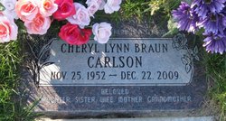
Cheryl Lynn Braun Carlson
| Birth | : | 25 Nov 1952 Havre, Hill County, Montana, USA |
| Death | : | 22 Dec 2009 Spokane, Spokane County, Washington, USA |
| Burial | : | St. Luke's Churchyard, Endon, Staffordshire Moorlands District, England |
| Coordinate | : | 53.0812200, -2.1086100 |
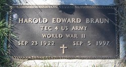
| Description | : | Obit from Find A Grave contributor "Cara": Havre Daily News (MT), 28 Dec 2009 Cheryl Lynn Braun Carlson, 57, left this world Dec. 22, in Spokane, Wash., following complications from heart surgery. Her memorial service will be 11 a.m. Wednesday, at the First Lutheran Church, with Pastor Brad Ulgenes officiating. A fellowship luncheon will follow at the church immediately after the service. A private family burial will be held at a later time. Cheryl was born in Havre, Mont., on Nov. 25, 1952, to Harold E. and Edith (Moore) Braun. She was raised west of Big... Read More |
frequently asked questions (FAQ):
-
Where is Cheryl Lynn Braun Carlson's memorial?
Cheryl Lynn Braun Carlson's memorial is located at: St. Luke's Churchyard, Endon, Staffordshire Moorlands District, England.
-
When did Cheryl Lynn Braun Carlson death?
Cheryl Lynn Braun Carlson death on 22 Dec 2009 in Spokane, Spokane County, Washington, USA
-
Where are the coordinates of the Cheryl Lynn Braun Carlson's memorial?
Latitude: 53.0812200
Longitude: -2.1086100
Family Members:
Parent
Flowers:


Nearby Cemetories:
1. St. Luke's Churchyard
Endon, Staffordshire Moorlands District, England
Coordinate: 53.0812200, -2.1086100
2. St Anne Churchyard
Brown Edge, Staffordshire Moorlands District, England
Coordinate: 53.0832490, -2.1429880
3. St Chad Churchyard
Bagnall, Staffordshire Moorlands District, England
Coordinate: 53.0558430, -2.1082770
4. St Chad Churchyard
Longsdon, Staffordshire Moorlands District, England
Coordinate: 53.0887220, -2.0625850
5. St. Michael and All Angels Churchyard
Horton, Staffordshire Moorlands District, England
Coordinate: 53.1135330, -2.0879040
6. St. Michael's Churchyard Extension
Horton, Staffordshire Moorlands District, England
Coordinate: 53.1139430, -2.0878020
7. St. Philip and St. James Churchyard
Milton, Stoke-on-Trent Unitary Authority, England
Coordinate: 53.0503730, -2.1403780
8. St Bartholomew Churchyard
Norton in the Moors, Stoke-on-Trent Unitary Authority, England
Coordinate: 53.0604630, -2.1595270
9. St Edward the Confessor Churchyard
Cheddleton, Staffordshire Moorlands District, England
Coordinate: 53.0689530, -2.0448230
10. Carmountside Cemetery and Crematorium
Milton, Stoke-on-Trent Unitary Authority, England
Coordinate: 53.0449570, -2.1394910
11. St Edwards Lawn Cemetery
Cheddleton, Staffordshire Moorlands District, England
Coordinate: 53.0744437, -2.0385063
12. Christ Church Churchyard
Biddulph Moor, Staffordshire Moorlands District, England
Coordinate: 53.1220780, -2.1402320
13. Parish church of st saviour smallthorne
Smallthorne, Stoke-on-Trent Unitary Authority, England
Coordinate: 53.0497445, -2.1758707
14. St John the Baptist Churchyard
Wetley Rocks, Staffordshire Moorlands District, England
Coordinate: 53.0409100, -2.0555020
15. Smallthorne Cemetery
Smallthorne, Stoke-on-Trent Unitary Authority, England
Coordinate: 53.0480310, -2.1765950
16. Burslem Cemetery
Burslem, Stoke-on-Trent Unitary Authority, England
Coordinate: 53.0463020, -2.1747030
17. Leek Cemetery
Leek, Staffordshire Moorlands District, England
Coordinate: 53.1000880, -2.0248680
18. St Edward the Confessor Churchyard
Leek, Staffordshire Moorlands District, England
Coordinate: 53.1068190, -2.0266150
19. St. Lawrence Churchyard
Biddulph, Staffordshire Moorlands District, England
Coordinate: 53.1281320, -2.1659070
20. St Luke Churchyard
Leek, Staffordshire Moorlands District, England
Coordinate: 53.1061400, -2.0191430
21. St. James the Apostle Churchyard
Newchapel, Newcastle-Under-Lyme Borough, England
Coordinate: 53.0874630, -2.2069790
22. St. Mary's Churchyard
Bucknall, Stoke-on-Trent Unitary Authority, England
Coordinate: 53.0240220, -2.1424430
23. Holy Trinity Churchyard
Hanley, Stoke-on-Trent Unitary Authority, England
Coordinate: 53.0297350, -2.1672050
24. Abbey of St Mary
Abbey Hulton, Stoke-on-Trent Unitary Authority, England
Coordinate: 53.0200000, -2.1300000