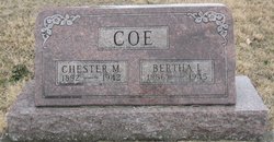
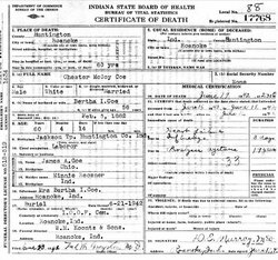
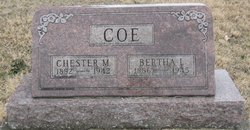
Chester McCoy Coe
| Birth | : | 5 Feb 1882 Roanoke, Huntington County, Indiana, USA |
| Death | : | 19 Jun 1942 Roanoke, Huntington County, Indiana, USA |
| Burial | : | Beulah Baptist Church Cemetery, Henderson County, USA |
| Coordinate | : | 35.3041992, -82.5580978 |
| Description | : | also known as Chester Stephen McCoy Coe |
frequently asked questions (FAQ):
-
Where is Chester McCoy Coe's memorial?
Chester McCoy Coe's memorial is located at: Beulah Baptist Church Cemetery, Henderson County, USA.
-
When did Chester McCoy Coe death?
Chester McCoy Coe death on 19 Jun 1942 in Roanoke, Huntington County, Indiana, USA
-
Where are the coordinates of the Chester McCoy Coe's memorial?
Latitude: 35.3041992
Longitude: -82.5580978
Family Members:
Parent
Spouse
Siblings
Children
Flowers:
Nearby Cemetories:
1. Beulah Baptist Church Cemetery
Henderson County, USA
Coordinate: 35.3041992, -82.5580978
2. Oak Forest Cemetery
Etowah, Henderson County, USA
Coordinate: 35.3081017, -82.5858002
3. Sentell Family Cemetery
Henderson County, USA
Coordinate: 35.2752991, -82.5468979
4. Thomas Fletcher Cemetery
Etowah, Henderson County, USA
Coordinate: 35.2969017, -82.5947037
5. Brown Family Cemetery
Henderson County, USA
Coordinate: 35.2779600, -82.5336300
6. Pleasant Grove Cemetery
Etowah, Henderson County, USA
Coordinate: 35.2888985, -82.5999985
7. Old Beulah Cemetery
Henderson County, USA
Coordinate: 35.2961006, -82.6082993
8. Follies Cemeteries
Etowah, Henderson County, USA
Coordinate: 35.2660600, -82.5817900
9. Cantrell Family Cemetery
Henderson County, USA
Coordinate: 35.2869119, -82.5096819
10. Shaws Creek Methodist Campground Cemetery
Horse Shoe, Henderson County, USA
Coordinate: 35.3437996, -82.5345001
11. Jeremiah Osborne Cemetery
Horse Shoe, Henderson County, USA
Coordinate: 35.3527400, -82.5551720
12. Crab Creek Church Cemetery
Henderson County, USA
Coordinate: 35.2536490, -82.5572710
13. Saint Francis Chapel Memorial Garden
Henderson County, USA
Coordinate: 35.2641670, -82.5200440
14. Shaws Creek Baptist Church Cemetery
Horse Shoe, Henderson County, USA
Coordinate: 35.3231010, -82.4983978
15. Pleasant Hill Cemetery
Valley Hill, Henderson County, USA
Coordinate: 35.2750015, -82.4993973
16. Old French Broad Baptist Church
Rugby, Henderson County, USA
Coordinate: 35.3588340, -82.5418500
17. Crab Creek Baptist Church Cemetery
Henderson County, USA
Coordinate: 35.2454987, -82.5476990
18. Sentell Cemetery
Henderson County, USA
Coordinate: 35.2593994, -82.6061020
19. Adriance Family Cemetery
Henderson County, USA
Coordinate: 35.2511700, -82.5238300
20. McCarson Cemetery
Henderson County, USA
Coordinate: 35.3442001, -82.5021973
21. First Congregational Church Memorial Garden
Hendersonville, Henderson County, USA
Coordinate: 35.3151530, -82.4841940
22. Harden Family Cemetery
Henderson County, USA
Coordinate: 35.2505100, -82.5191000
23. Anderson Cemetery
Henderson County, USA
Coordinate: 35.2502000, -82.6002300
24. Grace Lutheran Church Memorial Garden
Hendersonville, Henderson County, USA
Coordinate: 35.3212100, -82.4786900

