


Clara M St Clair Milner
| Birth | : | 6 Mar 1877 Iowa, USA |
| Death | : | 1 Jan 1962 |
| Burial | : | All Saints Churchyard, Dickleburgh and Rushall, South Norfolk District, England |
| Coordinate | : | 52.3968580, 1.1848010 |
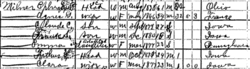
| Description | : | "Iowa, County Marriages, 1838-1934" Name: Arthur Milner Event Type: Marriage Event Date: 30 Apr 1899 Event Place: Red Oak, Montgomery, Iowa, United States Age: 24 Father's Name: Ephram P. Milner Mother's Name: Agnes Dujardin Spouse's Name: Clara St Clair Spouse's Birth Year (Estimated): 1876 Spouse's Father's Name: B. A. St Clair Spouse's Mother's Name: Mary Weatherly Reference ID: p126 1996 GS Film number: 1481225 Digital Folder Number: 004320552 Citing this Record "Iowa, County Marriages, 1838-1934," index, FamilySearch (https://familysearch.org/pal:/MM9.1.1/XJDB-N3F : accessed 09 Dec 2013), Arthur Milner and Clara St Clair, 1899. |
frequently asked questions (FAQ):
-
Where is Clara M St Clair Milner's memorial?
Clara M St Clair Milner's memorial is located at: All Saints Churchyard, Dickleburgh and Rushall, South Norfolk District, England.
-
When did Clara M St Clair Milner death?
Clara M St Clair Milner death on 1 Jan 1962 in
-
Where are the coordinates of the Clara M St Clair Milner's memorial?
Latitude: 52.3968580
Longitude: 1.1848010
Family Members:
Flowers:


Nearby Cemetories:
1. All Saints Churchyard
Dickleburgh and Rushall, South Norfolk District, England
Coordinate: 52.3968580, 1.1848010
2. St. George's Churchyard
Shimpling, Babergh District, England
Coordinate: 52.3994010, 1.1680910
3. Saint George Churchyard
Shimpling, South Norfolk District, England
Coordinate: 52.3993000, 1.1680000
4. St Mary Churchyard
Dickleburgh and Rushall, South Norfolk District, England
Coordinate: 52.3978750, 1.2290680
5. Saint Mary the Virgin Churchyard
Burston, South Norfolk District, England
Coordinate: 52.4049300, 1.1402600
6. St Leonard Churchyard
Billingford, South Norfolk District, England
Coordinate: 52.3666290, 1.1834260
7. Saint Mary Churchyard
Gissing, South Norfolk District, England
Coordinate: 52.4235630, 1.1548260
8. Saint Andrew Churchyard
Scole, South Norfolk District, England
Coordinate: 52.3671670, 1.1579150
9. St Andrew's Frenze Church
Scole, South Norfolk District, England
Coordinate: 52.3802000, 1.1361000
10. St. Peter and St. Paul Churchyard
Brockdish, South Norfolk District, England
Coordinate: 52.3705240, 1.2366100
11. Pulham Market Cemetery
Pulham Market, South Norfolk District, England
Coordinate: 52.4281900, 1.2297700
12. Saint Mary Magdalene Churchyard
Pulham Market, South Norfolk District, England
Coordinate: 52.4285200, 1.2301100
13. St. Margaret's Churchyard
Syleham, Mid Suffolk District, England
Coordinate: 52.3641870, 1.2372060
14. Saint Peter and St. Paul Churchyard
Hoxne, Mid Suffolk District, England
Coordinate: 52.3522270, 1.2016300
15. St. Nicholas Churchyard
Oakley, Mid Suffolk District, England
Coordinate: 52.3518380, 1.1662190
16. Diss Cemetery
Diss, South Norfolk District, England
Coordinate: 52.3839060, 1.1115880
17. St Mary the Virgin Churchyard
Pulham St Mary, South Norfolk District, England
Coordinate: 52.4205290, 1.2520380
18. Saint Mary Churchyard
Diss, South Norfolk District, England
Coordinate: 52.3772370, 1.1097880
19. Diss War Memorial
Diss, South Norfolk District, England
Coordinate: 52.3773380, 1.1088530
20. All Saints Churchyard
Stuston, Mid Suffolk District, England
Coordinate: 52.3571980, 1.1332590
21. Croft Lane Baptist Church Burial Ground
Diss, South Norfolk District, England
Coordinate: 52.3771070, 1.1025490
22. Unitarian Chapel Cemetery
Palgrave, Mid Suffolk District, England
Coordinate: 52.3693130, 1.1086820
23. All Saints Churchyard
Shelfanger, South Norfolk District, England
Coordinate: 52.4104780, 1.0969230
24. St Peter Churchyard
Needham, South Norfolk District, England
Coordinate: 52.3896320, 1.2773700