
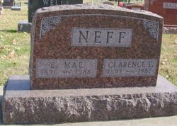
Clarence Edward Neff
| Birth | : | 20 May 1893 Clarke County, Iowa, USA |
| Death | : | 17 Nov 1987 Osceola, Clarke County, Iowa, USA |
| Burial | : | Bacup Cemetery, Bacup, Rossendale Borough, England |
| Coordinate | : | 53.6906780, -2.2156640 |
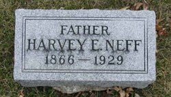
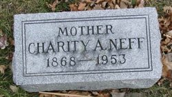
| Description | : | Osceola Sentinel Tribune November 19, 1987 Services for Clarence Edward Neff, 94, of Osceola, who died Tuesday, November 17, 1987 at Clarke County Hospital, will be held Friday, November 20 at 2 p.m. at Kale Funeral Home. The Rev. Neville Clayton of Osceola will officiate at the servies with burial in Maple Hill Cemetery, Osceola. Mr. Neff was born May 20, 1893 in Clarke County, the son of Harvey Edward Neff and Charity Ann Adams Neff. He married Ethel Mae DeLong on August 15, 1817 in Osceola. He was a farmer. He was a member of the... Read More |
frequently asked questions (FAQ):
-
Where is Clarence Edward Neff's memorial?
Clarence Edward Neff's memorial is located at: Bacup Cemetery, Bacup, Rossendale Borough, England.
-
When did Clarence Edward Neff death?
Clarence Edward Neff death on 17 Nov 1987 in Osceola, Clarke County, Iowa, USA
-
Where are the coordinates of the Clarence Edward Neff's memorial?
Latitude: 53.6906780
Longitude: -2.2156640
Family Members:
Parent
Spouse

Siblings
Children
Flowers:


Nearby Cemetories:
1. Mount Pleasant Wesleyan Chapelyard
Bacup, Rossendale Borough, England
Coordinate: 53.6924900, -2.2228100
2. St John the Evangelist Churchyard
Bacup, Rossendale Borough, England
Coordinate: 53.7037300, -2.2019600
3. Ebenezer Particular Baptist Chapel Chapelyard
Bacup, Rossendale Borough, England
Coordinate: 53.7045700, -2.1997500
4. Newchurch Methodist Churchyard
Newchurch, Rossendale Borough, England
Coordinate: 53.6983460, -2.2501260
5. St. Nicholas Churchyard
Newchurch, Rossendale Borough, England
Coordinate: 53.6972220, -2.2524660
6. Bethlehem Chapel Graveyard
Newchurch, Rossendale Borough, England
Coordinate: 53.6976970, -2.2522620
7. Saint Anne's Churchyard Edgeside
Waterfoot, Rossendale Borough, England
Coordinate: 53.7031600, -2.2482700
8. Saint Michael on the Hill Churchyard
Lumb, Rossendale Borough, England
Coordinate: 53.7201000, -2.2479300
9. Lumb Baptist Church Cemetery
Waterfoot, Rossendale Borough, England
Coordinate: 53.7229340, -2.2455170
10. Whitworth Cemetery
Whitworth, Rossendale Borough, England
Coordinate: 53.6671650, -2.1674750
11. Friends Burial Ground
Rossendale, Rossendale Borough, England
Coordinate: 53.7091000, -2.2757160
12. Unitarian Chapel Burial Ground
Rossendale, Rossendale Borough, England
Coordinate: 53.7024380, -2.2856290
13. Longholme Methodist Cemetery
Rawtenstall, Rossendale Borough, England
Coordinate: 53.7009730, -2.2865000
14. Rawtenstall Cemetery
Rawtenstall, Rossendale Borough, England
Coordinate: 53.7060200, -2.2847500
15. St Bartholomew Churchyard
Whitworth, Rossendale Borough, England
Coordinate: 53.6553000, -2.1709700
16. Cloughfoot Independent Congregational Chapelyard
Todmorden, Metropolitan Borough of Calderdale, England
Coordinate: 53.7113850, -2.1379180
17. Broadleys Garden
Rawtenstall, Rossendale Borough, England
Coordinate: 53.7176321, -2.2904764
18. Burnley Road Cemetery, Reedsholme, Rossendale
Rossendale Borough, England
Coordinate: 53.7178398, -2.2904316
19. Crawshawbooth Quaker Burial Ground
Crawshawbooth, Rossendale Borough, England
Coordinate: 53.7242420, -2.2879400
20. Edenfield Parish Churchyard
Ramsbottom, Metropolitan Borough of Bury, England
Coordinate: 53.6742799, -2.3069304
21. St. Mary and All Saints Churchyard
Goodshaw, Rossendale Borough, England
Coordinate: 53.7315270, -2.2828940
22. Goodshaw Particular Baptist Chapel Graveyard
Goodshaw, Rossendale Borough, England
Coordinate: 53.7328210, -2.2815530
23. Christ Church Churchyard
Healey, Metropolitan Borough of Rochdale, England
Coordinate: 53.6378630, -2.1741198
24. Mount Zion Methodist Chapleyard
Cornholme, Metropolitan Borough of Calderdale, England
Coordinate: 53.7331400, -2.1457800