
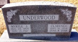
Clarence L “Pete” Underwood
| Birth | : | 17 Sep 1906 Concordia, Cloud County, Kansas, USA |
| Death | : | 8 Jun 2006 Kansas, USA |
| Burial | : | Mount Hope Cemetery, Clyde, Cloud County, USA |
| Coordinate | : | 39.5969009, -97.4116974 |
| Plot | : | 13-13 |
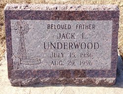
| Description | : | parents of Jack, Jerry & Lois Salina Journal – Jun. 9, 2006 Clarence L. "Pete" Underwood CLIFTON — Clarence L. "Pete" Underwood, 96, Clifton, died Thursday June 8, 2006. Mr. Underwood was born Sept. 17, 1909, in Concordia. He was a retired farmer. He was preceded in death by three wives; a son, Jack; and a grandson. Survivors include a son, Jerry of Bellville; a daughter, Louis Kauer of Salina; five grandchildren; six step-grandchildren; 12 great-grandchildren; and numerous step-great-grandchildren. The funeral will be at 10 a.m. Saturday at St. John the Baptist Catholic Church, Clyde. Burial will be in Mount Hope Cemetery Clyde, with Masonic services... Read More |
frequently asked questions (FAQ):
-
Where is Clarence L “Pete” Underwood's memorial?
Clarence L “Pete” Underwood's memorial is located at: Mount Hope Cemetery, Clyde, Cloud County, USA.
-
When did Clarence L “Pete” Underwood death?
Clarence L “Pete” Underwood death on 8 Jun 2006 in Kansas, USA
-
Where are the coordinates of the Clarence L “Pete” Underwood's memorial?
Latitude: 39.5969009
Longitude: -97.4116974
Family Members:
Spouse

Children
Flowers:


Nearby Cemetories:
1. Mount Calvary Cemetery
Clyde, Cloud County, USA
Coordinate: 39.5917015, -97.4143982
2. Cedar Grove Cemetery
Clyde, Cloud County, USA
Coordinate: 39.5494003, -97.4056015
3. Pleasant View Cemetery
Ames, Cloud County, USA
Coordinate: 39.5346985, -97.4431000
4. Walnut Grove Cemetery
Cloud County, USA
Coordinate: 39.5699997, -97.4993973
5. Agenda Cemetery
Agenda, Republic County, USA
Coordinate: 39.6761017, -97.4336014
6. Saint Joseph Cemetery
Saint Joseph, Cloud County, USA
Coordinate: 39.5074941, -97.4022328
7. Beck Family Cemetery
Agenda, Republic County, USA
Coordinate: 39.6818000, -97.4863000
8. Green Mound Cemetery
Rice, Cloud County, USA
Coordinate: 39.5248450, -97.5081630
9. Hollis Cemetery
Cloud County, USA
Coordinate: 39.6383018, -97.5361023
10. Rice Cemetery
Rice, Cloud County, USA
Coordinate: 39.5614014, -97.5552979
11. Nelson Cemetery
Rice, Cloud County, USA
Coordinate: 39.5257988, -97.5410995
12. Riverdale Cemetery
Clay County, USA
Coordinate: 39.5106010, -97.2930984
13. Willoughby Cemetery
Agenda, Republic County, USA
Coordinate: 39.7402992, -97.4244003
14. Union Cemetery
Wayne, Republic County, USA
Coordinate: 39.6977997, -97.5457993
15. Saint Peters Cemetery
Aurora, Cloud County, USA
Coordinate: 39.4763985, -97.5180969
16. Princeville Cemetery
Aurora, Cloud County, USA
Coordinate: 39.4672012, -97.5010986
17. Iwacura Cemetery
Morganville, Clay County, USA
Coordinate: 39.4550000, -97.3510000
18. Gotland Cemetery
Sibley Township, Cloud County, USA
Coordinate: 39.6091995, -97.6125031
19. French Presbyterian Church Cemetery
Cloud County, USA
Coordinate: 39.4395200, -97.4148290
20. Sherman Cemetery
Morganville, Clay County, USA
Coordinate: 39.5316300, -97.2243700
21. Zion Cemetery
Agenda, Republic County, USA
Coordinate: 39.6749992, -97.5939026
22. Rose Hill Cemetery
Wayne, Republic County, USA
Coordinate: 39.7111015, -97.5661011
23. Minersville Cemetery
Talmo, Republic County, USA
Coordinate: 39.6568330, -97.6229250
24. Bloom Cemetery
Morganville, Clay County, USA
Coordinate: 39.4519005, -97.2778015