
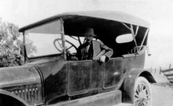
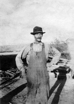

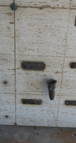
Claude Hamilton Griswold
| Birth | : | 15 May 1872 Rome Center, Lenawee County, Michigan, USA |
| Death | : | 25 May 1919 Red Bluff, Tehama County, California, USA |
| Burial | : | Oak Hill Cemetery, Red Bluff, Tehama County, USA |
| Coordinate | : | 40.1699982, -122.2433014 |
| Plot | : | Block 26-4-18 |
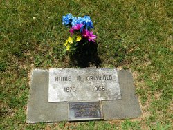
| Description | : | Claude Griswold was born in Rome, Michigan where his parents lived until he was about 10 then in South Dakota near his Uncle Eber's homestead. By the early 1890's they were living on their own homestead in Haxtun CO where his mother Emma died. His father, brother and sister soon left the area. Claude moved to Ouray CO where he worked as a 'steam engineer' at a lumber mill, married Annie McKinley and soon joined the extended McKinley family as miners. They remained together, moving first to Delamar NV, to Tacoma WA and finally to nearby... Read More |
frequently asked questions (FAQ):
-
Where is Claude Hamilton Griswold's memorial?
Claude Hamilton Griswold's memorial is located at: Oak Hill Cemetery, Red Bluff, Tehama County, USA.
-
When did Claude Hamilton Griswold death?
Claude Hamilton Griswold death on 25 May 1919 in Red Bluff, Tehama County, California, USA
-
Where are the coordinates of the Claude Hamilton Griswold's memorial?
Latitude: 40.1699982
Longitude: -122.2433014
Family Members:
Parent
Spouse
Siblings
Children
Flowers:


Nearby Cemetories:
1. Red Bluff Memorial Chapel Mausoleum & Columbarium
Red Bluff, Tehama County, USA
Coordinate: 40.1717130, -122.2466860
2. Saint Mary's Cemetery
Red Bluff, Tehama County, USA
Coordinate: 40.1716995, -122.2521973
3. Growney Ranch Family Cemetery
Red Bluff, Tehama County, USA
Coordinate: 40.1167300, -122.1952500
4. Los Molinos Cemetery
Los Molinos, Tehama County, USA
Coordinate: 40.0475650, -122.1011820
5. Tehama Cemetery
Tehama, Tehama County, USA
Coordinate: 40.0233002, -122.1433029
6. Red Bank Cemetery
Red Bank, Tehama County, USA
Coordinate: 40.1036970, -122.4458540
7. Inks Creek Cemetery
Tehama County, USA
Coordinate: 40.3419800, -122.1297100
8. Cottonwood Creek Ranch Cemetery
Cottonwood, Shasta County, USA
Coordinate: 40.3663100, -122.2598800
9. Cottonwood Cemetery
Cottonwood, Shasta County, USA
Coordinate: 40.3856100, -122.2936500
10. Major Pierson B Reading Family Cemetery
Cottonwood, Shasta County, USA
Coordinate: 40.3924300, -122.2126900
11. Sunset Hill Cemetery
Corning, Tehama County, USA
Coordinate: 39.9271600, -122.1586100
12. Sleepy Hollow Pet Cemetery
Anderson, Shasta County, USA
Coordinate: 40.4199430, -122.2858410
13. Rosewood Cemetery
Rosewood, Tehama County, USA
Coordinate: 40.2685360, -122.5575190
14. New Clairvaux Abbey Cemetery
Vina, Tehama County, USA
Coordinate: 39.9381450, -122.0641890
15. Anderson District Cemetery
Anderson, Shasta County, USA
Coordinate: 40.4419518, -122.2967300
16. Oddfellows Cemetery
Anderson, Shasta County, USA
Coordinate: 40.4431590, -122.2907070
17. Anderson Pioneer Cemetery
Anderson, Shasta County, USA
Coordinate: 40.4439011, -122.2904968
18. Vina Cemetery
Vina, Tehama County, USA
Coordinate: 39.9636440, -121.9957070
19. Lowrey Cemetery
Tehama County, USA
Coordinate: 40.0066986, -122.5635986
20. Cameron-Davis Cemetery
Tehama County, USA
Coordinate: 40.2709800, -121.8778500
21. Parkville Cemetery
Anderson, Shasta County, USA
Coordinate: 40.4640200, -122.1897500
22. Lanes Valley Cemetery
Paynes Creek, Tehama County, USA
Coordinate: 40.3998400, -121.9762400
23. Pinckney Cemetery
Cottonwood, Shasta County, USA
Coordinate: 40.3997002, -122.5180969
24. Kirkwood Cemetery
Corning, Tehama County, USA
Coordinate: 39.8624992, -122.1519012