
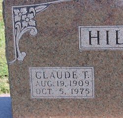

Claude Thurder Hill
| Birth | : | 19 Aug 1909 Moniteau County, Missouri, USA |
| Death | : | 5 Oct 1975 Moniteau County, Missouri, USA |
| Burial | : | Second Creek Cemetery, Blanchester, Clinton County, USA |
| Coordinate | : | 39.3164800, -83.9551600 |
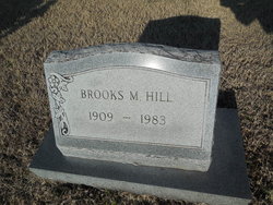
| Description | : | 1940 --- U. S. WORLD WAR II DRAFT CARDS YOUNG MEN 1940-1947 Name: Claude Thurber Hill Gender: Male Race: White Age: 31 Relationship to Draftee: Self (Head) Birth Date: August 19, 1909 Birth Place: Moniteau, Missouri, USA Residence Place: California, Moniteau, Missouri , USA Registration Date: October 16, 1940 Registration Place: California, Moniteau, Missouri , USA Employer: Self Farming Weight: 170 Complexion: Light Eye Color: Brown Hair Color: Brown Height: 5' 10" Next of Kin: Brooks Hill Household Members: Claude Thurber Hill - Self (Head) --- Brooks Hill - Wife Researcher: Richard Parker Source Citation: The National Archives... Read More |
frequently asked questions (FAQ):
-
Where is Claude Thurder Hill's memorial?
Claude Thurder Hill's memorial is located at: Second Creek Cemetery, Blanchester, Clinton County, USA.
-
When did Claude Thurder Hill death?
Claude Thurder Hill death on 5 Oct 1975 in Moniteau County, Missouri, USA
-
Where are the coordinates of the Claude Thurder Hill's memorial?
Latitude: 39.3164800
Longitude: -83.9551600
Family Members:
Parent
Spouse
Flowers:


Nearby Cemetories:
1. Second Creek Cemetery
Blanchester, Clinton County, USA
Coordinate: 39.3164800, -83.9551600
2. Osborne Cemetery
Harlan Township, Warren County, USA
Coordinate: 39.3224983, -84.0038986
3. Blanchester IOOF Cemetery
Blanchester, Clinton County, USA
Coordinate: 39.2921982, -83.9957962
4. Rehobath Cemetery
Blanchester, Clinton County, USA
Coordinate: 39.3512000, -83.9292000
5. Jefferson Township Unidentified Cemetery #1
Jefferson Township, Clinton County, USA
Coordinate: 39.3143720, -83.9028310
6. Garrison Cemetery
Blanchester, Clinton County, USA
Coordinate: 39.2703018, -83.9681015
7. West Mary Cemetery
Harlan Township, Warren County, USA
Coordinate: 39.3008003, -84.0152969
8. Westboro IOOF Cemetery
Westboro, Clinton County, USA
Coordinate: 39.2845700, -83.9042900
9. Westboro Friends Cemetery
Westboro, Clinton County, USA
Coordinate: 39.2849998, -83.9013977
10. New Hope Cemetery
Harlan Township, Warren County, USA
Coordinate: 39.3088989, -84.0239029
11. Pleasant Grove Cemetery
Warren County, USA
Coordinate: 39.3400610, -84.0185430
12. Sewell Cemetery
Clarksville, Clinton County, USA
Coordinate: 39.3782997, -83.9552994
13. Edwardsville Cemetery
Edwardsville, Warren County, USA
Coordinate: 39.3333780, -84.0342390
14. Moore-Johns Cemetery
Cuba, Clinton County, USA
Coordinate: 39.3474600, -83.8772500
15. Rossella Cemetery
Pleasant Plain, Warren County, USA
Coordinate: 39.3244019, -84.0421982
16. Vernon Baptist Cemetery
Vernon Township, Clinton County, USA
Coordinate: 39.3873890, -83.9667060
17. Wesley Chapel Cemetery
Pleasant Plain, Warren County, USA
Coordinate: 39.2778015, -84.0355988
18. West Woodville Cemetery
Warren County, USA
Coordinate: 39.2561660, -84.0114110
19. Mount Pleasant Cemetery
Vernon Township, Clinton County, USA
Coordinate: 39.3806000, -83.8972015
20. Templin Cemetery
Pleasant Plain, Warren County, USA
Coordinate: 39.3107986, -84.0622025
21. Clarksville Cemetery
Clarksville, Clinton County, USA
Coordinate: 39.3972900, -83.9841100
22. Clarksville Friends Cemetery
Clarksville, Clinton County, USA
Coordinate: 39.4022835, -83.9749430
23. Union Church Cemetery
Middleboro, Warren County, USA
Coordinate: 39.3897100, -84.0219500
24. Mann Farm Cemetery
Washington Township, Clinton County, USA
Coordinate: 39.3478970, -83.8463420