
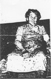
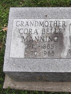

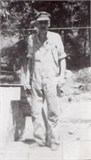
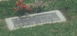
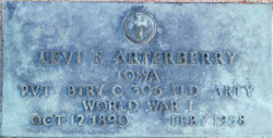
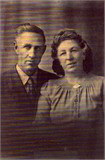
Cora Belle Arterberry Manning
| Birth | : | 13 Mar 1885 Tulsa, Tulsa County, Oklahoma, USA |
| Death | : | 20 Aug 1968 Maquoketa, Jackson County, Iowa, USA |
| Burial | : | Darwen Eastern Cemetery, Darwen, Blackburn with Darwen Unitary Authority, England |
| Coordinate | : | 53.6769300, -2.4547700 |
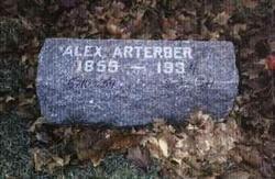
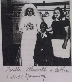
| Description | : | Cora Belle Arterberry Manning Clinton Herald Newspaper - Clinton, Clinton County, Iowa - provided by Bev Skoff from Cora's daughter, Blanche Marie Manning Massey Mrs Cora Manning, 83, longtime Jackson County resident died Tuesday, August 20, 1968, in a Maquoketa Nursing Home. The funeral will be 2 pm Friday in the Carson Funeral Home here by Rev Jerry Wolcott of the Maquoketa Methodist Church. Burial will be in Mt Hope Cemetery. Friends may call after 2 pm Thursday in the funeral home. Cora Belle Arterberry was born March 13, 1885, to Alexander & Josephine Walker Arterberry of Tulsa, Oklahoma. She married Harvey Lee... Read More |
frequently asked questions (FAQ):
-
Where is Cora Belle Arterberry Manning's memorial?
Cora Belle Arterberry Manning's memorial is located at: Darwen Eastern Cemetery, Darwen, Blackburn with Darwen Unitary Authority, England.
-
When did Cora Belle Arterberry Manning death?
Cora Belle Arterberry Manning death on 20 Aug 1968 in Maquoketa, Jackson County, Iowa, USA
-
Where are the coordinates of the Cora Belle Arterberry Manning's memorial?
Latitude: 53.6769300
Longitude: -2.4547700
Family Members:
Parent
Spouse
Siblings

Children
Flowers:


Nearby Cemetories:
1. Darwen Eastern Cemetery
Darwen, Blackburn with Darwen Unitary Authority, England
Coordinate: 53.6769300, -2.4547700
2. Darwen Cemetery
Darwen, Blackburn with Darwen Unitary Authority, England
Coordinate: 53.6781400, -2.4598300
3. St Peters Churchyard
Darwen, Blackburn with Darwen Unitary Authority, England
Coordinate: 53.6955520, -2.4648090
4. St. Paul's Churchyard
Darwen, Blackburn with Darwen Unitary Authority, England
Coordinate: 53.6979270, -2.4318640
5. Pickup Bank Congregational Chapel
Pickup Bank, Blackburn with Darwen Unitary Authority, England
Coordinate: 53.7012440, -2.4164220
6. Belmont Congregational Churchyard
Belmont, Blackburn with Darwen Unitary Authority, England
Coordinate: 53.6419917, -2.4955512
7. Edgworth Congregational Chapelyard
Edgworth, Blackburn with Darwen Unitary Authority, England
Coordinate: 53.6476280, -2.3967210
8. St Peter Churchyard
Belmont, Blackburn with Darwen Unitary Authority, England
Coordinate: 53.6379520, -2.4955480
9. St Stephen Churchyard
Tockholes, Blackburn with Darwen Unitary Authority, England
Coordinate: 53.7058350, -2.5169320
10. St James Churchyard
Lower Darwen, Blackburn with Darwen Unitary Authority, England
Coordinate: 53.7245510, -2.4634700
11. Methodist Church Churchyard
Edgworth, Blackburn with Darwen Unitary Authority, England
Coordinate: 53.6424280, -2.3962830
12. St. Anne's Churchyard
Chapeltown, Blackburn with Darwen Unitary Authority, England
Coordinate: 53.6371710, -2.4030440
13. New Row Methodist Church
Blackburn with Darwen Unitary Authority, England
Coordinate: 53.7208950, -2.5023720
14. Christ Church Churchyard
Egerton, Metropolitan Borough of Bolton, England
Coordinate: 53.6237080, -2.4389210
15. Haslingden Grane Methodist Chapel Cemetery
Haslingden, Rossendale Borough, England
Coordinate: 53.7016300, -2.3728190
16. St Paul's Churchyard
Withnell, Chorley Borough, England
Coordinate: 53.6970740, -2.5592150
17. Immanuel Churchyard
Oswaldwistle, Hyndburn Borough, England
Coordinate: 53.7358300, -2.4056200
18. New Lane Baptist Chapel Chapelyard
Oswaldwistle, Hyndburn Borough, England
Coordinate: 53.7381100, -2.4049500
19. Hawkshaw Methodist Church Cemetery
Hawkshaw, Metropolitan Borough of Bury, England
Coordinate: 53.6313490, -2.3674190
20. Haslingden Cemetery
Haslingden, Rossendale Borough, England
Coordinate: 53.6989500, -2.3427700
21. Holden Hall Cemetery
Haslingden, Rossendale Borough, England
Coordinate: 53.6989870, -2.3427780
22. St. Peter's Churchyard
Blackburn, Blackburn with Darwen Unitary Authority, England
Coordinate: 53.7448110, -2.4865070
23. Independent Chapel Churchyard
Blackburn, Blackburn with Darwen Unitary Authority, England
Coordinate: 53.7454960, -2.4864460
24. St Mary Churchyard
Hawkshaw, Metropolitan Borough of Bury, England
Coordinate: 53.6307270, -2.3636210