
| Birth | : | 10 Apr 1930 Keosauqua, Van Buren County, Iowa, USA |
| Death | : | 19 Apr 2015 Iowa City, Johnson County, Iowa, USA |
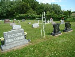
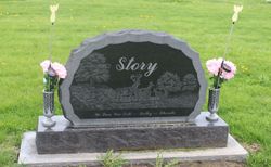
| Burial | : | Friends Cemetery, Pleasant Plain, Jefferson County, USA |
| Coordinate | : | 41.1478004, -91.8636017 |
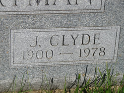
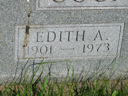
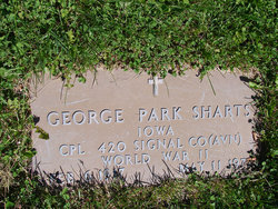
| Description | : | Cornelia "Louise" Hoskins, age 85, of Fairfield, passed away Sunday, April 19, 2015 at University of Iowa Hospital & Clinics, Iowa City, IA. Louise was born April 10, 1930 to Clyde and Edith(Bonar)Countryman in Keosauqua, IA. She married George Sharts in 1948. He passed away 1971. In 1972 she married Hubert Hoskins at the Pleasant Plain Friends Church. Louise lived most of her life in Jefferson County and was a homemaker. She was a member of Pleasant Plain Friends Church. Cornella loved spending time with family and friends, especially her children and grandchildren. Louise is survived by her... Read More |
frequently asked questions (FAQ):
-
Where is Cornelia “Louise” Countryman Hoskins's memorial?
Cornelia “Louise” Countryman Hoskins's memorial is located at: Friends Cemetery, Pleasant Plain, Jefferson County, USA.
-
When did Cornelia “Louise” Countryman Hoskins death?
Cornelia “Louise” Countryman Hoskins death on 19 Apr 2015 in Iowa City, Johnson County, Iowa, USA
-
Where are the coordinates of the Cornelia “Louise” Countryman Hoskins's memorial?
Latitude: 41.1478004
Longitude: -91.8636017
Family Members:
Parent
Spouse

Siblings
Flowers:


Nearby Cemetories:
1. Friends Cemetery
Pleasant Plain, Jefferson County, USA
Coordinate: 41.1478004, -91.8636017
2. Saint Josephs Cemetery
Pleasant Plain, Jefferson County, USA
Coordinate: 41.1357994, -91.8463974
3. Walnut Creek Friends Cemetery
Pleasant Plain, Jefferson County, USA
Coordinate: 41.1237500, -91.8747500
4. Hillcrest Cemetery
Brighton, Washington County, USA
Coordinate: 41.1796989, -91.8174973
5. Polishville Cemetery
East Pleasant Plain, Jefferson County, USA
Coordinate: 41.1116982, -91.8131027
6. Westenhaver Family Cemetery
Perlee, Jefferson County, USA
Coordinate: 41.0968240, -91.8829110
7. Laux Park Family Cemetery
Brighton, Washington County, USA
Coordinate: 41.1913920, -91.9098620
8. Clay Cemetery
Rubio, Washington County, USA
Coordinate: 41.1857986, -91.9218979
9. Ann Gowey Cemetery
Brighton, Washington County, USA
Coordinate: 41.1999642, -91.8974728
10. Howard Grove Cemetery
Jefferson County, USA
Coordinate: 41.1488991, -91.9419022
11. Antioch Cemetery
Fairfield, Jefferson County, USA
Coordinate: 41.1002998, -91.9147034
12. McDowell Cemetery
Fairfield, Jefferson County, USA
Coordinate: 41.1380997, -91.9460983
13. Moyer Cemetery
Fairfield, Jefferson County, USA
Coordinate: 41.1046982, -91.9330978
14. Perlee Cemetery
Perlee, Jefferson County, USA
Coordinate: 41.0805750, -91.8993380
15. Lower Richwoods Cemetery
Salina, Jefferson County, USA
Coordinate: 41.0882000, -91.8085000
16. Sandy Hook Cemetery
Brighton, Washington County, USA
Coordinate: 41.2050018, -91.7957993
17. Saints Peter and Paul Catholic Cemetery
Jefferson County, USA
Coordinate: 41.1088982, -91.7731018
18. Bidwell Cemetery
Jefferson County, USA
Coordinate: 41.1453018, -91.7583008
19. Wheeler Cemetery
Jefferson County, USA
Coordinate: 41.0797000, -91.9185500
20. Evergreen Cemetery
Rubio, Washington County, USA
Coordinate: 41.2139015, -91.9328003
21. Rocky Run Cemetery
Richland, Keokuk County, USA
Coordinate: 41.2055707, -91.9473964
22. Upper Richwoods Cemetery
Salina, Jefferson County, USA
Coordinate: 41.0602989, -91.8807983
23. Armstrong Cemetery
Jefferson County, USA
Coordinate: 41.1547012, -91.7444000
24. Union Free Cemetery
Germanville, Jefferson County, USA
Coordinate: 41.0971000, -91.7585000