
| Birth | : | 14 Nov 1832 Kentucky, USA |
| Death | : | 22 Mar 1903 Smith County, Kansas, USA |
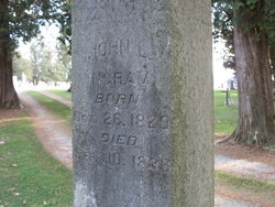
| Burial | : | Mount Hope Cemetery, Lebanon, Smith County, USA |
| Coordinate | : | 39.9721800, -98.5799700 |
| Description | : | Smith County Pioneer – April 2, 1903 Obituary Died, Sabbath morning about one o'clock, March 22, 1903, Cornelius Ingram. He was lain away to rest in the Mt. Hope cemetery March 24th. So He gives His loved ones rest. The subject of this sketch was in his 71st year. He was a member of the Christian church and has been a faithful worker in the vineyard for many years. Truly the harvest is great and laborers few, but Brother Ingram has done what he could. He organized a Sabbath school at the Johnson school house about... Read More |
frequently asked questions (FAQ):
-
Where is Cornelius Machihian Ingram's memorial?
Cornelius Machihian Ingram's memorial is located at: Mount Hope Cemetery, Lebanon, Smith County, USA.
-
When did Cornelius Machihian Ingram death?
Cornelius Machihian Ingram death on 22 Mar 1903 in Smith County, Kansas, USA
-
Where are the coordinates of the Cornelius Machihian Ingram's memorial?
Latitude: 39.9721800
Longitude: -98.5799700
Family Members:
Parent

Spouse
Siblings
Children
Flowers:


Nearby Cemetories:
1. Oriole Cemetery
Lebanon, Smith County, USA
Coordinate: 39.9366400, -98.5938300
2. Gust Cemetery
Webster County, USA
Coordinate: 40.0172005, -98.5421982
3. Webb Hill Cemetery
Lebanon, Smith County, USA
Coordinate: 39.9520200, -98.5045200
4. Mount Pleasant Cemetery
Webster County, USA
Coordinate: 40.0491982, -98.6125031
5. Pleasant Plains Cemetery
Lebanon, Smith County, USA
Coordinate: 39.8793400, -98.5419400
6. Womer Cemetery
Womer, Smith County, USA
Coordinate: 39.9736400, -98.7110800
7. Cedar Hill Cemetery
Cora, Smith County, USA
Coordinate: 39.8863200, -98.6550000
8. Amity Cemetery
Jewell County, USA
Coordinate: 39.9153170, -98.4673780
9. Murphy Cemetery
Red Cloud, Webster County, USA
Coordinate: 40.0744019, -98.5522003
10. Miner Ranch Cemetery
Red Cloud, Webster County, USA
Coordinate: 40.0774500, -98.5733500
11. Walnut Creek Cemetery
Inavale, Webster County, USA
Coordinate: 40.0463982, -98.6793976
12. Old Highland Township Cemetery
Jewell County, USA
Coordinate: 39.9430600, -98.4458900
13. Salem Cemetery
Esbon, Jewell County, USA
Coordinate: 39.8755989, -98.5006027
14. Highland Cemetery
Jewell County, USA
Coordinate: 39.9660988, -98.4300003
15. Sacred Heart Cemetery
Red Cloud, Webster County, USA
Coordinate: 40.0807300, -98.5286700
16. Red Cloud Cemetery
Red Cloud, Webster County, USA
Coordinate: 40.0806961, -98.5270920
17. Wagoner Cemetery
Red Cloud, Webster County, USA
Coordinate: 40.0307999, -98.4488983
18. Oak Hill Cemetery
Lebanon, Smith County, USA
Coordinate: 39.8437010, -98.6186200
19. Martin Cemetery
Webster County, USA
Coordinate: 40.0606003, -98.4518967
20. Spring Vale Cemetery
Washington Township, Smith County, USA
Coordinate: 39.9154700, -98.7424900
21. Northbranch Friends Cemetery
Northbranch, Jewell County, USA
Coordinate: 39.9728300, -98.3708300
22. Oak Creek Cemetery
Jewell County, USA
Coordinate: 39.9014015, -98.3918991
23. Providence Cemetery
Jewell County, USA
Coordinate: 39.8866997, -98.4008026
24. Prairie Home Cemetery
Esbon, Jewell County, USA
Coordinate: 39.8278008, -98.4661026