Corp Joel Hurt
| Birth | : | 10 Jul 1815 Virginia, USA |
| Death | : | 19 Aug 1885 Adair County, Kentucky, USA |
| Burial | : | Holy Trinity Churchyard, Skipton, Craven District, England |
| Coordinate | : | 53.9633250, -2.0161180 |
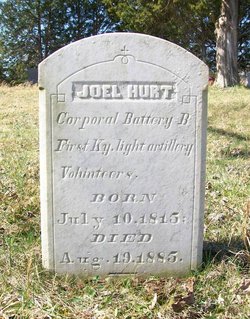
| Inscription | : | Corporal, Battery B First Ky. light artillery Volunteers. |
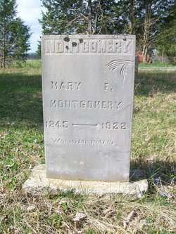
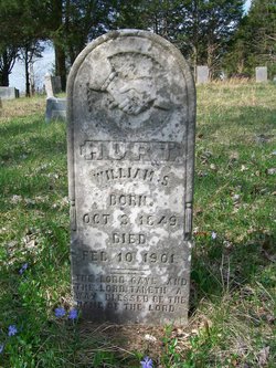
| Description | : | Joel was a son of Alban Hurt and Martha Meeky Montgomery. He was a farmer and a teamster. He married Mary Ann Cabbell on June 18, 1842 in Adair Co., KY and had nine children: George J., Mary Fannie, Hettie J., William S., Edward Y., Sarah Lucinda, Sophia E., Mollie A., and Dollie. He enlisted as a Private in the Union Army and was mustered into the 3rd KY Infantry Co. D on Sep 1, 1861, at age 46. His Company was attached to Independent Battery B, 1st KY Light Artillery on Oct 8, 1861. He was... Read More |
frequently asked questions (FAQ):
-
Where is Corp Joel Hurt's memorial?
Corp Joel Hurt's memorial is located at: Holy Trinity Churchyard, Skipton, Craven District, England.
-
When did Corp Joel Hurt death?
Corp Joel Hurt death on 19 Aug 1885 in Adair County, Kentucky, USA
-
Where are the coordinates of the Corp Joel Hurt's memorial?
Latitude: 53.9633250
Longitude: -2.0161180
Family Members:
Spouse
Children
Flowers:
Nearby Cemetories:
1. Holy Trinity Churchyard
Skipton, Craven District, England
Coordinate: 53.9633250, -2.0161180
2. Skipton War Memorial
Skipton, Craven District, England
Coordinate: 53.9627100, -2.0161680
3. Raikes Road Burial Ground
Skipton, Craven District, England
Coordinate: 53.9643822, -2.0196819
4. St. Andrew's Churchyard
Skipton, Craven District, England
Coordinate: 53.9609959, -2.0140994
5. St Stephen Roman Catholic Churchyard
Skipton, Craven District, England
Coordinate: 53.9631760, -2.0210240
6. Friends Burial Ground at Skipton
Skipton, Craven District, England
Coordinate: 53.9599220, -2.0148630
7. Christ Churchyard
Skipton, Craven District, England
Coordinate: 53.9581200, -2.0188910
8. Tarn Moor Memorial Woodland Burial Ground
Skipton, Craven District, England
Coordinate: 53.9759590, -2.0254260
9. Waltonwrays Cemetery and Skipton Crematorium
Skipton, Craven District, England
Coordinate: 53.9505500, -2.0272300
10. St Mary the Virgin Churchyard
Carleton, Craven District, England
Coordinate: 53.9442300, -2.0417800
11. St Mary Churchyard
Embsay, Craven District, England
Coordinate: 53.9829390, -1.9834030
12. Bradley Cemetery
Bradleys Both, Craven District, England
Coordinate: 53.9306747, -1.9907120
13. St. John's Churchyard
Cononley, Craven District, England
Coordinate: 53.9187890, -2.0212930
14. All Saints Churchyard
Broughton, Craven District, England
Coordinate: 53.9492880, -2.1019580
15. St Andrew Churchyard
Gargrave, Craven District, England
Coordinate: 53.9811830, -2.1054420
16. St Andrew Churchyard
Kildwick, Craven District, England
Coordinate: 53.9091560, -1.9839700
17. Christ Churchyard
Lothersdale, Craven District, England
Coordinate: 53.9097000, -2.0578600
18. Bethel Chapel Cemetery
Lothersdale, Craven District, England
Coordinate: 53.9102184, -2.0749640
19. St Peter Churchyard
Rylstone, Craven District, England
Coordinate: 54.0253360, -2.0445780
20. St James Churchyard
Silsden, Metropolitan Borough of Bradford, England
Coordinate: 53.9139070, -1.9390650
21. Cowling Hill Baptist Cemetery
Cowling, Craven District, England
Coordinate: 53.8961550, -2.0536900
22. St. Thomas's Churchyard
Sutton-in-Craven, Craven District, England
Coordinate: 53.8937020, -1.9906290
23. Silsden Cemetery
Silsden, Metropolitan Borough of Bradford, England
Coordinate: 53.9106500, -1.9267000
24. St. Peter's Churchyard
Martons Both, Craven District, England
Coordinate: 53.9522064, -2.1413111


