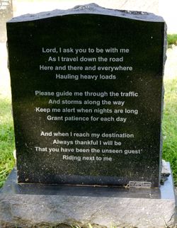
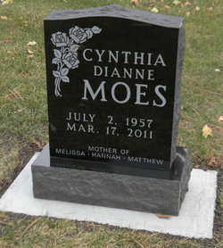
Cynthia Dianne “Cindy” Taken Moes
| Birth | : | 2 Jul 1957 Watertown, Codington County, South Dakota, USA |
| Death | : | 17 Mar 2011 Sioux Falls, Minnehaha County, South Dakota, USA |
| Burial | : | Beaver Falls New Cemetery, Beaver Falls, Lewis County, USA |
| Coordinate | : | 43.8871390, -75.4400280 |
| Description | : | Cindy D. Moes, of Henry, died Mar 17, 2011, in a hospital at Sioux Falls. Honorary pallbearers will be her grandchildren. Active pallbearers will be Mike Buschenfeld, Mark Buschenfeld, Cole Taken, Joe Salisbury, Dale Carda and Mike Morgan. Cynthia "Cindy" Dianne Moes was born July 2, 1957, to Glen H. and Thelma (Toering) Taken in Watertown. She attended school in Watertown and graduated from Watertown High School in 1975. She attended Lake Area Vocational School for medical assisting. She married Charles Decker Dec. 6, 1975. She married Randy Jurgens. On Feb 23, 1991, she married Jim Moes. She was employed at the Guest House in... Read More |
frequently asked questions (FAQ):
-
Where is Cynthia Dianne “Cindy” Taken Moes's memorial?
Cynthia Dianne “Cindy” Taken Moes's memorial is located at: Beaver Falls New Cemetery, Beaver Falls, Lewis County, USA.
-
When did Cynthia Dianne “Cindy” Taken Moes death?
Cynthia Dianne “Cindy” Taken Moes death on 17 Mar 2011 in Sioux Falls, Minnehaha County, South Dakota, USA
-
Where are the coordinates of the Cynthia Dianne “Cindy” Taken Moes's memorial?
Latitude: 43.8871390
Longitude: -75.4400280
Family Members:
Parent
Siblings
Flowers:
Nearby Cemetories:
1. Beaver Falls New Cemetery
Beaver Falls, Lewis County, USA
Coordinate: 43.8871390, -75.4400280
2. Riverside Cemetery
Beaver Falls, Lewis County, USA
Coordinate: 43.8854170, -75.4271670
3. Basselin Cemetery
Croghan, Lewis County, USA
Coordinate: 43.8944016, -75.3921967
4. Naumburg Mennonite Cemetery
Castorland, Lewis County, USA
Coordinate: 43.9011240, -75.4912660
5. Croghan Apostolic Christian Cemetery
Croghan, Lewis County, USA
Coordinate: 43.8688090, -75.3914670
6. Amish Zehr Cemetery
Croghan, Lewis County, USA
Coordinate: 43.8976600, -75.3864880
7. Saint Stephens Cemetery
Croghan, Lewis County, USA
Coordinate: 43.9011002, -75.3855972
8. Union Cemetery
Naumburg, Lewis County, USA
Coordinate: 43.9061012, -75.5008011
9. First Mennonite Church Cemetery
New Bremen, Lewis County, USA
Coordinate: 43.8398460, -75.4262460
10. New Bremen Rural Cemetery
New Bremen, Lewis County, USA
Coordinate: 43.8376100, -75.4422400
11. Saint Peters Catholic Cemetery
New Bremen, Lewis County, USA
Coordinate: 43.8388000, -75.4220900
12. Crystal Light Mennonite Church Cemetery
New Bremen, Lewis County, USA
Coordinate: 43.8358530, -75.4416550
13. Castorland Village Cemetery
Lewis County, USA
Coordinate: 43.8848410, -75.5144730
14. Naumburg Evangelical Baptist Cemetery
Naumburg, Lewis County, USA
Coordinate: 43.9119220, -75.5088190
15. Reed Fairwood Cemetery
Castorland, Lewis County, USA
Coordinate: 43.8514330, -75.5187330
16. Croghan Mennonite Cemetery
Lewis County, USA
Coordinate: 43.8949200, -75.3341700
17. Kirschnerville Cemetery
Kirschnerville, Lewis County, USA
Coordinate: 43.8948910, -75.3340000
18. Stowe Square Cemetery
Lowville, Lewis County, USA
Coordinate: 43.8292900, -75.5141100
19. Gospel Hall Cemetery
Belfort, Lewis County, USA
Coordinate: 43.9248900, -75.3361800
20. Seventh-Day Baptists Settlement Cemetery
Watson, Lewis County, USA
Coordinate: 43.8108330, -75.3883330
21. Hillside Cemetery
Denmark, Lewis County, USA
Coordinate: 43.8774986, -75.5599976
22. Ebblie Cemetery
Lowville, Lewis County, USA
Coordinate: 43.8078003, -75.4897003
23. Saint Vincent dePaul Cemetery
Belfort, Lewis County, USA
Coordinate: 43.9297300, -75.3323000
24. Sunnyside Cemetery
Lewis County, USA
Coordinate: 43.9441986, -75.5492020


