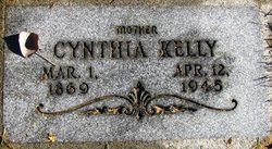
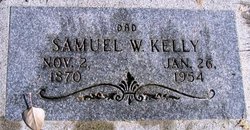
Cynthia Rice Kelly
| Birth | : | 1 Mar 1869 Magoffin County, Kentucky, USA |
| Death | : | 12 Apr 1945 Wenatchee, Chelan County, Washington, USA |
| Burial | : | Oak Grove Cemetery, Marion, McDowell County, USA |
| Coordinate | : | 35.6768990, -81.9966965 |
| Inscription | : | Mother |
| Description | : | Washington Death Certificate Name: Cynthia Kelly Death Date: 10 Apr 1945 Death Place: Wenatchee, Chelan, Washington Gender: Female Age at Death: 76 years 1 month 11 days Estimated Birth Year: 1869 Marital Status: Married Spouse's Name: S W Kelly Father's Name: Clay Rice Mother's Name: Julia Vanderpool Film Number: 2032473 Digital GS Number: 4223011 Image Number: 2070 Volume/Page/Certificate Number: cn 64 |
frequently asked questions (FAQ):
-
Where is Cynthia Rice Kelly's memorial?
Cynthia Rice Kelly's memorial is located at: Oak Grove Cemetery, Marion, McDowell County, USA.
-
When did Cynthia Rice Kelly death?
Cynthia Rice Kelly death on 12 Apr 1945 in Wenatchee, Chelan County, Washington, USA
-
Where are the coordinates of the Cynthia Rice Kelly's memorial?
Latitude: 35.6768990
Longitude: -81.9966965
Family Members:
Spouse
Children
Flowers:
Nearby Cemetories:
1. Oak Grove Cemetery
Marion, McDowell County, USA
Coordinate: 35.6768990, -81.9966965
2. Morehead Cemetery
Marion, McDowell County, USA
Coordinate: 35.6787420, -81.9956450
3. Duncan Family Cemetery
Marion, McDowell County, USA
Coordinate: 35.6791540, -82.0011160
4. Saint John's Episcopal Church Columbarium
Marion, McDowell County, USA
Coordinate: 35.6793360, -82.0058020
5. Elhannon Cemetery
Marion, McDowell County, USA
Coordinate: 35.6861350, -81.9924160
6. Old Marion Methodist Episcopal Church Cemetery
McDowell County, USA
Coordinate: 35.6856260, -82.0063220
7. First United Methodist Church Columbarium
Marion, McDowell County, USA
Coordinate: 35.6917680, -82.0063040
8. Cross Mill Cemetery
Marion, McDowell County, USA
Coordinate: 35.6736341, -82.0221047
9. Chapel Hill Cemetery
Marion, McDowell County, USA
Coordinate: 35.6613998, -81.9756012
10. West Marion United Methodist Church Cemetery
Marion, McDowell County, USA
Coordinate: 35.6609920, -82.0235890
11. Redman Cemetery
McDowell County, USA
Coordinate: 35.7036170, -81.9832490
12. Barnes Cemetery
McDowell County, USA
Coordinate: 35.6567440, -81.9692870
13. McDowell Memorial Park
East Marion, McDowell County, USA
Coordinate: 35.7042007, -81.9775009
14. Solid Rock Free Will Baptist Church Cemetery
Marion, McDowell County, USA
Coordinate: 35.6693120, -81.9589280
15. Proctor-Henline Cemetery
Marion, McDowell County, USA
Coordinate: 35.7047030, -82.0192750
16. Pleasant Hill United Methodist Church Cemetery
Marion, McDowell County, USA
Coordinate: 35.6677690, -81.9572040
17. Mount Calvary Free Will Baptist Church Cemetery
McDowell County, USA
Coordinate: 35.6617550, -82.0401430
18. Murphys Chapel Cemetery
McDowell County, USA
Coordinate: 35.7086980, -81.9664990
19. Bethel Free Will Baptist Church Cemetery
Marion, McDowell County, USA
Coordinate: 35.7070920, -81.9578930
20. Marion Moose Family Center Memorial Garden
Nebo, McDowell County, USA
Coordinate: 35.7156600, -81.9712580
21. Ridgeway Freewill Baptist Church Cemetery
McDowell County, USA
Coordinate: 35.6319070, -82.0010530
22. Revis Cemetery
McDowell County, USA
Coordinate: 35.6753740, -81.9410790
23. Round Hill Baptist Church Cemetery
McDowell County, USA
Coordinate: 35.7050620, -82.0468440
24. Faith Mission Baptist Church Cemetery
McDowell County, USA
Coordinate: 35.6653820, -81.9352920


