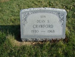
Dale Anthony Crawford
| Birth | : | 16 Jul 1926 Lick Creek Township, Van Buren County, Iowa, USA |
| Death | : | 20 Jul 1964 Fort Riley, Geary County, Kansas, USA |
| Burial | : | Evergreen Cemetery, Fairfield, Jefferson County, USA |
| Coordinate | : | 41.0138600, -91.9562100 |
| Plot | : | 4th.053 |
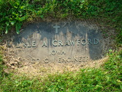
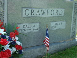
| Inscription | : | The inscription name order is "Dale A.", evidently for Dale Anthony Crawford. The obits use Anthony Dale Crawford. Not sure which is most correct. |
| Description | : | Fairfield Ledger 21 July 1964 CRAWFORD Body Being Returned The remains of Sgt. Anthony Dale CRAWFORD, former Libertyville resident who passed away Monday morning at Ft. Riley, Kan., will arrive in Fairfield Wednesday afternoon and will be taken to the Raymond funeral home where services are pending. Sgt. CRAWFORD suffered a heart attack Sunday evening and was taken to the hospital where he died the following morning. ----------------------------------- Fairfield Ledger 22 July 1964 Sgt. CRAWFORD Rites Thursday. Last rites for Sgt. Anthony Dale CRAWFORD will be Held Thursday at 2:30 p.m. at the Raymond Funeral home. Sgt. Crawford died Monday... Read More |
frequently asked questions (FAQ):
-
Where is Dale Anthony Crawford's memorial?
Dale Anthony Crawford's memorial is located at: Evergreen Cemetery, Fairfield, Jefferson County, USA.
-
When did Dale Anthony Crawford death?
Dale Anthony Crawford death on 20 Jul 1964 in Fort Riley, Geary County, Kansas, USA
-
Where are the coordinates of the Dale Anthony Crawford's memorial?
Latitude: 41.0138600
Longitude: -91.9562100
Family Members:
Parent
Spouse
Siblings
Children
Flowers:
Nearby Cemetories:
1. Evergreen Cemetery
Fairfield, Jefferson County, USA
Coordinate: 41.0138600, -91.9562100
2. Old Fairfield Cemetery
Fairfield, Jefferson County, USA
Coordinate: 41.0148000, -91.9598000
3. Memorial Lawn Cemetery
Fairfield, Jefferson County, USA
Coordinate: 41.0068000, -91.9805000
4. Switzer Cemetery
Fairfield, Jefferson County, USA
Coordinate: 41.0368996, -91.9096985
5. Bradshaw Cemetery
Jefferson County, USA
Coordinate: 40.9766998, -91.9032974
6. Roth Cemetery
Fairfield, Jefferson County, USA
Coordinate: 40.9589005, -91.9574966
7. Bethesda Cemetery
Fairfield, Jefferson County, USA
Coordinate: 41.0019000, -91.8796000
8. Smith Family Cemetery
Libertyville, Jefferson County, USA
Coordinate: 40.9972416, -92.0362857
9. Wheeler Cemetery
Jefferson County, USA
Coordinate: 41.0797000, -91.9185500
10. Galliher Cemetery
Glasgow, Jefferson County, USA
Coordinate: 40.9666892, -91.8835038
11. Upper Richwoods Cemetery
Salina, Jefferson County, USA
Coordinate: 41.0602989, -91.8807983
12. Jefferson County Poor Farm Cemetery
Libertyville, Jefferson County, USA
Coordinate: 40.9416900, -91.9996200
13. Perlee Cemetery
Perlee, Jefferson County, USA
Coordinate: 41.0805750, -91.8993380
14. Pattison Cemetery
Fairfield, Jefferson County, USA
Coordinate: 40.9444008, -91.9049988
15. Moorman Cemetery
Fairfield, Jefferson County, USA
Coordinate: 41.0452995, -92.0622025
16. Wright Cemetery
Fairfield, Jefferson County, USA
Coordinate: 40.9524000, -91.8728000
17. Antioch Cemetery
Fairfield, Jefferson County, USA
Coordinate: 41.1002998, -91.9147034
18. Moyer Cemetery
Fairfield, Jefferson County, USA
Coordinate: 41.1046982, -91.9330978
19. Cumberland Cemetery
Jefferson County, USA
Coordinate: 40.9248000, -91.9903000
20. Gregg Cemetery
Jefferson County, USA
Coordinate: 41.0078011, -92.0811005
21. Salina Cemetery
Salina, Jefferson County, USA
Coordinate: 41.0419006, -91.8330994
22. McCleary Cemetery
Jefferson County, USA
Coordinate: 40.9892006, -92.0805969
23. Brooks Cemetery
Jefferson County, USA
Coordinate: 41.0635986, -92.0693970
24. Thompson Cemetery
Jefferson County, USA
Coordinate: 40.9155998, -91.9772034

