

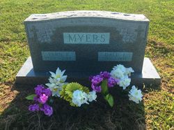
Dale Emblee Myers
| Birth | : | 12 Jul 1910 Courtland, Republic County, Kansas, USA |
| Death | : | 23 Dec 1997 Kansas City, Jackson County, Missouri, USA |
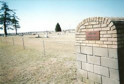
| Burial | : | Huron Cemetery, Huron, Atchison County, USA |
| Coordinate | : | 39.6058006, -95.3585968 |
| Description | : | Dale E. Myers, 87, Kansas City, formerly of Huron, Kan., died Tuesday, Dec. 23, 1997, at his residence. Mr. Myers was a factory worker for the Seabright Manufacturing Co. in Kansas City. Born in Courtland, Kan., on July 12, 1910, he formerly lived in Huron. He was a member of St. Mark's Lutheran Church in Kansas City. Surviving: his wife, the former Fern P. Kuhnert of the home; three grandchildren; three great-grandchildren; and other survivors. Services: Saturday, Dec. 27, 1997, Mark's Lutheran Church, Kansas City. Graveside Service and burial: Huron Cemetery, Huron, Kansas. Arrangements: D.W. Newcomer's Sons Stine & McClure Chapel, Kansas City, MO. Source: St.... Read More |
frequently asked questions (FAQ):
-
Where is Dale Emblee Myers's memorial?
Dale Emblee Myers's memorial is located at: Huron Cemetery, Huron, Atchison County, USA.
-
When did Dale Emblee Myers death?
Dale Emblee Myers death on 23 Dec 1997 in Kansas City, Jackson County, Missouri, USA
-
Where are the coordinates of the Dale Emblee Myers's memorial?
Latitude: 39.6058006
Longitude: -95.3585968
Family Members:
Parent
Spouse
Siblings

Children


Flowers:


Nearby Cemetories:
1. Huron Cemetery
Huron, Atchison County, USA
Coordinate: 39.6058006, -95.3585968
2. Chain Family Cemetery
Huron, Atchison County, USA
Coordinate: 39.6238518, -95.3964767
3. Forest Grove Cemetery
Effingham, Atchison County, USA
Coordinate: 39.5802689, -95.4171524
4. Maple Grove Cemetery
Atchison County, USA
Coordinate: 39.5505981, -95.3597031
5. Lancaster Cemetery
Lancaster, Atchison County, USA
Coordinate: 39.5666275, -95.3054123
6. Anderson Cemetery
Doniphan County, USA
Coordinate: 39.6601700, -95.3214200
7. Miller Cemetery
Everest, Brown County, USA
Coordinate: 39.6866989, -95.3628006
8. Brush Creek Cemetery
Kennekuk, Atchison County, USA
Coordinate: 39.6096992, -95.4702988
9. Saint Marys Cemetery
Doniphan County, USA
Coordinate: 39.6897011, -95.3174973
10. Monrovia Cemetery
Effingham, Atchison County, USA
Coordinate: 39.5150719, -95.3470993
11. Saint Anns Catholic Cemetery
Effingham, Atchison County, USA
Coordinate: 39.5186005, -95.4011002
12. Campbell Cemetery
Farmington, Atchison County, USA
Coordinate: 39.5186900, -95.3145600
13. Effingham Cemetery
Effingham, Atchison County, USA
Coordinate: 39.5152359, -95.3971558
14. Page Cemetery
Brown County, USA
Coordinate: 39.7000600, -95.4015400
15. Good Intent Cemetery
Lancaster, Atchison County, USA
Coordinate: 39.6025009, -95.2275009
16. Saint Louis Cemetery
Good Intent, Atchison County, USA
Coordinate: 39.6241035, -95.2268753
17. Kimberlin Cemetery
Everest, Brown County, USA
Coordinate: 39.7111015, -95.3964005
18. Eden Cemetery (Defunct)
Good Intent, Atchison County, USA
Coordinate: 39.5989300, -95.2163100
19. Kennekuk Cemetery
Horton, Brown County, USA
Coordinate: 39.6533012, -95.4875031
20. Noffsinger Cemetery
Effingham, Atchison County, USA
Coordinate: 39.4924011, -95.3652344
21. Saint Leos Catholic Cemetery
Horton, Brown County, USA
Coordinate: 39.6667595, -95.4889603
22. Robertson Cemetery
Doniphan County, USA
Coordinate: 39.6678009, -95.2277985
23. Wills Cemetery
Muscotah, Atchison County, USA
Coordinate: 39.5596400, -95.5002800
24. All Saints Cemetery
Everest, Brown County, USA
Coordinate: 39.7008018, -95.4507980