
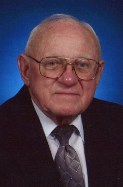
Dale Laverne Koon
| Birth | : | 22 Apr 1924 Clinton County, Iowa, USA |
| Death | : | 9 Jul 2010 Maquoketa, Jackson County, Iowa, USA |
| Burial | : | Riverview Cemetery, Saint Joseph, Berrien County, USA |
| Coordinate | : | 42.0657997, -86.4657974 |
| Description | : | OBITUARY COURTESY OF CARSON & SON FUNERAL & CREMATION SERVICE: Dale L. Koon, 86, of Maquoketa, Iowa, died on Friday morning, July 9, 2010, at Clover Ridge Place in Maquoketa, Iowa. A celebration of his life will be held at 10:30 A.M., Tuesday, July 13, 2010, from the United Church of Christ in Maquoketa, Iowa. Visitation will be held from 4 to 7... Read More |
frequently asked questions (FAQ):
-
Where is Dale Laverne Koon's memorial?
Dale Laverne Koon's memorial is located at: Riverview Cemetery, Saint Joseph, Berrien County, USA.
-
When did Dale Laverne Koon death?
Dale Laverne Koon death on 9 Jul 2010 in Maquoketa, Jackson County, Iowa, USA
-
Where are the coordinates of the Dale Laverne Koon's memorial?
Latitude: 42.0657997
Longitude: -86.4657974
Family Members:
Parent

Flowers:


Nearby Cemetories:
1. Riverview Cemetery
Saint Joseph, Berrien County, USA
Coordinate: 42.0657997, -86.4657974
2. Saint Joseph First UMC Memorial Garden
Saint Joseph, Berrien County, USA
Coordinate: 42.0810930, -86.4909620
3. Highland Cemetery
Saint Joseph, Berrien County, USA
Coordinate: 42.0650980, -86.4987150
4. First Congregational Church UCC Memorial Garden
Saint Joseph, Berrien County, USA
Coordinate: 42.0949790, -86.4842940
5. Hickory Bluff Cemetery
Stevensville, Berrien County, USA
Coordinate: 42.0398670, -86.4952000
6. Spring Run Cemetery
Scottdale, Berrien County, USA
Coordinate: 42.0407600, -86.4348526
7. Saint Joseph City Cemetery
Saint Joseph, Berrien County, USA
Coordinate: 42.0960090, -86.4905980
8. Jerome Cemetery
Saint Joseph, Berrien County, USA
Coordinate: 42.0302699, -86.4758279
9. Resurrection Cemetery
Saint Joseph, Berrien County, USA
Coordinate: 42.0975800, -86.4920883
10. Calvary Cemetery
Benton Harbor, Berrien County, USA
Coordinate: 42.0901820, -86.4196160
11. Temple Beth El Memorial Park
Berrien County, USA
Coordinate: 42.0908660, -86.4154530
12. Crystal Springs Cemetery
Benton Harbor, Berrien County, USA
Coordinate: 42.0918999, -86.4150009
13. B'nai Sholom Cemetery
Fair Plain, Berrien County, USA
Coordinate: 42.0938988, -86.4163971
14. Bethel Cemetery
Sodus, Berrien County, USA
Coordinate: 42.0652770, -86.4013880
15. Lincoln Charter Township Cemetery
Stevensville, Berrien County, USA
Coordinate: 42.0271490, -86.5139110
16. Morton Hill Cemetery
Benton Harbor, Berrien County, USA
Coordinate: 42.1194000, -86.4417038
17. Royalton Cemetery
Saint Joseph, Berrien County, USA
Coordinate: 42.0094365, -86.4249946
18. Pearl Cemetery
Benton Township, Berrien County, USA
Coordinate: 42.0905991, -86.3641968
19. Mount Pleasant Cemetery
Sodus Township, Berrien County, USA
Coordinate: 42.0194016, -86.3581009
20. Feather Cemetery
Hinchman, Berrien County, USA
Coordinate: 41.9720955, -86.4356689
21. Ruggles Cemetery
Baroda, Berrien County, USA
Coordinate: 41.9644012, -86.4906006
22. Shanghai Cemetery
Eau Claire, Berrien County, USA
Coordinate: 42.0378100, -86.3299300
23. Salem Cemetery
Oronoko Township, Berrien County, USA
Coordinate: 41.9644012, -86.4278030
24. Shanghai Memorial Cemetery
Eau Claire, Berrien County, USA
Coordinate: 42.0377560, -86.3288930