
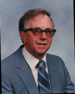
David Edison McCorkle
| Birth | : | 20 Apr 1929 Union County, North Carolina, USA |
| Death | : | 1 Oct 2015 Waxhaw, Union County, North Carolina, USA |
| Burial | : | Bonds Grove United Methodist Church Cemetery, Waxhaw, Union County, USA |
| Coordinate | : | 34.9739609, -80.7715378 |
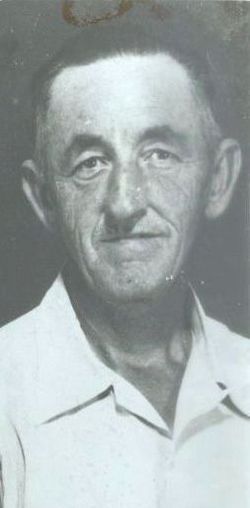
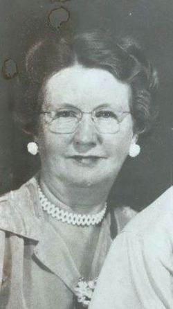
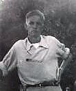
| Description | : | David E. McCorkle, age 86, of Waxhaw, went to be with his Lord and Savior on October 1, 2015. He was born in Union County on April 20, 1929, to the late Clyde and Lottie McCorkle. David was preceded in death by his brother, Clyde McCorkle Jr. He was survived by his daughter, Mona Waters and husband Gary and his son, Ronnie McCorkle and wife Linda. A service to celebrate Mr. McCorkle's life was held 2:00pm Sunday, October 4, 2015, at Bonds Grove United Methodist Church. Burial followed in the church cemetery. Online condolences were offered by visiting www.mcewenmonroechapel.com. Source: Charlotte... Read More |
frequently asked questions (FAQ):
-
Where is David Edison McCorkle's memorial?
David Edison McCorkle's memorial is located at: Bonds Grove United Methodist Church Cemetery, Waxhaw, Union County, USA.
-
When did David Edison McCorkle death?
David Edison McCorkle death on 1 Oct 2015 in Waxhaw, Union County, North Carolina, USA
-
Where are the coordinates of the David Edison McCorkle's memorial?
Latitude: 34.9739609
Longitude: -80.7715378
Family Members:
Parent
Siblings
Flowers:


Nearby Cemetories:
1. Bonds Grove United Methodist Church Cemetery
Waxhaw, Union County, USA
Coordinate: 34.9739609, -80.7715378
2. Redding Springs AME Zion Church Cemetery
Union County, USA
Coordinate: 34.9911919, -80.7594910
3. Marvin AME Zion Church Cemetery
Waxhaw, Union County, USA
Coordinate: 34.9920000, -80.8040000
4. Providence Baptist Church Cemetery
Waxhaw, Union County, USA
Coordinate: 34.9441200, -80.7547200
5. Price Chapel Baptist Church Cemetery
Waxhaw, Union County, USA
Coordinate: 34.9415283, -80.7617188
6. Old Union Methodist Church Cemetery
Union County, USA
Coordinate: 34.9676094, -80.7292023
7. Old Elbethel AME Zion Church Cemetery
Indian Land, Lancaster County, USA
Coordinate: 34.9631250, -80.8125350
8. Saint Margarets Episcopal Church
Waxhaw, Union County, USA
Coordinate: 35.0104310, -80.7781500
9. Marvin United Methodist Church Cemetery
Marvin, Union County, USA
Coordinate: 34.9928894, -80.8166580
10. Union United Methodist Church Cemetery
Union County, USA
Coordinate: 34.9818192, -80.7215424
11. Banks Presbyterian Church Cemetery
Marvin, Union County, USA
Coordinate: 34.9930305, -80.8189697
12. Weddington United Methodist Church Cemetery
Weddington, Union County, USA
Coordinate: 35.0212288, -80.7618332
13. Old Six Mile Cemetery
Indian Land, Lancaster County, USA
Coordinate: 34.9484250, -80.8220320
14. Elbethel AME Zion Church Cemetery
Belair, Lancaster County, USA
Coordinate: 34.9626270, -80.8299860
15. Eastside Community Cemetery
Waxhaw, Union County, USA
Coordinate: 34.9281883, -80.7384415
16. Our Lady of Grace Catholic Church Cemetery
Indian Land, Lancaster County, USA
Coordinate: 34.9191510, -80.7933580
17. Waxhaw City Cemetery
Waxhaw, Union County, USA
Coordinate: 34.9182816, -80.7384415
18. Siler Cemetery
Wesley Chapel, Union County, USA
Coordinate: 34.9955711, -80.6994705
19. Center Grove Memorial Park
Indian Land, Lancaster County, USA
Coordinate: 34.9205500, -80.8122100
20. Belair Methodist Church Cemetery
Lancaster County, USA
Coordinate: 34.9509964, -80.8433228
21. Liberty Hill Church Cemetery
Waxhaw, Union County, USA
Coordinate: 34.9895477, -80.6965332
22. Six Mile Cemetery
Indian Land, Lancaster County, USA
Coordinate: 34.9308014, -80.8319016
23. Pleasant Valley Baptist Church Cemetery
Lancaster County, USA
Coordinate: 34.9931793, -80.8495407
24. Indian Land Baptist Church Cemetery
Indian Land, Lancaster County, USA
Coordinate: 34.9318840, -80.8367260