
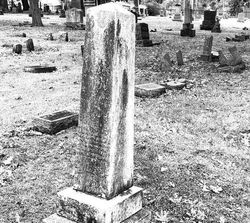
David Starr Hoyt
| Birth | : | 17 Feb 1821 Deerfield, Franklin County, Massachusetts, USA |
| Death | : | 12 Aug 1856 Douglas County, Kansas, USA |
| Burial | : | Pioneer Cemetery, Lawrence, Douglas County, USA |
| Coordinate | : | 38.9528008, -95.2611008 |
| Description | : | From "A genealogical history of the Hoyt, Haight, and Hight families" (1871) by David Webster Hoyt (http://www.archive.org/details/genealogicalhist00hoyt): David Starr (Maj.), b. Feb. 17, 1821 ... After reaching Kansas, he took an active part in the Free State cause, and was selected by the citizens of Lawrence to remonstrate with a company of "border ruffians" under Capt. Saunders, encamped about seven miles distant. Having been assured by U. S. officers that it could be done with perfect safety, he started on his mission alone and unarmed; but his mutilated body, partially buried, was found by a party of his friends the... Read More |
frequently asked questions (FAQ):
-
Where is David Starr Hoyt's memorial?
David Starr Hoyt's memorial is located at: Pioneer Cemetery, Lawrence, Douglas County, USA.
-
When did David Starr Hoyt death?
David Starr Hoyt death on 12 Aug 1856 in Douglas County, Kansas, USA
-
Where are the coordinates of the David Starr Hoyt's memorial?
Latitude: 38.9528008
Longitude: -95.2611008
Family Members:
Flowers:


Nearby Cemetories:
1. Pioneer Cemetery
Lawrence, Douglas County, USA
Coordinate: 38.9528008, -95.2611008
2. First Presbyterian Church Memorial Garden
Lawrence, Douglas County, USA
Coordinate: 38.9414900, -95.2641600
3. Dyche Hall Natural History Museum
Lawrence, Douglas County, USA
Coordinate: 38.9584800, -95.2434800
4. Trinity Episcopal Church Columbarium
Lawrence, Douglas County, USA
Coordinate: 38.9653893, -95.2373886
5. Davis Cemetery
Lawrence, Douglas County, USA
Coordinate: 38.9722500, -95.2831100
6. Haskell Cemetery
Lawrence, Douglas County, USA
Coordinate: 38.9353790, -95.2284241
7. Memorial Park Cemetery
Lawrence, Douglas County, USA
Coordinate: 38.9552994, -95.2153015
8. Mount Calvary Catholic Cemetery
Lawrence, Douglas County, USA
Coordinate: 38.9580002, -95.2139969
9. Oak Hill Cemetery
Lawrence, Douglas County, USA
Coordinate: 38.9589005, -95.2118988
10. Adams Cemetery
Douglas County, USA
Coordinate: 38.9955400, -95.2509100
11. Corpus Christi Catholic Church Columbarium
Lawrence, Douglas County, USA
Coordinate: 38.9572250, -95.3238450
12. Kennedy Cemetery
Douglas County, USA
Coordinate: 38.9112900, -95.2269200
13. Marshall Cemetery
Douglas County, USA
Coordinate: 38.9040800, -95.2446700
14. County Poor Farm Cemetery
Douglas County, USA
Coordinate: 38.9119400, -95.2214600
15. Maple Grove Cemetery
Lawrence, Douglas County, USA
Coordinate: 39.0018997, -95.2316971
16. Saint Johns Catholic Cemetery
Douglas County, USA
Coordinate: 38.9437900, -95.1919600
17. Lyon Family Cemetery
Lawrence, Douglas County, USA
Coordinate: 38.9877440, -95.3166530
18. Dutton Cemetery
Douglas County, USA
Coordinate: 38.8989800, -95.2790600
19. Franklin Cemetery
Douglas County, USA
Coordinate: 38.9437523, -95.1869431
20. Blue Mound Cemetery
Lawrence, Douglas County, USA
Coordinate: 38.9046600, -95.1865400
21. Richland Cemetery
Lawrence, Douglas County, USA
Coordinate: 38.8768997, -95.2630997
22. Lakeview Cemetery
Douglas County, USA
Coordinate: 39.0219100, -95.3164400
23. Jones Cemetery
Lawrence, Douglas County, USA
Coordinate: 38.8936950, -95.3620840
24. Johnson Cemetery
Douglas County, USA
Coordinate: 38.8857700, -95.3545300