

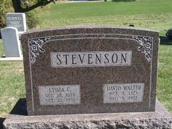
David Walter Stevenson
| Birth | : | 9 Oct 1875 Illinois, USA |
| Death | : | 8 Dec 1952 Denmark, Lee County, Iowa, USA |
| Burial | : | Stanthorpe Cemetery, Stanthorpe, Southern Downs Region, Australia |
| Coordinate | : | -28.6452210, 151.9332990 |
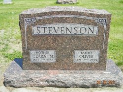
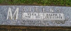
| Description | : | The Evening Democrat, Fort Madison, Iowa, 9 December 1952 D. Stevenson Rites Thursday David Walter Stevenson, 77, died Monday at 7:30 p.m. in his home near Denmark. He had been in failing health for two years. Born 9 October 1875 in Henry county, Illinois, he had lived 46 years in Lee county where he farmed. He was married to Lydia Norberg at Galesburg, Illinois on 21 September 1905. The deceased is survived by one son, Milo, Denmark; one daughter, Mrs. Ralph Mathews, Danville; three brothers, Henry, Muscatine, Oliver, Holbrook, Nebraska and Omar, Bell, California and five grandchildren. Two brothers and four sisters preceded him... Read More |
frequently asked questions (FAQ):
-
Where is David Walter Stevenson's memorial?
David Walter Stevenson's memorial is located at: Stanthorpe Cemetery, Stanthorpe, Southern Downs Region, Australia.
-
When did David Walter Stevenson death?
David Walter Stevenson death on 8 Dec 1952 in Denmark, Lee County, Iowa, USA
-
Where are the coordinates of the David Walter Stevenson's memorial?
Latitude: -28.6452210
Longitude: 151.9332990
Family Members:
Parent
Spouse
Siblings

Children
Flowers:


Nearby Cemetories:
1. Stanthorpe Cemetery
Stanthorpe, Southern Downs Region, Australia
Coordinate: -28.6452210, 151.9332990
2. John Doro
Stanthorpe, Southern Downs Region, Australia
Coordinate: -28.6508250, 151.9208340
3. Strath Elbess Cemetery
Dalveen, Southern Downs Region, Australia
Coordinate: -28.4883070, 151.9692850
4. Dalveen-Mitchell Family Homestead Cemetery
Dalveen, Southern Downs Region, Australia
Coordinate: -28.4423200, 151.9604000
5. Ballandean Station Cemetery
Ballandean, Southern Downs Region, Australia
Coordinate: -28.8196000, 151.7880000
6. Wallangarra Cemetery
Wallangarra, Southern Downs Region, Australia
Coordinate: -28.9189280, 151.9230310
7. Lone Grave Warwick
Warwick, Southern Downs Region, Australia
Coordinate: -28.2316590, 151.9833180
8. Killarney Lawn Cemetery
Killarney, Southern Downs Region, Australia
Coordinate: -28.3475760, 152.2742790
9. Eden Gardens Memorial Park
Warwick, Southern Downs Region, Australia
Coordinate: -28.2229690, 152.0031130
10. St Marks Anglican Church Columbarium Wall
Warwick, Southern Downs Region, Australia
Coordinate: -28.2161000, 152.0347600
11. Warwick General Lawn Cemetery
Warwick, Southern Downs Region, Australia
Coordinate: -28.2106310, 152.0039087
12. Warwick General Cemetery
Warwick, Southern Downs Region, Australia
Coordinate: -28.2100890, 152.0044080
13. Warwick War Cemetery
Warwick, Southern Downs Region, Australia
Coordinate: -28.2089620, 152.0033530
14. Lone Graves
Coolmunda, Goondiwindi Region, Australia
Coordinate: -28.6256043, 151.4111058
15. Swan Creek Anglican Cemetery
Swan Creek, Southern Downs Region, Australia
Coordinate: -28.1974400, 152.1364830
16. Yangan General and Anglican Cemetery
Emu Vale, Southern Downs Region, Australia
Coordinate: -28.2059990, 152.2207110
17. Yangan Presbyterian Church Cemetery
Yangan, Southern Downs Region, Australia
Coordinate: -28.1972310, 152.2142130
18. Warwick-Conway Family Homestead Cemetery
Warwick, Southern Downs Region, Australia
Coordinate: -28.1258400, 152.0395700
19. Arlington Cemetery
Graysholm, Goondiwindi Region, Australia
Coordinate: -28.3259160, 151.4372210
20. Glengallan Station
Warwick, Southern Downs Region, Australia
Coordinate: -28.1027016, 152.0585067
21. Pratten Cemetery
Pratten, Southern Downs Region, Australia
Coordinate: -28.0858450, 151.7790540
22. Old Bonalbo Cemetery
Old Bonalbo, Kyogle Council, Australia
Coordinate: -28.6499996, 152.6000061
23. Bonalbo Cemetery
Bonalbo, Kyogle Council, Australia
Coordinate: -28.7180970, 152.6050560
24. Tabulam Cemetery
Tabulam, Kyogle Council, Australia
Coordinate: -28.9078060, 152.5581050