


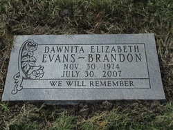

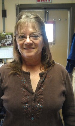
Dawnita Elizabeth “Dawn” Evans Brandon
| Birth | : | 30 Nov 1974 Lawrence, Douglas County, Kansas, USA |
| Death | : | 30 Jul 2007 Rock Springs, Sweetwater County, Wyoming, USA |
| Burial | : | Oak Hill Cemetery, Lawrence, Douglas County, USA |
| Coordinate | : | 38.9589005, -95.2118988 |
| Plot | : | Section 16, lot 101, grave 2 |
| Inscription | : | WE WILL REMEMBER |
| Description | : | From silent witnesses: DAWNITA ELIZABETH EVANS BRANDON Age 32 July 30, 2007 Rock Springs, Wyoming Dawnita was brutally murdered from stab wounds inflicted on her by her husband, she was 32. Dawnita was born November 30, 1974, in Lawrence Kansas. She moved to Rock Springs in 2005 where she met her husband Timothy Brandon. Dawnita was a very vibrant, beautiful woman, she loved the outdoors, fishing, camping and spending time with family and friends. Her goal in life was to be someone everyone could be proud of, and we... Read More |
frequently asked questions (FAQ):
-
Where is Dawnita Elizabeth “Dawn” Evans Brandon's memorial?
Dawnita Elizabeth “Dawn” Evans Brandon's memorial is located at: Oak Hill Cemetery, Lawrence, Douglas County, USA.
-
When did Dawnita Elizabeth “Dawn” Evans Brandon death?
Dawnita Elizabeth “Dawn” Evans Brandon death on 30 Jul 2007 in Rock Springs, Sweetwater County, Wyoming, USA
-
Where are the coordinates of the Dawnita Elizabeth “Dawn” Evans Brandon's memorial?
Latitude: 38.9589005
Longitude: -95.2118988
Family Members:
Parent
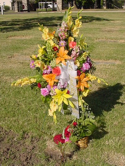
Flowers:


Nearby Cemetories:
1. Oak Hill Cemetery
Lawrence, Douglas County, USA
Coordinate: 38.9589005, -95.2118988
2. Mount Calvary Catholic Cemetery
Lawrence, Douglas County, USA
Coordinate: 38.9580002, -95.2139969
3. Memorial Park Cemetery
Lawrence, Douglas County, USA
Coordinate: 38.9552994, -95.2153015
4. Trinity Episcopal Church Columbarium
Lawrence, Douglas County, USA
Coordinate: 38.9653893, -95.2373886
5. Saint Johns Catholic Cemetery
Douglas County, USA
Coordinate: 38.9437900, -95.1919600
6. Dyche Hall Natural History Museum
Lawrence, Douglas County, USA
Coordinate: 38.9584800, -95.2434800
7. Franklin Cemetery
Douglas County, USA
Coordinate: 38.9437523, -95.1869431
8. Haskell Cemetery
Lawrence, Douglas County, USA
Coordinate: 38.9353790, -95.2284241
9. Pioneer Cemetery
Lawrence, Douglas County, USA
Coordinate: 38.9528008, -95.2611008
10. First Presbyterian Church Memorial Garden
Lawrence, Douglas County, USA
Coordinate: 38.9414900, -95.2641600
11. Maple Grove Cemetery
Lawrence, Douglas County, USA
Coordinate: 39.0018997, -95.2316971
12. County Poor Farm Cemetery
Douglas County, USA
Coordinate: 38.9119400, -95.2214600
13. Adams Cemetery
Douglas County, USA
Coordinate: 38.9955400, -95.2509100
14. Kennedy Cemetery
Douglas County, USA
Coordinate: 38.9112900, -95.2269200
15. Davis Cemetery
Lawrence, Douglas County, USA
Coordinate: 38.9722500, -95.2831100
16. Blue Mound Cemetery
Lawrence, Douglas County, USA
Coordinate: 38.9046600, -95.1865400
17. Marshall Cemetery
Douglas County, USA
Coordinate: 38.9040800, -95.2446700
18. Dutton Cemetery
Douglas County, USA
Coordinate: 38.8989800, -95.2790600
19. Luckan Family Cemetery
Fall Leaf, Leavenworth County, USA
Coordinate: 38.9808500, -95.1128000
20. Cemetery Beni Israel
Eudora, Douglas County, USA
Coordinate: 38.9280128, -95.1122208
21. Southwest City Cemetery
Eudora, Douglas County, USA
Coordinate: 38.9334800, -95.1070300
22. Lyon Family Cemetery
Lawrence, Douglas County, USA
Coordinate: 38.9877440, -95.3166530
23. Corpus Christi Catholic Church Columbarium
Lawrence, Douglas County, USA
Coordinate: 38.9572250, -95.3238450
24. Richland Cemetery
Lawrence, Douglas County, USA
Coordinate: 38.8768997, -95.2630997