
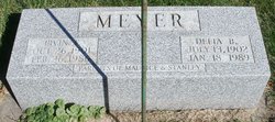

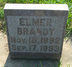
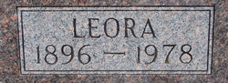
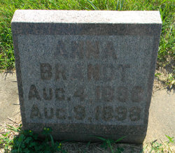
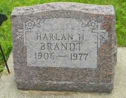
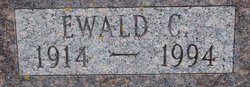
Delia Bertha Brandt Meyer
| Birth | : | 13 Jul 1902 Iowa, USA |
| Death | : | 18 Jan 1989 |
| Burial | : | Giard Cemetery, Farmersburg, Clayton County, USA |
| Coordinate | : | 42.9933014, -91.3080978 |
| Description | : | Delia Bertha Brandt Meyer died Wednesday, Jan. 18, 1989, at the Great River Care Center in McGregor where she had been a resident since 1976. She had been in poor health, having suffered a stroke at her home on March 18, 1973. Funeral services were held Saturday, January 21, 11 a.m., at Giard United Methodist Church, Giard. Rev. Gary Dobbins officiated. Organist was Mrs. Harry Larson. Burial was in the Giard Cemetery, rural Farmersburg. She was born July 13, 1902, near Postville to parents Fred and Minnie Meyer Brandt. She was baptized and confirmed in the Lutheran Church at Postville. She graduated... Read More |
frequently asked questions (FAQ):
-
Where is Delia Bertha Brandt Meyer's memorial?
Delia Bertha Brandt Meyer's memorial is located at: Giard Cemetery, Farmersburg, Clayton County, USA.
-
When did Delia Bertha Brandt Meyer death?
Delia Bertha Brandt Meyer death on 18 Jan 1989 in
-
Where are the coordinates of the Delia Bertha Brandt Meyer's memorial?
Latitude: 42.9933014
Longitude: -91.3080978
Family Members:
Parent
Spouse
Siblings
Children
Flowers:


Nearby Cemetories:
1. Giard Cemetery
Farmersburg, Clayton County, USA
Coordinate: 42.9933014, -91.3080978
2. Bismark Cemetery
Farmersburg, Clayton County, USA
Coordinate: 42.9790000, -91.3500000
3. Railroad Employee Cemetery
Giard, Clayton County, USA
Coordinate: 43.0305395, -91.3140229
4. National Cemetery
National, Clayton County, USA
Coordinate: 42.9536018, -91.2902985
5. Farmersburg-Wagner Cemetery
Farmersburg, Clayton County, USA
Coordinate: 42.9481010, -91.3700027
6. Eastman Cemetery
McGregor, Clayton County, USA
Coordinate: 43.0010000, -91.2190000
7. Saint Wenceslaus Cemetery
McGregor, Clayton County, USA
Coordinate: 43.0593987, -91.3142014
8. Council Hill Cemetery
Monona, Clayton County, USA
Coordinate: 43.0718994, -91.3000031
9. Saint Paul Lutheran Cemetery
Monona, Clayton County, USA
Coordinate: 43.0494385, -91.3847198
10. Saint Patricks Cemetery
Monona, Clayton County, USA
Coordinate: 43.0496000, -91.3850000
11. Monona Cemetery
Monona, Clayton County, USA
Coordinate: 43.0531006, -91.3799973
12. Gooding Cemetery
Wagner Township, Clayton County, USA
Coordinate: 42.9869490, -91.4191570
13. Buell Park Cemetery
Mendon Township, Clayton County, USA
Coordinate: 43.0168226, -91.1999590
14. Moody Cemetery
McGregor, Clayton County, USA
Coordinate: 43.0030594, -91.1886063
15. Pleasant Grove Cemetery
McGregor, Clayton County, USA
Coordinate: 43.0266991, -91.1949997
16. Pioneer Cemetery
Monona, Clayton County, USA
Coordinate: 43.0149994, -91.4274979
17. Walton Cemetery
McGregor, Clayton County, USA
Coordinate: 43.0216270, -91.1909350
18. Knapp Cemetery
McGregor, Clayton County, USA
Coordinate: 43.0635000, -91.2213000
19. Saint Marys Catholic Church Cemetery
McGregor, Clayton County, USA
Coordinate: 43.0213735, -91.1834632
20. First Evangelical Lutheran Church Cemetery
McGregor, Clayton County, USA
Coordinate: 42.9718000, -91.1760000
21. Norwegian Church Cemetery
McGregor, Clayton County, USA
Coordinate: 42.9644400, -91.1764100
22. County Home Cemetery
Clayton Center, Clayton County, USA
Coordinate: 42.8916702, -91.3499985
23. Norway Lutheran Church Cemetery
Saint Olaf, Clayton County, USA
Coordinate: 42.9352798, -91.4302826
24. Baylis Cemetery
McGregor, Clayton County, USA
Coordinate: 43.0633160, -91.1959630