

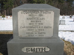
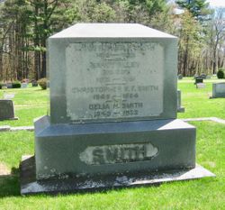
Delia M. Smith
| Birth | : | 1849 New Hampshire, USA |
| Death | : | 1932 USA |
| Burial | : | Salem Cemetery, Lomira, Dodge County, USA |
| Coordinate | : | 43.5872530, -88.4463790 |
| Description | : | The 1870 Federal Census lists her name as "Adelia". Her occupation is shown as Schoolteacher. -------------------------------------------- The town record lists her as the wife of Calvin R. Wood. |
frequently asked questions (FAQ):
-
Where is Delia M. Smith's memorial?
Delia M. Smith's memorial is located at: Salem Cemetery, Lomira, Dodge County, USA.
-
When did Delia M. Smith death?
Delia M. Smith death on 1932 in USA
-
Where are the coordinates of the Delia M. Smith's memorial?
Latitude: 43.5872530
Longitude: -88.4463790
Family Members:
Parent

Siblings


Flowers:


Nearby Cemetories:
1. Salem Cemetery
Lomira, Dodge County, USA
Coordinate: 43.5872530, -88.4463790
2. Saint Johns Lutheran Cemetery
Lomira, Dodge County, USA
Coordinate: 43.5877266, -88.4469833
3. Saint Marys Cemetery
Lomira, Dodge County, USA
Coordinate: 43.5903015, -88.4518967
4. Old Community Cemetery
Lomira, Dodge County, USA
Coordinate: 43.6086590, -88.4499060
5. Ebenezer Cemetery
Lomira, Dodge County, USA
Coordinate: 43.6156006, -88.4210968
6. Saint Pauls Evangelical Lutheran Cemetery
Lomira, Dodge County, USA
Coordinate: 43.5510050, -88.4430740
7. Emanuel Cemetery
Knowles, Dodge County, USA
Coordinate: 43.5877991, -88.4997025
8. Saint Pauls Evangelical Lutheran Cemetery
Brownsville, Dodge County, USA
Coordinate: 43.6167200, -88.4889100
9. Saint Luke Evangelical Lutheran Church Cemetery
Knowles, Dodge County, USA
Coordinate: 43.5718720, -88.5016540
10. Brownsville Community Cemetery
Brownsville, Dodge County, USA
Coordinate: 43.5995380, -88.5053440
11. Saint Martin's Catholic Cemetery
Ashford, Fond du Lac County, USA
Coordinate: 43.5855598, -88.3730011
12. Saint Peters Cemetery
Theresa, Dodge County, USA
Coordinate: 43.5367012, -88.4794006
13. Union Cemetery
Theresa, Dodge County, USA
Coordinate: 43.5261002, -88.4514008
14. Wayne Cemetery
Wayne, Washington County, USA
Coordinate: 43.5402985, -88.3910980
15. Mount Pleasant Cemetery
LeRoy, Dodge County, USA
Coordinate: 43.6167800, -88.5263000
16. Rohlf Cemetery
Eden, Fond du Lac County, USA
Coordinate: 43.6313460, -88.3804180
17. Saint Theresa Memorial Gardens Cemetery
Theresa, Dodge County, USA
Coordinate: 43.5182800, -88.4468500
18. Byron Cemetery
Byron, Fond du Lac County, USA
Coordinate: 43.6572189, -88.4505615
19. Saint Kilian Cemetery
Saint Kilian, Fond du Lac County, USA
Coordinate: 43.5455589, -88.3600006
20. Saint Andrews Church Cemetery
LeRoy, Dodge County, USA
Coordinate: 43.5732994, -88.5500336
21. Saint Gobki Cemetery
Theresa, Dodge County, USA
Coordinate: 43.5144005, -88.4803009
22. Deutsche Bisch Methodist Kirche Cemetery
Ashford, Fond du Lac County, USA
Coordinate: 43.5653000, -88.3352966
23. Genesee Cemetery
Byron, Fond du Lac County, USA
Coordinate: 43.6613884, -88.5066681
24. Saint John Catholic Cemetery
Byron, Fond du Lac County, USA
Coordinate: 43.6744400, -88.4501000