
| Birth | : | 3 Sep 1910 Iona, Lyman County, South Dakota, USA |
| Death | : | 4 Jan 2004 Clear Lake, Cerro Gordo County, Iowa, USA |
| Burial | : | All Saints Churchyard, Freshwater, Isle of Wight Unitary Authority, England |
| Coordinate | : | 50.6843570, -1.5102280 |
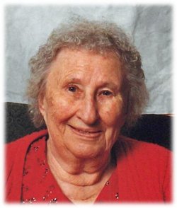
| Description | : | CLEAR LAKE - DeLos James Armstrong, 93, of 901 N. 12th St., passed away Sunday (Jan. 4, 2004) at the Oakwood Care Center in Clear Lake. Interment will be in the Clear Lake Cemetery. DeLos was born Sept. 3, 1910, the son of Harry and Pearl (McCormick) Armstrong in Iona, S.D. Delos moved with his folks, at an early age, to Dows, to the home farm. DeLos was united in marriage to Margaret Smith, March 30, 1930, and they farmed in the Franklin County area. In 1950, they moved to the Clear Lake area,continued to farm and later trucked, hauling... Read More |
frequently asked questions (FAQ):
-
Where is Delos James Armstrong's memorial?
Delos James Armstrong's memorial is located at: All Saints Churchyard, Freshwater, Isle of Wight Unitary Authority, England.
-
When did Delos James Armstrong death?
Delos James Armstrong death on 4 Jan 2004 in Clear Lake, Cerro Gordo County, Iowa, USA
-
Where are the coordinates of the Delos James Armstrong's memorial?
Latitude: 50.6843570
Longitude: -1.5102280
Family Members:
Spouse

Children
Flowers:


Nearby Cemetories:
1. All Saints Churchyard
Freshwater, Isle of Wight Unitary Authority, England
Coordinate: 50.6843570, -1.5102280
2. St Agnes Churchyard
Freshwater, Isle of Wight Unitary Authority, England
Coordinate: 50.6731050, -1.5173550
3. St Saviour Roman Catholic Churchyard
Totland, Isle of Wight Unitary Authority, England
Coordinate: 50.6762700, -1.5410390
4. St James Churchyard
Yarmouth, Isle of Wight Unitary Authority, England
Coordinate: 50.7055370, -1.4991890
5. Christ Church Totland Bay
Totland, Isle of Wight Unitary Authority, England
Coordinate: 50.6760770, -1.5448160
6. St. Swithin's Old Churchyard
Thorley, Isle of Wight Unitary Authority, England
Coordinate: 50.7007450, -1.4815300
7. St. Mary the Virgin Churchyard
Brook, Isle of Wight Unitary Authority, England
Coordinate: 50.6577970, -1.4430340
8. St Peter and St Paul’s Churchyard
Mottistone, Isle of Wight Unitary Authority, England
Coordinate: 50.6517620, -1.4275530
9. St. Michael the Archangel Churchyard
Shalfleet, Isle of Wight Unitary Authority, England
Coordinate: 50.7014300, -1.4156370
10. All Saints Churchyard
Milford-on-Sea, New Forest District, England
Coordinate: 50.7278170, -1.5897770
11. All Saints Churchyard
Calbourne, Isle of Wight Unitary Authority, England
Coordinate: 50.6772990, -1.3996370
12. Holy Spirit Churchyard
Newtown, Isle of Wight Unitary Authority, England
Coordinate: 50.7143690, -1.4035400
13. St. Thomas the Apostle Churchyard
Lymington, New Forest District, England
Coordinate: 50.7576410, -1.5451200
14. St. Mark's Churchyard
Pennington, New Forest District, England
Coordinate: 50.7545700, -1.5631100
15. Calbourne Burial Ground
Calbourne, Isle of Wight Unitary Authority, England
Coordinate: 50.6832007, -1.3864018
16. Lymington Cemetery
Lymington, New Forest District, England
Coordinate: 50.7576200, -1.5576200
17. St. Mary the Virgin Churchyard
Brighstone, Isle of Wight Unitary Authority, England
Coordinate: 50.6422540, -1.3944850
18. St Mary Churchyard
South Baddesley, New Forest District, England
Coordinate: 50.7691430, -1.5026160
19. All Saints Churchyard
Hordle, New Forest District, England
Coordinate: 50.7549400, -1.6136200
20. Porchfield Congregational Cemetery
Porchfield, Isle of Wight Unitary Authority, England
Coordinate: 50.7190660, -1.3679770
21. Ashley Baptist Cemetery
New Milton, New Forest District, England
Coordinate: 50.7529200, -1.6336400
22. St Peter's Parish Church
Shorwell, Isle of Wight Unitary Authority, England
Coordinate: 50.6449290, -1.3545580
23. St Peter New Churchyard
Shorwell, Isle of Wight Unitary Authority, England
Coordinate: 50.6433100, -1.3541400
24. Milford Road Cemetery
New Milton, New Forest District, England
Coordinate: 50.7472700, -1.6502700