

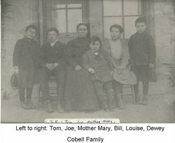
Dewey Phillip Cobell
| Birth | : | Apr 1898 Browning, Glacier County, Montana, USA |
| Death | : | 22 Apr 1960 Meriwether, Glacier County, Montana, USA |
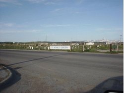
| Burial | : | Ecclesfield Jewish Cemetery, Ecclesfield, Metropolitan Borough of Sheffield, England |
| Coordinate | : | 53.4299600, -1.4637700 |
| Description | : | Not much is known about Dewey. As an adult, he worked for his brother Tom Cobell as ranch hand and sheepherder. In approximately 1959, Tom went out to the sheep camp out on Meriweather and found that Dewey had died in his sleep. It is not known if Dewey was married or had children.* *Additional info will be appreciated. |
frequently asked questions (FAQ):
-
Where is Dewey Phillip Cobell's memorial?
Dewey Phillip Cobell's memorial is located at: Ecclesfield Jewish Cemetery, Ecclesfield, Metropolitan Borough of Sheffield, England.
-
When did Dewey Phillip Cobell death?
Dewey Phillip Cobell death on 22 Apr 1960 in Meriwether, Glacier County, Montana, USA
-
Where are the coordinates of the Dewey Phillip Cobell's memorial?
Latitude: 53.4299600
Longitude: -1.4637700
Family Members:
Parent
Siblings

Flowers:


Nearby Cemetories:
1. Ecclesfield Jewish Cemetery
Ecclesfield, Metropolitan Borough of Sheffield, England
Coordinate: 53.4299600, -1.4637700
2. St. Paul's Churchyard
Sheffield, Metropolitan Borough of Sheffield, England
Coordinate: 53.4333670, -1.4692500
3. St. Mary the Virgin Churchyard
Ecclesfield, Metropolitan Borough of Sheffield, England
Coordinate: 53.4432350, -1.4698510
4. Ecclesfield Cemetery
Ecclesfield, Metropolitan Borough of Sheffield, England
Coordinate: 53.4441210, -1.4719340
5. Shiregreen Cemetery
Sheffield, Metropolitan Borough of Sheffield, England
Coordinate: 53.4212050, -1.4360650
6. Wardsend Cemetery
Sheffield, Metropolitan Borough of Sheffield, England
Coordinate: 53.4086120, -1.4895330
7. Grenoside Crematorium
Grenoside, Metropolitan Borough of Sheffield, England
Coordinate: 53.4375860, -1.5087020
8. St. Thomas' Churchyard
Brightside, Metropolitan Borough of Sheffield, England
Coordinate: 53.4068100, -1.4327000
9. Christ Church Pitsmoor
Sheffield, Metropolitan Borough of Sheffield, England
Coordinate: 53.3969748, -1.4673422
10. Hillsborough Walled Garden Memorials
Hillsborough, Metropolitan Borough of Sheffield, England
Coordinate: 53.4071221, -1.5039054
11. Burngreave Cemetery
Sheffield, Metropolitan Borough of Sheffield, England
Coordinate: 53.3969000, -1.4615000
12. Burncross Cemetery
Burncross, Metropolitan Borough of Sheffield, England
Coordinate: 53.4631420, -1.4796780
13. Holy Trinity Churchyard
Thorpe Hesley, Metropolitan Borough of Rotherham, England
Coordinate: 53.4595020, -1.4317560
14. Hillsborough Barracks Chapel Courtyard
Hillsborough, Metropolitan Borough of Sheffield, England
Coordinate: 53.4013100, -1.4980900
15. St. John the Baptist Churchyard
Chapeltown, Metropolitan Borough of Sheffield, England
Coordinate: 53.4651830, -1.4716260
16. Holy Trinity Churchyard Extension
Thorpe Hesley, Metropolitan Borough of Rotherham, England
Coordinate: 53.4603190, -1.4314840
17. Wadsley Churchyard
Sheffield, Metropolitan Borough of Sheffield, England
Coordinate: 53.4120290, -1.5181790
18. Attercliffe Hilltop Cemetery
Attercliffe, Metropolitan Borough of Sheffield, England
Coordinate: 53.3992340, -1.4264000
19. Attercliffe Municipal Cemetery
Attercliffe, Metropolitan Borough of Sheffield, England
Coordinate: 53.3957050, -1.4317500
20. Christ Church Cemetery Attercliffe
Attercliffe, Metropolitan Borough of Sheffield, England
Coordinate: 53.3955262, -1.4309578
21. Christ Church Churchyard
Attercliffe, Metropolitan Borough of Sheffield, England
Coordinate: 53.3952000, -1.4307000
22. Zion Graveyard
Attercliffe, Metropolitan Borough of Sheffield, England
Coordinate: 53.3944160, -1.4326430
23. St. Philip's Churchyard
Sheffield, Metropolitan Borough of Sheffield, England
Coordinate: 53.3898180, -1.4789820
24. St. Thomas the Apostle Churchyard
Kimberworth, Metropolitan Borough of Rotherham, England
Coordinate: 53.4337400, -1.3936000