
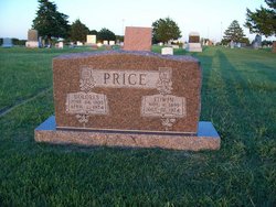
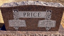
Dolores Conyac Price
| Birth | : | 24 Jun 1905 Damar, Rooks County, Kansas, USA |
| Death | : | 11 Apr 1974 Kansas, USA |
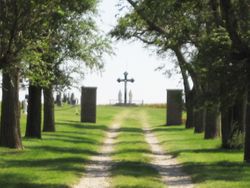
| Burial | : | Mount Hope Cemetery, Clyde, Cloud County, USA |
| Coordinate | : | 39.5969009, -97.4116974 |
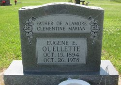
| Description | : | Dolores Conyac was likely to actually have been born on her parents farm in Wild Horse Township of Graham County, Kansas near Damar. She was the daughter of Joseph and Marie-Clementine (Newell) Conyac.After her mother died in 1911 her father Joseph Conyac remarried about 1917 to Julia LaVallie and they all moved to Marshall, Minnesota. Dolores married Eugene Ouellette there in 1921 and they moved back to Kansas. Dolores and Eugene would later divorce. Dolores would then marry Edwin Price before they both died in 1974. FROM THE CLYDE, KANSAS NEWSPAPER; APRIL 18, 1974: MRS. DOLORES PRICE Mrs. Dolores Price, 68, was... Read More |
frequently asked questions (FAQ):
-
Where is Dolores Conyac Price's memorial?
Dolores Conyac Price's memorial is located at: Mount Hope Cemetery, Clyde, Cloud County, USA.
-
When did Dolores Conyac Price death?
Dolores Conyac Price death on 11 Apr 1974 in Kansas, USA
-
Where are the coordinates of the Dolores Conyac Price's memorial?
Latitude: 39.5969009
Longitude: -97.4116974
Family Members:
Parent
Spouse
Siblings
Children
Flowers:


Nearby Cemetories:
1. Mount Calvary Cemetery
Clyde, Cloud County, USA
Coordinate: 39.5917015, -97.4143982
2. Cedar Grove Cemetery
Clyde, Cloud County, USA
Coordinate: 39.5494003, -97.4056015
3. Pleasant View Cemetery
Ames, Cloud County, USA
Coordinate: 39.5346985, -97.4431000
4. Walnut Grove Cemetery
Cloud County, USA
Coordinate: 39.5699997, -97.4993973
5. Agenda Cemetery
Agenda, Republic County, USA
Coordinate: 39.6761017, -97.4336014
6. Saint Joseph Cemetery
Saint Joseph, Cloud County, USA
Coordinate: 39.5074941, -97.4022328
7. Beck Family Cemetery
Agenda, Republic County, USA
Coordinate: 39.6818000, -97.4863000
8. Green Mound Cemetery
Rice, Cloud County, USA
Coordinate: 39.5248450, -97.5081630
9. Hollis Cemetery
Cloud County, USA
Coordinate: 39.6383018, -97.5361023
10. Rice Cemetery
Rice, Cloud County, USA
Coordinate: 39.5614014, -97.5552979
11. Nelson Cemetery
Rice, Cloud County, USA
Coordinate: 39.5257988, -97.5410995
12. Riverdale Cemetery
Clay County, USA
Coordinate: 39.5106010, -97.2930984
13. Willoughby Cemetery
Agenda, Republic County, USA
Coordinate: 39.7402992, -97.4244003
14. Union Cemetery
Wayne, Republic County, USA
Coordinate: 39.6977997, -97.5457993
15. Saint Peters Cemetery
Aurora, Cloud County, USA
Coordinate: 39.4763985, -97.5180969
16. Princeville Cemetery
Aurora, Cloud County, USA
Coordinate: 39.4672012, -97.5010986
17. Iwacura Cemetery
Morganville, Clay County, USA
Coordinate: 39.4550000, -97.3510000
18. Gotland Cemetery
Sibley Township, Cloud County, USA
Coordinate: 39.6091995, -97.6125031
19. French Presbyterian Church Cemetery
Cloud County, USA
Coordinate: 39.4395200, -97.4148290
20. Sherman Cemetery
Morganville, Clay County, USA
Coordinate: 39.5316300, -97.2243700
21. Zion Cemetery
Agenda, Republic County, USA
Coordinate: 39.6749992, -97.5939026
22. Rose Hill Cemetery
Wayne, Republic County, USA
Coordinate: 39.7111015, -97.5661011
23. Minersville Cemetery
Talmo, Republic County, USA
Coordinate: 39.6568330, -97.6229250
24. Bloom Cemetery
Morganville, Clay County, USA
Coordinate: 39.4519005, -97.2778015