
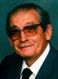
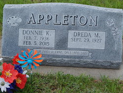
Don K. Appleton
| Birth | : | 7 Feb 1936 Green, Clay County, Kansas, USA |
| Death | : | 5 Feb 2015 Clay Center, Clay County, Kansas, USA |
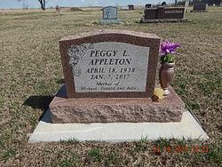
| Burial | : | Green Cemetery, Green, Clay County, USA |
| Coordinate | : | 39.4235992, -96.9882965 |
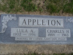
| Description | : | Don K. Appleton, age 78 of Green, Kansas passed away Thursday, February 5, 2015 at the Clay County Medical Center in Clay Center. He was born on February 7, 1936 in Green, Kansas, the son of Charles H. and Lula A. (Whitaker) Appleton. On October 12, 1967, he was married to Dreda Lister Sterrett in Green at his mother’s house. She survives at the Leonardville Nursing Home. Don was a carpenter and a draftsman. He worked for Mobil-Traveler in Junction City for 12 years and Wardcraft Homes in Clay Center for 12 years. Early in his working career he was an accountant. He... Read More |
frequently asked questions (FAQ):
-
Where is Don K. Appleton's memorial?
Don K. Appleton's memorial is located at: Green Cemetery, Green, Clay County, USA.
-
When did Don K. Appleton death?
Don K. Appleton death on 5 Feb 2015 in Clay Center, Clay County, Kansas, USA
-
Where are the coordinates of the Don K. Appleton's memorial?
Latitude: 39.4235992
Longitude: -96.9882965
Family Members:
Parent

Spouse
Siblings

Flowers:


Nearby Cemetories:
1. Green Cemetery
Green, Clay County, USA
Coordinate: 39.4235992, -96.9882965
2. Ebenezer Cemetery
Green, Clay County, USA
Coordinate: 39.3866997, -96.9974976
3. Pleasant Hill Cemetery
Leonardville, Riley County, USA
Coordinate: 39.4371210, -96.9426730
4. Lasita Cemetery
Leonardville, Riley County, USA
Coordinate: 39.4092900, -96.9422900
5. Fancy Creek Cemetery
Green, Clay County, USA
Coordinate: 39.4668999, -96.9969025
6. Brethren in Christ Cemetery
Clay County, USA
Coordinate: 39.4810982, -97.0344009
7. Hayes Cemetery
Clay County, USA
Coordinate: 39.4516983, -97.0811005
8. Clay County Poor Farm Cemetery
Clay Center, Clay County, USA
Coordinate: 39.3772700, -97.0727000
9. May Day Cemetery
Center Township, Riley County, USA
Coordinate: 39.4958000, -96.9302979
10. Goshen Central Cemetery
Clay Center, Clay County, USA
Coordinate: 39.5099983, -97.0160980
11. Joseph Sender Family Cemetery
Clay County, USA
Coordinate: 39.5090600, -97.0348800
12. Appleton Cemetery
Clay County, USA
Coordinate: 39.5250015, -96.9972000
13. Broughton Cemetery
Clay Center, Clay County, USA
Coordinate: 39.3306007, -97.0535965
14. Saint Peter and Saint Pauls Catholic Cemetery
Clay Center, Clay County, USA
Coordinate: 39.4005450, -97.1236680
15. Idylwilde Cemetery
Clay Center, Clay County, USA
Coordinate: 39.5097900, -97.0713000
16. Crooked Creek Cemetery
Randolph, Riley County, USA
Coordinate: 39.4369011, -96.8480988
17. Leonardville Cemetery
Leonardville, Riley County, USA
Coordinate: 39.3792000, -96.8589020
18. Greenwood Cemetery
Clay Center, Clay County, USA
Coordinate: 39.4011002, -97.1275024
19. Swedish Pleasant Hill Cemetery
Clay Center, Clay County, USA
Coordinate: 39.4735985, -97.1268997
20. Saint Johns Lutheran Cemetery
Winkler, Riley County, USA
Coordinate: 39.4813995, -96.8494034
21. Bala Cemetery
Bala, Riley County, USA
Coordinate: 39.3053017, -96.9341965
22. Leonardville United Methodist Cemetery
Leonardville, Riley County, USA
Coordinate: 39.3568700, -96.8493600
23. Walsburg Lutheran Cemetery
Leonardville, Riley County, USA
Coordinate: 39.3931100, -96.8133200
24. Swedish Evangelical Lutheran Cemetery
Clay County, USA
Coordinate: 39.4911700, -97.1455100