
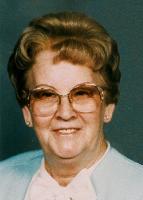
Mrs Dreda M. Lister Appleton
| Birth | : | 29 Sep 1927 Miltonvale, Cloud County, Kansas, USA |
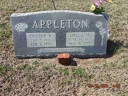
| Death | : | 16 May 2017 Leonardville, Riley County, Kansas, USA |
| Burial | : | Green Cemetery, Green, Clay County, USA |
| Coordinate | : | 39.4235992, -96.9882965 |
| Description | : | Dreda M. Appleton, age 89 formerly of Green, passed away Tuesday, May 16, 2017 at the Leonardville Nursing Home. She was born on September 29, 1927 in Miltonvale, the daughter of Frank H. and Lois Alice (Ray) Lister. She grew up and went to school in the Miltonvale area. She married Don Sterrett and had four children. They later divorced. On October 12, 1967, she was married to Don Appleton in Green. He preceded her in death in 2015. Dreda worked many jobs at places, such as the Green Grocery Store, Green Restaurant and Clay County Hospital. She... Read More |
frequently asked questions (FAQ):
-
Where is Mrs Dreda M. Lister Appleton's memorial?
Mrs Dreda M. Lister Appleton's memorial is located at: Green Cemetery, Green, Clay County, USA.
-
When did Mrs Dreda M. Lister Appleton death?
Mrs Dreda M. Lister Appleton death on 16 May 2017 in Leonardville, Riley County, Kansas, USA
-
Where are the coordinates of the Mrs Dreda M. Lister Appleton's memorial?
Latitude: 39.4235992
Longitude: -96.9882965
Family Members:

Flowers:


Nearby Cemetories:
1. Green Cemetery
Green, Clay County, USA
Coordinate: 39.4235992, -96.9882965
2. Ebenezer Cemetery
Green, Clay County, USA
Coordinate: 39.3866997, -96.9974976
3. Pleasant Hill Cemetery
Leonardville, Riley County, USA
Coordinate: 39.4371210, -96.9426730
4. Lasita Cemetery
Leonardville, Riley County, USA
Coordinate: 39.4092900, -96.9422900
5. Fancy Creek Cemetery
Green, Clay County, USA
Coordinate: 39.4668999, -96.9969025
6. Brethren in Christ Cemetery
Clay County, USA
Coordinate: 39.4810982, -97.0344009
7. Hayes Cemetery
Clay County, USA
Coordinate: 39.4516983, -97.0811005
8. Clay County Poor Farm Cemetery
Clay Center, Clay County, USA
Coordinate: 39.3772700, -97.0727000
9. May Day Cemetery
Center Township, Riley County, USA
Coordinate: 39.4958000, -96.9302979
10. Goshen Central Cemetery
Clay Center, Clay County, USA
Coordinate: 39.5099983, -97.0160980
11. Joseph Sender Family Cemetery
Clay County, USA
Coordinate: 39.5090600, -97.0348800
12. Appleton Cemetery
Clay County, USA
Coordinate: 39.5250015, -96.9972000
13. Broughton Cemetery
Clay Center, Clay County, USA
Coordinate: 39.3306007, -97.0535965
14. Saint Peter and Saint Pauls Catholic Cemetery
Clay Center, Clay County, USA
Coordinate: 39.4005450, -97.1236680
15. Idylwilde Cemetery
Clay Center, Clay County, USA
Coordinate: 39.5097900, -97.0713000
16. Crooked Creek Cemetery
Randolph, Riley County, USA
Coordinate: 39.4369011, -96.8480988
17. Leonardville Cemetery
Leonardville, Riley County, USA
Coordinate: 39.3792000, -96.8589020
18. Greenwood Cemetery
Clay Center, Clay County, USA
Coordinate: 39.4011002, -97.1275024
19. Swedish Pleasant Hill Cemetery
Clay Center, Clay County, USA
Coordinate: 39.4735985, -97.1268997
20. Saint Johns Lutheran Cemetery
Winkler, Riley County, USA
Coordinate: 39.4813995, -96.8494034
21. Bala Cemetery
Bala, Riley County, USA
Coordinate: 39.3053017, -96.9341965
22. Leonardville United Methodist Cemetery
Leonardville, Riley County, USA
Coordinate: 39.3568700, -96.8493600
23. Walsburg Lutheran Cemetery
Leonardville, Riley County, USA
Coordinate: 39.3931100, -96.8133200
24. Swedish Evangelical Lutheran Cemetery
Clay County, USA
Coordinate: 39.4911700, -97.1455100