
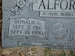
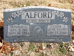
Donald G. Alford
| Birth | : | 2 Sep 1916 Lawrence, Douglas County, Kansas, USA |
| Death | : | 13 Sep 1990 Lawrence, Douglas County, Kansas, USA |
| Burial | : | Oak Hill Cemetery, Lawrence, Douglas County, USA |
| Coordinate | : | 38.9589005, -95.2118988 |
| Plot | : | Sec. 17 |
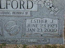
| Description | : | Services for Donald G. Alford, 74, Lawrence, are pending at Warren-McElwain Mortuary. Mr. Alford died today at Lawrence Memorial Hospital after a long illness. He was a retired farmer and dairyman. He was born Sept. 2, 1916, in Lawrence and had lived his entire life in the area. Mr. Alford was a member of the National Ayrshire Assn., the Dairy Shrine, the Mid-America Dairymen and the Douglas County Farmer's Co-op. He was married Sept. 2, 1944, to Esther L. Jones. She survives of the home. Other survivors include four daughters, Patricia Price, Perry, Donna Buchanan, Perry, Linda Jurgensen, Wichita, and Sherri Bray, Lawrence; two brothers,... Read More |
frequently asked questions (FAQ):
-
Where is Donald G. Alford's memorial?
Donald G. Alford's memorial is located at: Oak Hill Cemetery, Lawrence, Douglas County, USA.
-
When did Donald G. Alford death?
Donald G. Alford death on 13 Sep 1990 in Lawrence, Douglas County, Kansas, USA
-
Where are the coordinates of the Donald G. Alford's memorial?
Latitude: 38.9589005
Longitude: -95.2118988
Family Members:
Spouse
Children
Flowers:


Nearby Cemetories:
1. Oak Hill Cemetery
Lawrence, Douglas County, USA
Coordinate: 38.9589005, -95.2118988
2. Mount Calvary Catholic Cemetery
Lawrence, Douglas County, USA
Coordinate: 38.9580002, -95.2139969
3. Memorial Park Cemetery
Lawrence, Douglas County, USA
Coordinate: 38.9552994, -95.2153015
4. Trinity Episcopal Church Columbarium
Lawrence, Douglas County, USA
Coordinate: 38.9653893, -95.2373886
5. Saint Johns Catholic Cemetery
Douglas County, USA
Coordinate: 38.9437900, -95.1919600
6. Dyche Hall Natural History Museum
Lawrence, Douglas County, USA
Coordinate: 38.9584800, -95.2434800
7. Franklin Cemetery
Douglas County, USA
Coordinate: 38.9437523, -95.1869431
8. Haskell Cemetery
Lawrence, Douglas County, USA
Coordinate: 38.9353790, -95.2284241
9. Pioneer Cemetery
Lawrence, Douglas County, USA
Coordinate: 38.9528008, -95.2611008
10. First Presbyterian Church Memorial Garden
Lawrence, Douglas County, USA
Coordinate: 38.9414900, -95.2641600
11. Maple Grove Cemetery
Lawrence, Douglas County, USA
Coordinate: 39.0018997, -95.2316971
12. County Poor Farm Cemetery
Douglas County, USA
Coordinate: 38.9119400, -95.2214600
13. Adams Cemetery
Douglas County, USA
Coordinate: 38.9955400, -95.2509100
14. Kennedy Cemetery
Douglas County, USA
Coordinate: 38.9112900, -95.2269200
15. Davis Cemetery
Lawrence, Douglas County, USA
Coordinate: 38.9722500, -95.2831100
16. Blue Mound Cemetery
Lawrence, Douglas County, USA
Coordinate: 38.9046600, -95.1865400
17. Marshall Cemetery
Douglas County, USA
Coordinate: 38.9040800, -95.2446700
18. Dutton Cemetery
Douglas County, USA
Coordinate: 38.8989800, -95.2790600
19. Luckan Family Cemetery
Fall Leaf, Leavenworth County, USA
Coordinate: 38.9808500, -95.1128000
20. Cemetery Beni Israel
Eudora, Douglas County, USA
Coordinate: 38.9280128, -95.1122208
21. Southwest City Cemetery
Eudora, Douglas County, USA
Coordinate: 38.9334800, -95.1070300
22. Lyon Family Cemetery
Lawrence, Douglas County, USA
Coordinate: 38.9877440, -95.3166530
23. Corpus Christi Catholic Church Columbarium
Lawrence, Douglas County, USA
Coordinate: 38.9572250, -95.3238450
24. Richland Cemetery
Lawrence, Douglas County, USA
Coordinate: 38.8768997, -95.2630997