
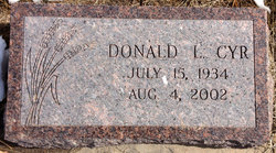
Donald L “Don” Cyr
| Birth | : | 15 Jul 1934 Ames, Cloud County, Kansas, USA |
| Death | : | 4 Aug 2002 Concordia, Cloud County, Kansas, USA |
| Burial | : | Mount Hope Cemetery, Clyde, Cloud County, USA |
| Coordinate | : | 39.5969009, -97.4116974 |
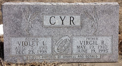
| Description | : | The Hays Daily News - Aug 6, 2002 Don L. Cyr AMES — Don L. Cyr, 68, died Sunday, Aug. 4, 2002, in Concordia. He was born July 15, 1934, in Ames to Virgil R. and Violet L. (Carver) Cyr. He graduated from Clyde High School and was a U.S. Army Air Corps veteran. He married Alberta Haist on Nov. 24, 1973, in Clyde. He farmed in the Ames area, where he was a resident most of his life. He was a member of Clyde Christian Church and American Legion, Clifton. Survivors include his wife, Concordia; a daughter, Alyson Redfern, San Antonio; two stepdaughters,... Read More |
frequently asked questions (FAQ):
-
Where is Donald L “Don” Cyr's memorial?
Donald L “Don” Cyr's memorial is located at: Mount Hope Cemetery, Clyde, Cloud County, USA.
-
When did Donald L “Don” Cyr death?
Donald L “Don” Cyr death on 4 Aug 2002 in Concordia, Cloud County, Kansas, USA
-
Where are the coordinates of the Donald L “Don” Cyr's memorial?
Latitude: 39.5969009
Longitude: -97.4116974
Family Members:
Parent

Spouse

Siblings
Flowers:


Nearby Cemetories:
1. Mount Calvary Cemetery
Clyde, Cloud County, USA
Coordinate: 39.5917015, -97.4143982
2. Cedar Grove Cemetery
Clyde, Cloud County, USA
Coordinate: 39.5494003, -97.4056015
3. Pleasant View Cemetery
Ames, Cloud County, USA
Coordinate: 39.5346985, -97.4431000
4. Walnut Grove Cemetery
Cloud County, USA
Coordinate: 39.5699997, -97.4993973
5. Agenda Cemetery
Agenda, Republic County, USA
Coordinate: 39.6761017, -97.4336014
6. Saint Joseph Cemetery
Saint Joseph, Cloud County, USA
Coordinate: 39.5074941, -97.4022328
7. Beck Family Cemetery
Agenda, Republic County, USA
Coordinate: 39.6818000, -97.4863000
8. Green Mound Cemetery
Rice, Cloud County, USA
Coordinate: 39.5248450, -97.5081630
9. Hollis Cemetery
Cloud County, USA
Coordinate: 39.6383018, -97.5361023
10. Rice Cemetery
Rice, Cloud County, USA
Coordinate: 39.5614014, -97.5552979
11. Nelson Cemetery
Rice, Cloud County, USA
Coordinate: 39.5257988, -97.5410995
12. Riverdale Cemetery
Clay County, USA
Coordinate: 39.5106010, -97.2930984
13. Willoughby Cemetery
Agenda, Republic County, USA
Coordinate: 39.7402992, -97.4244003
14. Union Cemetery
Wayne, Republic County, USA
Coordinate: 39.6977997, -97.5457993
15. Saint Peters Cemetery
Aurora, Cloud County, USA
Coordinate: 39.4763985, -97.5180969
16. Princeville Cemetery
Aurora, Cloud County, USA
Coordinate: 39.4672012, -97.5010986
17. Iwacura Cemetery
Morganville, Clay County, USA
Coordinate: 39.4550000, -97.3510000
18. Gotland Cemetery
Sibley Township, Cloud County, USA
Coordinate: 39.6091995, -97.6125031
19. French Presbyterian Church Cemetery
Cloud County, USA
Coordinate: 39.4395200, -97.4148290
20. Sherman Cemetery
Morganville, Clay County, USA
Coordinate: 39.5316300, -97.2243700
21. Zion Cemetery
Agenda, Republic County, USA
Coordinate: 39.6749992, -97.5939026
22. Rose Hill Cemetery
Wayne, Republic County, USA
Coordinate: 39.7111015, -97.5661011
23. Minersville Cemetery
Talmo, Republic County, USA
Coordinate: 39.6568330, -97.6229250
24. Bloom Cemetery
Morganville, Clay County, USA
Coordinate: 39.4519005, -97.2778015