

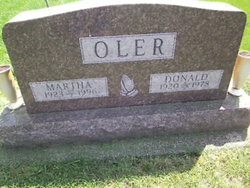
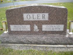
Donald L. Oler
| Birth | : | 23 Sep 1920 Greens Fork, Wayne County, Indiana, USA |
| Death | : | Feb 1978 Wayne County, Indiana, USA |
| Burial | : | Economy Cemetery, Economy, Wayne County, USA |
| Coordinate | : | 39.9832993, -85.0942001 |
| Plot | : | Lot 196 |
| Description | : | MOTHER: Ethel Josephine Howard FATHER: Lonel Oler WIFE: Martha L. Lester, 1923 - 1996 SOURCES: 1. Donald L Oler, "Indiana, Marriages, 1811-1959" Name: Donald L Oler Event Type: Marriage Registration Place: Wayne, Indiana, United States Marriage License Date: 23 Aug 1941 Residence Place: Greensfork Twp, , Indiana Gender: Male Age (Estimated): Number of Previous Marriages: Race (Original): White Birth Date: 23 Sep 1920 Birthplace: Greensfork Twp, , Indiana Father's Name: Lonel Oler Mother's Name: Ethel Howard Spouse's Name: Martha L Lester Spouse's Gender: Female Page: 99 GS... Read More |
frequently asked questions (FAQ):
-
Where is Donald L. Oler's memorial?
Donald L. Oler's memorial is located at: Economy Cemetery, Economy, Wayne County, USA.
-
When did Donald L. Oler death?
Donald L. Oler death on Feb 1978 in Wayne County, Indiana, USA
-
Where are the coordinates of the Donald L. Oler's memorial?
Latitude: 39.9832993
Longitude: -85.0942001
Family Members:
Parent

Spouse
Siblings
Children
Flowers:


Nearby Cemetories:
1. Economy Cemetery
Economy, Wayne County, USA
Coordinate: 39.9832993, -85.0942001
2. Jordon Cemetery
Economy, Wayne County, USA
Coordinate: 40.0041490, -85.1209120
3. Bethel United Brethren Cemetery
Economy, Wayne County, USA
Coordinate: 39.9469980, -85.1076720
4. West River Friends Cemetery
Dalton, Wayne County, USA
Coordinate: 39.9826780, -85.1468510
5. Williamson Road Amish Cemetery
Economy, Wayne County, USA
Coordinate: 39.9497920, -85.0629710
6. Little Creek Cemetery
Losantville, Randolph County, USA
Coordinate: 40.0121994, -85.1433029
7. Smith Cemetery
Modoc, Randolph County, USA
Coordinate: 40.0341860, -85.1092390
8. Union Chapel Methodist Cemetery
Carlos, Randolph County, USA
Coordinate: 40.0261002, -85.0519028
9. Olive Branch Cemetery
Hagerstown, Wayne County, USA
Coordinate: 39.9379000, -85.1355560
10. Cook Cemetery
Williamsburg, Wayne County, USA
Coordinate: 39.9853930, -85.0158670
11. Mount Pleasant Cemetery
Wayne County, USA
Coordinate: 39.9903060, -85.0105980
12. Sugar Grove Cemetery
Wayne County, USA
Coordinate: 39.9211006, -85.0721283
13. Salem Cemetery
Modoc, Randolph County, USA
Coordinate: 40.0485850, -85.1097210
14. Nettle Creek Friends Quaker Cemetery
Dalton, Wayne County, USA
Coordinate: 39.9743190, -85.1871830
15. Nettle Creek Baptist Cemetery
Losantville, Randolph County, USA
Coordinate: 40.0077960, -85.1826080
16. Williamsburg Cemetery
Williamsburg, Wayne County, USA
Coordinate: 39.9547005, -85.0036011
17. Tharp Burial Ground
Losantville, Randolph County, USA
Coordinate: 40.0262010, -85.1799630
18. Lewis Family Cemetery
Williamsburg, Wayne County, USA
Coordinate: 39.9403910, -85.0059530
19. Bald Ridge Cemetery
Hagerstown, Wayne County, USA
Coordinate: 39.9009500, -85.1130800
20. Salem Baptist Church Cemetery
Hagerstown, Wayne County, USA
Coordinate: 39.8988991, -85.0971985
21. Ulrich Cemetery
Hagerstown, Wayne County, USA
Coordinate: 39.9433340, -85.1958900
22. Huntsville Cemetery
Modoc, Randolph County, USA
Coordinate: 40.0699043, -85.0752182
23. Bales Cemetery
Mooreland, Henry County, USA
Coordinate: 39.9610370, -85.2055620
24. West Lawn Cemetery
Hagerstown, Wayne County, USA
Coordinate: 39.9138985, -85.1667023