
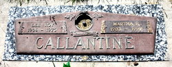
| Birth | : | 2 Dec 1928 Menard, Gallatin County, Montana, USA |
| Death | : | 27 Sep 2001 Mountain Home, Baxter County, Arkansas, USA |
| Burial | : | Pilarcitos Cemetery, Half Moon Bay, San Mateo County, USA |
| Coordinate | : | 37.4682140, -122.4292450 |
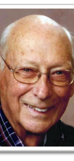
| Description | : | Donald Leroy Callantine, 72, of Norfork, formerly of Rector, died Thursday, Sept. 27, 2001, at Mountain Home. He was born Dec. 2, 1928, in Manard, Mont. He was a retired auto mechanic and Air Force veteran having served in World War II and Korea. He enjoyed fishing, hunting, oil painting and camping. He was a Protestant. He was preceded in death by his parents, Roy and Emma Bennett Callantine, and a brother. Survivors include his wife, Madge Crawford Callantine; four sons and daughters-in-law, Marty and Cathy Callantine of Paragould, Bob and Debbie Callantine of Flippin, Daniel and Jennifer Callantine of Clarkridge and Bryan and... Read More |
frequently asked questions (FAQ):
-
Where is Donald Leroy Callantine's memorial?
Donald Leroy Callantine's memorial is located at: Pilarcitos Cemetery, Half Moon Bay, San Mateo County, USA.
-
When did Donald Leroy Callantine death?
Donald Leroy Callantine death on 27 Sep 2001 in Mountain Home, Baxter County, Arkansas, USA
-
Where are the coordinates of the Donald Leroy Callantine's memorial?
Latitude: 37.4682140
Longitude: -122.4292450
Family Members:
Parent
Siblings
Flowers:


Nearby Cemetories:
1. Pilarcitos Cemetery
Half Moon Bay, San Mateo County, USA
Coordinate: 37.4682140, -122.4292450
2. Independent Order of Odd Fellows Cemetery
Half Moon Bay, San Mateo County, USA
Coordinate: 37.4688510, -122.4274620
3. Our Lady of the Pillar Cemetery
Half Moon Bay, San Mateo County, USA
Coordinate: 37.4611610, -122.4263460
4. Skylawn Memorial Park
San Mateo, San Mateo County, USA
Coordinate: 37.4967120, -122.3697780
5. Gan Hazikaron Cemetery
San Mateo, San Mateo County, USA
Coordinate: 37.4960740, -122.3683830
6. Purissima Cemetery
Half Moon Bay, San Mateo County, USA
Coordinate: 37.4038860, -122.4150020
7. San Mateo County Poor Farm Cemetery
San Mateo, San Mateo County, USA
Coordinate: 37.5153430, -122.3350060
8. Harrington Cemetery
Belmont, San Mateo County, USA
Coordinate: 37.5032997, -122.3238983
9. Bourn Family Cemetery
Woodside, San Mateo County, USA
Coordinate: 37.4676100, -122.3124400
10. Saint John's Cemetery
San Mateo, San Mateo County, USA
Coordinate: 37.5483017, -122.3358002
11. Episcopal Church of Transfiguration Memorial Garde
San Mateo, San Mateo County, USA
Coordinate: 37.5273480, -122.3058880
12. First Presbyterian Church Prayer Garden
Burlingame, San Mateo County, USA
Coordinate: 37.5857740, -122.3704280
13. Mathias Alfred Parkhurst Burial Site
Woodside, San Mateo County, USA
Coordinate: 37.4306710, -122.2770660
14. Saint Peters Episcopal Church Columbarium
Redwood City, San Mateo County, USA
Coordinate: 37.4855750, -122.2389540
15. Golden Gate National Cemetery
San Bruno, San Mateo County, USA
Coordinate: 37.6312447, -122.4348679
16. Gorilla Foundation Sanctuary
Woodside, San Mateo County, USA
Coordinate: 37.3750160, -122.2604360
17. Union Cemetery
Redwood City, San Mateo County, USA
Coordinate: 37.4732700, -122.2231360
18. Dennis Martin Cemetery
San Mateo County, USA
Coordinate: 37.4203440, -122.2181370
19. Christ Episcopal Church Churchyard Columbarium
Portola Valley, San Mateo County, USA
Coordinate: 37.3821670, -122.2304160
20. Saint Bedes Episcopal Church Cemetery
Menlo Park, San Mateo County, USA
Coordinate: 37.4218750, -122.2075210
21. Orange Memorial Park (Defunct)
South San Francisco, San Mateo County, USA
Coordinate: 37.6542015, -122.4257965
22. Oakwood Community Cemetery
Atherton, San Mateo County, USA
Coordinate: 37.4503120, -122.1956310
23. Holy Cross Catholic Cemetery
Menlo Park, San Mateo County, USA
Coordinate: 37.4350420, -122.1978540
24. Corpus Christi Monastery
Menlo Park, San Mateo County, USA
Coordinate: 37.4589200, -122.1801900