
| Birth | : | 7 Mar 1934 Emerson, Kent County, New Brunswick, Canada |
| Death | : | 29 Nov 2004 Moncton, Westmorland County, New Brunswick, Canada |
| Burial | : | Saint Paul’s Anglican Church Cemetery, Browns Yard, Kent County, Canada |
| Coordinate | : | 46.5211100, -65.0864800 |
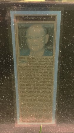
| Description | : | Donald R. Beers, who was more familiarly known as Donnie, owned and operated D.R. Beers and Son Construction as well as Terra Blends, serving the city of Moncton and outlying areas for over 30 years. Donnie was also a former stock car driver who raced in New Brunswick and other parts of the Maritimes. Donnie was well known for his fierce competitiveness and winning attitude. Donnie and the #3 car were crowd favorites who pleased and exited race fans for many years. Donnie still enjoyed the sport of stock car racing and made numerous trips to the NASCAR race circuit.... Read More |
frequently asked questions (FAQ):
-
Where is Donald R. Beers's memorial?
Donald R. Beers's memorial is located at: Saint Paul’s Anglican Church Cemetery, Browns Yard, Kent County, Canada.
-
When did Donald R. Beers death?
Donald R. Beers death on 29 Nov 2004 in Moncton, Westmorland County, New Brunswick, Canada
-
Where are the coordinates of the Donald R. Beers's memorial?
Latitude: 46.5211100
Longitude: -65.0864800
Family Members:
Parent

Siblings
Flowers:


Nearby Cemetories:
1. Saint Paul’s Anglican Church Cemetery
Browns Yard, Kent County, Canada
Coordinate: 46.5211100, -65.0864800
2. St. Mark's Presbyterian Cemetery
Bass River, Kent County, Canada
Coordinate: 46.5424130, -65.0894630
3. Fords Mills United Church Cemetery
Fords Mills, Kent County, Canada
Coordinate: 46.4873010, -65.0904990
4. Saint Bartholomew Roman Catholic Cemetery
Bass River, Kent County, Canada
Coordinate: 46.5539410, -65.1073140
5. St. Bartholomew's Roman Catholic Cemetery
Molus River, Kent County, Canada
Coordinate: 46.5739550, -65.0830720
6. St. Stephens United Church Cemetery
Molus River, Kent County, Canada
Coordinate: 46.5763290, -65.0817130
7. St. James Presbyterian Church Cemetery
Beersville, Kent County, Canada
Coordinate: 46.4601550, -65.0827550
8. Whispering Pines Cemetery
Harcourt, Kent County, Canada
Coordinate: 46.4849750, -65.1864790
9. Gospel Hall Emerson Road Cemetery
Harcourt, Kent County, Canada
Coordinate: 46.4710190, -65.1841700
10. United-Methodist Church Cemetery
Beersville, Kent County, Canada
Coordinate: 46.4319880, -65.0778700
11. Saint John's United Church Cemetery
West Branch, Kent County, Canada
Coordinate: 46.5339660, -64.9571180
12. Saint Anne's Roman Catholic Cemetery
Big Cove, Kent County, Canada
Coordinate: 46.5854736, -64.9864107
13. West Branch Presbyterian Cemetery
West Branch, Kent County, Canada
Coordinate: 46.5410340, -64.9480820
14. Saint-Norbert Parish Cemetery
Saint-Norbert, Kent County, Canada
Coordinate: 46.4662200, -64.9683100
15. Kingdom Hall of Jehovah's Witnesses Cemetery
West Branch, Kent County, Canada
Coordinate: 46.5497546, -64.9345299
16. Saint Matthews Anglican Church Cemetery
Harcourt, Kent County, Canada
Coordinate: 46.4706480, -65.2347930
17. Adamsville Baptist Cemetery
Adamsville, Kent County, Canada
Coordinate: 46.4102040, -65.1567110
18. Wesley Memorial United Church Cemetery
Harcourt, Kent County, Canada
Coordinate: 46.4720060, -65.2485500
19. Saint Andrews Presbyterian Cemetery
Harcourt, Kent County, Canada
Coordinate: 46.4726940, -65.2500790
20. Grangeville United Baptist Church Cemetery
Harcourt, Kent County, Canada
Coordinate: 46.4170870, -65.2126310
21. Saint Matthews United Church Cemetery
Clairville, Kent County, Canada
Coordinate: 46.3849490, -65.0982270
22. Chapel Point Cemetery
Richibucto, Kent County, Canada
Coordinate: 46.5966300, -64.9202300
23. Saint Timothy’s Roman Catholic Cemetery
Adamsville, Kent County, Canada
Coordinate: 46.4001080, -65.1870430
24. Methodist Point Cemetery
Rexton, Kent County, Canada
Coordinate: 46.6042300, -64.9165060