
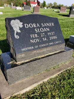
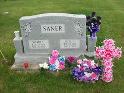
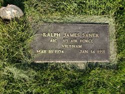
Dora Saner Sloan
| Birth | : | 27 Feb 1937 Albia, Monroe County, Iowa, USA |
| Death | : | 14 Nov 2006 Mount Pleasant, Henry County, Iowa, USA |
| Burial | : | Baptist Burial Ground, Center Sandwich, Carroll County, USA |
| Coordinate | : | 43.8079900, -71.4392600 |
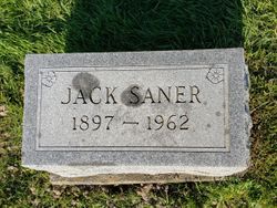
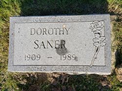
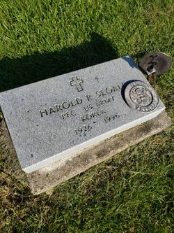
| Description | : | Dora Saner Sloan, 69, of New London, formerly of the Eldon area, died at Henry County Health Center. Born in Albia, she was the daughter of Jack and Dorothy Herbert Saner. On July 22, 1956, she married Harold Sloan in Ottumwa. He died July 11, 1996. Mrs. Sloan moved to New London in 1966 and worked 33 years at the Iowa Army Ammunition Plant in Middletown. She retired in 2000. She was raised in Albia and was a 1956 graduate of Eldon High School. Survivors include one son, Stanley Sloan of Wayland; one daughter, Cheryl Sloan of Burlington; five grandchildren;... Read More |
frequently asked questions (FAQ):
-
Where is Dora Saner Sloan's memorial?
Dora Saner Sloan's memorial is located at: Baptist Burial Ground, Center Sandwich, Carroll County, USA.
-
When did Dora Saner Sloan death?
Dora Saner Sloan death on 14 Nov 2006 in Mount Pleasant, Henry County, Iowa, USA
-
Where are the coordinates of the Dora Saner Sloan's memorial?
Latitude: 43.8079900
Longitude: -71.4392600
Family Members:
Parent
Spouse
Siblings

Flowers:


Nearby Cemetories:
1. Baptist Burial Ground
Center Sandwich, Carroll County, USA
Coordinate: 43.8079900, -71.4392600
2. Grove Cemetery
Sandwich, Carroll County, USA
Coordinate: 43.8101100, -71.4445200
3. Elm Hill Cemetery
Sandwich, Carroll County, USA
Coordinate: 43.8158330, -71.4338890
4. Elm Hill Cemetery
Center Sandwich, Carroll County, USA
Coordinate: 43.8158000, -71.4336000
5. Cemetery of the Religious Society of Friends
Sandwich, Carroll County, USA
Coordinate: 43.7994400, -71.4266700
6. Beede Cemetery
Sandwich, Carroll County, USA
Coordinate: 43.8013890, -71.4166670
7. Mason Cemetery
Center Sandwich, Carroll County, USA
Coordinate: 43.7858000, -71.4258000
8. Chicks Corner Cemetery
Sandwich, Carroll County, USA
Coordinate: 43.8041000, -71.4728900
9. Littles Pond Cemetery
Sandwich, Carroll County, USA
Coordinate: 43.7915600, -71.4034200
10. Moulton-Beede Cemetery
Sandwich, Carroll County, USA
Coordinate: 43.7774000, -71.4276000
11. Smith-Morse Cemetery
Sandwich, Carroll County, USA
Coordinate: 43.7768000, -71.4301000
12. Israel Gilman Cemetery
Sandwich Landing, Carroll County, USA
Coordinate: 43.8268727, -71.4757671
13. Haines Cemetery
Union, Carroll County, USA
Coordinate: 43.7734000, -71.4331000
14. Quinby Cemetery
North Sandwich, Carroll County, USA
Coordinate: 43.8433000, -71.4148000
15. Mears-Nelson Cemetery
Sandwich, Carroll County, USA
Coordinate: 43.7932790, -71.3820560
16. Nathanial Fry Family Plot
Sandwich, Carroll County, USA
Coordinate: 43.7875872, -71.3844592
17. North Sandwich Cemetery
North Sandwich, Carroll County, USA
Coordinate: 43.8410750, -71.3953610
18. Thompson Cemetery
Sandwich, Carroll County, USA
Coordinate: 43.8014000, -71.5025000
19. Mason Cemetery
North Sandwich, Carroll County, USA
Coordinate: 43.8542000, -71.4426000
20. Morse Cemetery
Center Sandwich, Carroll County, USA
Coordinate: 43.8534300, -71.4241600
21. Richard Fry Cemetery
Sandwich, Carroll County, USA
Coordinate: 43.7822817, -71.3830099
22. Mason Cemetery
Moultonborough, Carroll County, USA
Coordinate: 43.7574500, -71.4184000
23. Freese Cemetery
Moultonborough, Carroll County, USA
Coordinate: 43.7616670, -71.4008330
24. Holland Hill Cemetery
Moultonborough, Carroll County, USA
Coordinate: 43.7620300, -71.3995400