
| Birth | : | 28 Aug 1911 Navarre, Dickinson County, Kansas, USA |
| Death | : | 2 Jul 1930 Dickinson County, Kansas, USA |
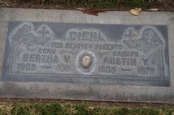
| Burial | : | Sherwood Cemetery, Sherwood, Defiance County, USA |
| Coordinate | : | 41.2900009, -84.5507965 |
| Description | : | Dorothy Adaline Gish was the daughter of John Moyer and Mary Rebecca Caskey Gish. She married Austin Young Diehl 20 Jun 1929. She died giving birth to twins and had toxiema of Pregnancy. Charlene and Charlotte are the names of the twins. They were raised by their grandparents John and Mary Gish. |
frequently asked questions (FAQ):
-
Where is Dorothy Adaline Gish Diehl's memorial?
Dorothy Adaline Gish Diehl's memorial is located at: Sherwood Cemetery, Sherwood, Defiance County, USA.
-
When did Dorothy Adaline Gish Diehl death?
Dorothy Adaline Gish Diehl death on 2 Jul 1930 in Dickinson County, Kansas, USA
-
Where are the coordinates of the Dorothy Adaline Gish Diehl's memorial?
Latitude: 41.2900009
Longitude: -84.5507965
Family Members:
Parent

Spouse
Siblings
Children
Flowers:


Nearby Cemetories:
1. Sherwood Cemetery
Sherwood, Defiance County, USA
Coordinate: 41.2900009, -84.5507965
2. Blair Cemetery
Sherwood, Defiance County, USA
Coordinate: 41.2677994, -84.5436020
3. Saint Stephens New Catholic Cemetery
The Bend, Defiance County, USA
Coordinate: 41.2820100, -84.5150800
4. Glore Cemetery
Sherwood, Defiance County, USA
Coordinate: 41.2639008, -84.5342026
5. Liggett Scouts Burial Ground
The Bend, Defiance County, USA
Coordinate: 41.2761100, -84.5154500
6. Shirley Family Cemetery
The Bend, Defiance County, USA
Coordinate: 41.2821360, -84.5071690
7. Blue Cemetery
The Bend, Defiance County, USA
Coordinate: 41.2871500, -84.5033200
8. Saint Johns Lutheran Cemetery
Sherwood, Defiance County, USA
Coordinate: 41.3092003, -84.5931015
9. Saint Stephens Old Cemetery
Defiance County, USA
Coordinate: 41.2747002, -84.4955978
10. Moats Cemetery
Defiance County, USA
Coordinate: 41.3330420, -84.5194530
11. Colby Cemetery
Defiance County, USA
Coordinate: 41.2532997, -84.5952988
12. Eaton Cemetery
Paulding County, USA
Coordinate: 41.2402992, -84.5783005
13. Funk Cemetery
Defiance County, USA
Coordinate: 41.3396988, -84.5164032
14. Auglaize Village Cemetery
Defiance, Defiance County, USA
Coordinate: 41.3399760, -84.5165610
15. Hill Cemetery
Sherwood, Defiance County, USA
Coordinate: 41.2824550, -84.4687870
16. Immaculate Conception Cemetery
Crane Township, Paulding County, USA
Coordinate: 41.2325500, -84.5905100
17. Rochester Cemetery
Cecil, Paulding County, USA
Coordinate: 41.2313995, -84.5914001
18. Tuttle Cemetery
Defiance, Defiance County, USA
Coordinate: 41.2756004, -84.4475021
19. Lintz Cemetery
Ney, Defiance County, USA
Coordinate: 41.3760986, -84.5402985
20. Renollet Cemetery
Paulding County, USA
Coordinate: 41.2122002, -84.5000000
21. Pioneer Cemetery
Defiance County, USA
Coordinate: 41.2641200, -84.4404200
22. Gordon Cemetery
Paulding County, USA
Coordinate: 41.2318993, -84.6433029
23. Blair-Adams Sun Valley Cemetery
Cecil, Paulding County, USA
Coordinate: 41.2177180, -84.4772200
24. Marysdale Immaculate Conception Catholic Cemetery
Ney, Defiance County, USA
Coordinate: 41.3499985, -84.4580994