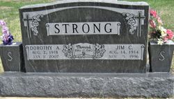
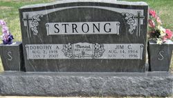
Dorothy Boyd Strong
| Birth | : | 2 Aug 1918 Moran, Allen County, Kansas, USA |
| Death | : | 11 Jan 2007 Moran, Allen County, Kansas, USA |
| Burial | : | St. Mary's Churchyard, Knowsley, Metropolitan Borough of Knowsley, England |
| Coordinate | : | 53.4561960, -2.8528580 |
| Plot | : | Sec South, Blk 1, Row 2, Lot 87, Sp 3 |
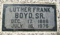
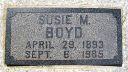
| Description | : | *********************************** Iola Register ~ Iola, KS ~ January 12, 2007 Dorothy Strong, 88, of Moran, Kansas, died Thursday, Jan. 11, 2007, at Moran Manor. She was born Aug. 2, 1918, in Moran, Kansas, the daughter of Luther Frank and Susie (Shouse) Boyd Sr. Her family family later moved to Camden Point, MO, and then returned to Moran. She graduated from Moran High School in 1936. She was then graduated from lola Junior College in 1938. She was married to James Curtis Strong May 12, 1940, in Fort Scott, KS. He died Nov. 5, 1996. She taught school in a one-room... Read More |
frequently asked questions (FAQ):
-
Where is Dorothy Boyd Strong's memorial?
Dorothy Boyd Strong's memorial is located at: St. Mary's Churchyard, Knowsley, Metropolitan Borough of Knowsley, England.
-
When did Dorothy Boyd Strong death?
Dorothy Boyd Strong death on 11 Jan 2007 in Moran, Allen County, Kansas, USA
-
Where are the coordinates of the Dorothy Boyd Strong's memorial?
Latitude: 53.4561960
Longitude: -2.8528580
Family Members:
Parent
Spouse
Siblings
Flowers:
Nearby Cemetories:
1. St. Mary's Churchyard
Knowsley, Metropolitan Borough of Knowsley, England
Coordinate: 53.4561960, -2.8528580
2. St Swithins Churchyard
Liverpool, Metropolitan Borough of Liverpool, England
Coordinate: 53.4585631, -2.9012280
3. GreenAcres Cemetery
Rainford, Metropolitan Borough of St Helens, England
Coordinate: 53.4713530, -2.8064280
4. Yew Tree Roman Catholic Cemetery
West Derby, Metropolitan Borough of Liverpool, England
Coordinate: 53.4285700, -2.8790700
5. West Derby Jewish Cemetery
Liverpool, Metropolitan Borough of Liverpool, England
Coordinate: 53.4504986, -2.9137393
6. St. Chad Churchyard
Kirkby, Metropolitan Borough of Knowsley, England
Coordinate: 53.4842890, -2.8930700
7. West Derby Cemetery
West Derby, Metropolitan Borough of Liverpool, England
Coordinate: 53.4513790, -2.9154630
8. St. Mary the Virgin Churchyard
Prescot, Metropolitan Borough of Knowsley, England
Coordinate: 53.4284600, -2.8067000
9. Prescot Cemetery
Prescot, Metropolitan Borough of Knowsley, England
Coordinate: 53.4266620, -2.8081590
10. St Michael Churchyard Extension
Huyton with Roby, Metropolitan Borough of Knowsley, England
Coordinate: 53.4143310, -2.8418050
11. St. Michael Churchyard
Huyton with Roby, Metropolitan Borough of Knowsley, England
Coordinate: 53.4139560, -2.8396720
12. St. Bartholomew's Churchyard
Huyton with Roby, Metropolitan Borough of Knowsley, England
Coordinate: 53.4120023, -2.8556125
13. Christ Church Churchyard
Eccleston, Metropolitan Borough of St Helens, England
Coordinate: 53.4542560, -2.7778900
14. St. John the Evangelist Churchyard
Knotty Ash, Metropolitan Borough of Liverpool, England
Coordinate: 53.4160757, -2.8913708
15. St. Agnes Roman Catholic
Huyton with Roby, Metropolitan Borough of Knowsley, England
Coordinate: 53.4090600, -2.8320100
16. Long Lane Jewish Cemetery
Liverpool, Metropolitan Borough of Liverpool, England
Coordinate: 53.4550140, -2.9420480
17. Broadgreen Jewish Cemetery
Liverpool, Metropolitan Borough of Liverpool, England
Coordinate: 53.4101320, -2.8977320
18. Everton Cemetery
Everton, Metropolitan Borough of Liverpool, England
Coordinate: 53.4555430, -2.9442480
19. Green Lane Jewish Cemetery
Liverpool, Metropolitan Borough of Liverpool, England
Coordinate: 53.4234720, -2.9280170
20. St. Helen's Cemetery and Crematorium
St Helens, Metropolitan Borough of St Helens, England
Coordinate: 53.4678993, -2.7607000
21. Melling Churchyard
Melling, Metropolitan Borough of Sefton, England
Coordinate: 53.4953370, -2.9228780
22. St Thomas and the Holy Rood Churchyard
Melling, Metropolitan Borough of Sefton, England
Coordinate: 53.4954510, -2.9227850
23. Saint Oswald King & Martyr Catholic Churchyard
Old Swan, Metropolitan Borough of Liverpool, England
Coordinate: 53.4121650, -2.9146190
24. St. Nicholas' Churchyard
Whiston, Metropolitan Borough of Knowsley, England
Coordinate: 53.4069736, -2.8028920


