
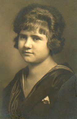

Dorothy Helen Osborne Keller
| Birth | : | 16 Nov 1905 Peru, Miami County, Indiana, USA |
| Death | : | 17 Jul 1976 Rochester, Fulton County, Indiana, USA |
| Burial | : | Eltham Cemetery, Eltham, South Taranaki District, New Zealand |
| Coordinate | : | -39.4197140, 174.3251260 |
| Plot | : | Section 15, Row 4 |
| Description | : | Published in The Rochester Sentinel Monday, July 19, 1976 Dorothy H. Keller Dorothy Helen KELLER, 70, 1530 Sunset drive, died Saturday at 6 p.m. at her residence. She was born Nov. 16, 1905 in Peru to Roy and Lottie STUBBS OSBORNE. Her marriage was July 10, 1954 to Herbert B. KELLER. He died June 26, 1969. She had resided in this area since 1968, coming from Granger. She was a retired employee of the Uniroyal plant in Mishawaka having worked there as an accountant. She was a member of the First United Presbyterian church of Rochester and a 1923 graduate of Rochester high school.... Read More |
frequently asked questions (FAQ):
-
Where is Dorothy Helen Osborne Keller's memorial?
Dorothy Helen Osborne Keller's memorial is located at: Eltham Cemetery, Eltham, South Taranaki District, New Zealand.
-
When did Dorothy Helen Osborne Keller death?
Dorothy Helen Osborne Keller death on 17 Jul 1976 in Rochester, Fulton County, Indiana, USA
-
Where are the coordinates of the Dorothy Helen Osborne Keller's memorial?
Latitude: -39.4197140
Longitude: 174.3251260
Family Members:

Flowers:


Nearby Cemetories:
1. Eltham Cemetery
Eltham, South Taranaki District, New Zealand
Coordinate: -39.4197140, 174.3251260
2. Kopuatama Cemetery
Stratford, Stratford District, New Zealand
Coordinate: -39.3364400, 174.3364500
3. Pioneer Cemetery
Stratford, Stratford District, New Zealand
Coordinate: -39.3359800, 174.2929000
4. Te Utinga Urupā
Normanby, South Taranaki District, New Zealand
Coordinate: -39.5330847, 174.2761055
5. Weri Weri Urupa Aotearoa Marae
Okaiawa, South Taranaki District, New Zealand
Coordinate: -39.5190700, 174.2206700
6. Te Ngutu o te Manu Battlesite Memorial
Kapuni, South Taranaki District, New Zealand
Coordinate: -39.4876351, 174.1838147
7. Kaponga Cemetery
Kaponga, South Taranaki District, New Zealand
Coordinate: -39.4312210, 174.1553160
8. Midhirst Old Cemetery
Midhirst, Stratford District, New Zealand
Coordinate: -39.2911920, 174.2731980
9. Midhirst Cemetery
Midhirst, Stratford District, New Zealand
Coordinate: -39.2913640, 174.2724620
10. Waihi Cemetery and Redoubt
Normanby, South Taranaki District, New Zealand
Coordinate: -39.5444930, 174.2566820
11. Okaiawa Cemetery
Okaiawa, South Taranaki District, New Zealand
Coordinate: -39.5310220, 174.2042180
12. Tiwhaiti Urupa (Taiporohenui Marae)
Hāwera, South Taranaki District, New Zealand
Coordinate: -39.5741843, 174.3216120
13. Hāwera Cemetery
Hāwera, South Taranaki District, New Zealand
Coordinate: -39.5897900, 174.2945500
14. Motuawa Urupā Waiokura Marae
Manaia, South Taranaki District, New Zealand
Coordinate: -39.5388010, 174.1438990
15. Ohawe Military Cemetery
Ohawe Beach, South Taranaki District, New Zealand
Coordinate: -39.5835138, 174.2003758
16. Manaia Redoubt
Manaia, South Taranaki District, New Zealand
Coordinate: -39.5461557, 174.1364306
17. Manaia Cemetery
Manaia, South Taranaki District, New Zealand
Coordinate: -39.5575010, 174.1354470
18. Manutahi Cemetery
Manutahi, South Taranaki District, New Zealand
Coordinate: -39.6594677, 174.3924181
19. Tarata Cemetery
Tarata, New Plymouth District, New Zealand
Coordinate: -39.1496000, 174.3658200
20. Inglewood Cemetery
Inglewood, New Plymouth District, New Zealand
Coordinate: -39.1554140, 174.2145930
21. Otakeho Cemetery
New Plymouth, New Plymouth District, New Zealand
Coordinate: -39.5492080, 174.0051880
22. Purangi Cemetery
Purangi, New Plymouth District, New Zealand
Coordinate: -39.1571550, 174.5287180
23. Pihama Cemetery
Pihama, South Taranaki District, New Zealand
Coordinate: -39.5075300, 173.9285600
24. Mangapouri Cemetery
Egmont Village, New Plymouth District, New Zealand
Coordinate: -39.1347278, 174.1282396