
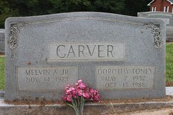
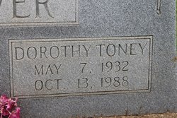
Dorothy Joyce Toney Carver
| Birth | : | 7 May 1932 Rutherford County, North Carolina, USA |
| Death | : | 13 Oct 1988 Asheville, Buncombe County, North Carolina, USA |
| Burial | : | St. Mary's Churchyard, Cholsey, South Oxfordshire District, England |
| Coordinate | : | 51.5788078, -1.1589500 |
frequently asked questions (FAQ):
-
Where is Dorothy Joyce Toney Carver's memorial?
Dorothy Joyce Toney Carver's memorial is located at: St. Mary's Churchyard, Cholsey, South Oxfordshire District, England.
-
When did Dorothy Joyce Toney Carver death?
Dorothy Joyce Toney Carver death on 13 Oct 1988 in Asheville, Buncombe County, North Carolina, USA
-
Where are the coordinates of the Dorothy Joyce Toney Carver's memorial?
Latitude: 51.5788078
Longitude: -1.1589500
Family Members:
Parent
Spouse

Siblings
Children
Flowers:

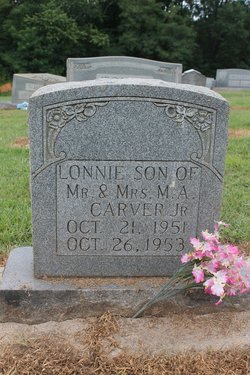
God Bless You. Julie, here.I want to say I Love You. Such a kind, warm, LOVING heart, You have ,and You always projected that.Especially to me. Thank-You for all the wonderful memories that You gave me.Uncle Mac,Lonnie,Paw-Paw,Grandmother Elsie,Daddy, and MOTHER are now in this beautiful garden with You.I know yal are so Joyful. I think maybe You and Mother are discussing "antiques" as Yal watch the sweet children playing!JESUS has All Yal in His care...until I can get to join Yal, just want You to KNOW YOU are LOVED and MISSED. Read less
Left by Anonymous on 05 Sep 2016
Happy Heavenly Birthday, a day late. So sorry. Love and miss you!!!!
Left by Anonymous on 08 May 2020

Happy Heavenly Birthday. God Bless You. Love, Julie
Left by Anonymous on 07 May 2022


Nearby Cemetories:
1. St. Mary's Churchyard
Cholsey, South Oxfordshire District, England
Coordinate: 51.5788078, -1.1589500
2. St. John the Baptist South Moreton
South Moreton, South Oxfordshire District, England
Coordinate: 51.5881630, -1.1895850
3. St. John the Baptist Church (Defunct)
Mongwell, South Oxfordshire District, England
Coordinate: 51.5860980, -1.1233580
4. St. Mary's Churchyard
North Stoke, South Oxfordshire District, England
Coordinate: 51.5714910, -1.1228080
5. South Moreton Strict Baptist Chapel
South Moreton, South Oxfordshire District, England
Coordinate: 51.5900300, -1.1924310
6. St Michael's Cemetery
Aston Tirrold, South Oxfordshire District, England
Coordinate: 51.5730994, -1.1967145
7. St John the Baptist
Moulsford, South Oxfordshire District, England
Coordinate: 51.5531050, -1.1482640
8. All Saints Churchyard
Aston Upthorpe, South Oxfordshire District, England
Coordinate: 51.5715900, -1.2037500
9. St. Leonard's Churchyard
Wallingford, South Oxfordshire District, England
Coordinate: 51.5972711, -1.1230712
10. St. Mary-le-More Churchyard
Wallingford, South Oxfordshire District, England
Coordinate: 51.5993878, -1.1249488
11. All Saints Churchyard
North Moreton, South Oxfordshire District, England
Coordinate: 51.6021922, -1.1898247
12. All Hallows Graveyard
Wallingford, South Oxfordshire District, England
Coordinate: 51.6020520, -1.1242267
13. Saint Peter's Churchyard
Wallingford, South Oxfordshire District, England
Coordinate: 51.6005819, -1.1215970
14. Saint James Churchyard
Brightwell cum Sotwell, South Oxfordshire District, England
Coordinate: 51.6120200, -1.1549800
15. St Andrew Churchyard
South Stoke, South Oxfordshire District, England
Coordinate: 51.5479065, -1.1377167
16. St Mary Magdalene Churchyard
Crowmarsh Gifford, South Oxfordshire District, England
Coordinate: 51.5992169, -1.1139564
17. St. Agatha New Churchyard
Brightwell cum Sotwell, South Oxfordshire District, England
Coordinate: 51.6131480, -1.1665480
18. Wallingford Cemetery
Wallingford, South Oxfordshire District, England
Coordinate: 51.6058200, -1.1232000
19. St. Mary the Virgin Cemetery
Ipsden, South Oxfordshire District, England
Coordinate: 51.5674164, -1.0866686
20. St. Michael Churchyard
Blewbury, Vale of White Horse District, England
Coordinate: 51.5693100, -1.2346100
21. St. Helen's Churchyard
Benson, South Oxfordshire District, England
Coordinate: 51.6200200, -1.1127400
22. St. Helen Churchyard Extension
Benson, South Oxfordshire District, England
Coordinate: 51.6201400, -1.1121200
23. Benson War Memorial
Benson, South Oxfordshire District, England
Coordinate: 51.6207890, -1.1108700
24. St Andrew's Church
East Hagbourne, South Oxfordshire District, England
Coordinate: 51.5901700, -1.2427700