
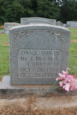
Melvin Alonzo “Lonnie” Carver
| Birth | : | 21 Oct 1951 Rutherford County, North Carolina, USA |
| Death | : | 26 Oct 1953 Charlotte, Mecklenburg County, North Carolina, USA |
| Burial | : | St. Mary's Churchyard, Cholsey, South Oxfordshire District, England |
| Coordinate | : | 51.5788078, -1.1589500 |
| Description | : | North Carolina, Death Certificates, 1909-1975 Name: Melvin Alanso Carver Gender: Male Race: White Age: 2 Birth Date: 21 Oct 1951 Birth Place: Rhherford, North Carolina, United States Death Date: 26 Oct 1953 Death Location: Charlotte, Mecklenburg Father's Name: Melvin Alonso Carver Residence: Charlotte, Mecklenburg, North Carolina |
frequently asked questions (FAQ):
-
Where is Melvin Alonzo “Lonnie” Carver's memorial?
Melvin Alonzo “Lonnie” Carver's memorial is located at: St. Mary's Churchyard, Cholsey, South Oxfordshire District, England.
-
When did Melvin Alonzo “Lonnie” Carver death?
Melvin Alonzo “Lonnie” Carver death on 26 Oct 1953 in Charlotte, Mecklenburg County, North Carolina, USA
-
Where are the coordinates of the Melvin Alonzo “Lonnie” Carver's memorial?
Latitude: 51.5788078
Longitude: -1.1589500
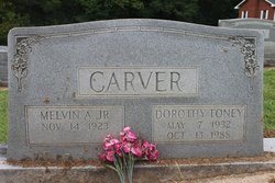
Family Members:
Parent
Flowers:

God Bless Your Little Sweet Heart!
Left by Anonymous on 05 Sep 2016

Happy Heavenly Birthday cousin, love, Julie. You were held closely and forever in the hearts of your Mom and Dad. Now you are together in heaven with Jesus. Amen! ( This note is one day late for your birthday, sorry)
Left by Anonymous on 22 Oct 2020
Happy Heavenly Birthday. God bless your sweet precious little heart . Love, Julie
Left by Anonymous on 21 Oct 2021


Nearby Cemetories:
1. St. Mary's Churchyard
Cholsey, South Oxfordshire District, England
Coordinate: 51.5788078, -1.1589500
2. St. John the Baptist South Moreton
South Moreton, South Oxfordshire District, England
Coordinate: 51.5881630, -1.1895850
3. St. John the Baptist Church (Defunct)
Mongwell, South Oxfordshire District, England
Coordinate: 51.5860980, -1.1233580
4. St. Mary's Churchyard
North Stoke, South Oxfordshire District, England
Coordinate: 51.5714910, -1.1228080
5. South Moreton Strict Baptist Chapel
South Moreton, South Oxfordshire District, England
Coordinate: 51.5900300, -1.1924310
6. St Michael's Cemetery
Aston Tirrold, South Oxfordshire District, England
Coordinate: 51.5730994, -1.1967145
7. St John the Baptist
Moulsford, South Oxfordshire District, England
Coordinate: 51.5531050, -1.1482640
8. All Saints Churchyard
Aston Upthorpe, South Oxfordshire District, England
Coordinate: 51.5715900, -1.2037500
9. St. Leonard's Churchyard
Wallingford, South Oxfordshire District, England
Coordinate: 51.5972711, -1.1230712
10. St. Mary-le-More Churchyard
Wallingford, South Oxfordshire District, England
Coordinate: 51.5993878, -1.1249488
11. All Saints Churchyard
North Moreton, South Oxfordshire District, England
Coordinate: 51.6021922, -1.1898247
12. All Hallows Graveyard
Wallingford, South Oxfordshire District, England
Coordinate: 51.6020520, -1.1242267
13. Saint Peter's Churchyard
Wallingford, South Oxfordshire District, England
Coordinate: 51.6005819, -1.1215970
14. Saint James Churchyard
Brightwell cum Sotwell, South Oxfordshire District, England
Coordinate: 51.6120200, -1.1549800
15. St Andrew Churchyard
South Stoke, South Oxfordshire District, England
Coordinate: 51.5479065, -1.1377167
16. St Mary Magdalene Churchyard
Crowmarsh Gifford, South Oxfordshire District, England
Coordinate: 51.5992169, -1.1139564
17. St. Agatha New Churchyard
Brightwell cum Sotwell, South Oxfordshire District, England
Coordinate: 51.6131480, -1.1665480
18. Wallingford Cemetery
Wallingford, South Oxfordshire District, England
Coordinate: 51.6058200, -1.1232000
19. St. Mary the Virgin Cemetery
Ipsden, South Oxfordshire District, England
Coordinate: 51.5674164, -1.0866686
20. St. Michael Churchyard
Blewbury, Vale of White Horse District, England
Coordinate: 51.5693100, -1.2346100
21. St. Helen's Churchyard
Benson, South Oxfordshire District, England
Coordinate: 51.6200200, -1.1127400
22. St. Helen Churchyard Extension
Benson, South Oxfordshire District, England
Coordinate: 51.6201400, -1.1121200
23. Benson War Memorial
Benson, South Oxfordshire District, England
Coordinate: 51.6207890, -1.1108700
24. St Andrew's Church
East Hagbourne, South Oxfordshire District, England
Coordinate: 51.5901700, -1.2427700