
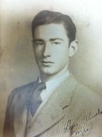
Melvin Alonzo “Mack” Carver Jr.
| Birth | : | 14 Nov 1923 Rutherford County, North Carolina, USA |
| Death | : | 21 Mar 2012 |
| Burial | : | St. Mary's Churchyard, Cholsey, South Oxfordshire District, England |
| Coordinate | : | 51.5788078, -1.1589500 |
frequently asked questions (FAQ):
-
Where is Melvin Alonzo “Mack” Carver Jr.'s memorial?
Melvin Alonzo “Mack” Carver Jr.'s memorial is located at: St. Mary's Churchyard, Cholsey, South Oxfordshire District, England.
-
When did Melvin Alonzo “Mack” Carver Jr. death?
Melvin Alonzo “Mack” Carver Jr. death on 21 Mar 2012 in
-
Where are the coordinates of the Melvin Alonzo “Mack” Carver Jr.'s memorial?
Latitude: 51.5788078
Longitude: -1.1589500
Family Members:
Parent
Spouse
Siblings
Children
Flowers:

Uncle Mac, Julie here. I Love You.Thank-You for being You. The kindness, gentleness,Reverentness,and all you represent. I can truly say, memories of visits in Your and Dot's home was ALWAYS a warm, genuine, fun and fond memory.See You in Heaven...when my journey is complete...as Jesus is guiding me along now, and not called me yet.LOVE,Julie Read less
Left by Anonymous on 05 Sep 2016
Happy Heavenly Birthday, 2 days late.God Bless You.Love and miss you. Julie.
Left by Anonymous on 16 Nov 2017

Happy Heavenly Birthday! God Bless You, love , Julie
Left by Anonymous on 14 Nov 2020
Happy Heavenly Birthday, uncle Mac. I love and miss you . Always was a joy to visit you and Dot and listen and learn of olden times and family. Hot coffee , slice of pie or cookies ... y'all shared. Thank you for the Godly man you were. Love, julie
Left by Anonymous on 14 Nov 2021


Nearby Cemetories:
1. St. Mary's Churchyard
Cholsey, South Oxfordshire District, England
Coordinate: 51.5788078, -1.1589500
2. St. John the Baptist South Moreton
South Moreton, South Oxfordshire District, England
Coordinate: 51.5881630, -1.1895850
3. St. John the Baptist Church (Defunct)
Mongwell, South Oxfordshire District, England
Coordinate: 51.5860980, -1.1233580
4. St. Mary's Churchyard
North Stoke, South Oxfordshire District, England
Coordinate: 51.5714910, -1.1228080
5. South Moreton Strict Baptist Chapel
South Moreton, South Oxfordshire District, England
Coordinate: 51.5900300, -1.1924310
6. St Michael's Cemetery
Aston Tirrold, South Oxfordshire District, England
Coordinate: 51.5730994, -1.1967145
7. St John the Baptist
Moulsford, South Oxfordshire District, England
Coordinate: 51.5531050, -1.1482640
8. All Saints Churchyard
Aston Upthorpe, South Oxfordshire District, England
Coordinate: 51.5715900, -1.2037500
9. St. Leonard's Churchyard
Wallingford, South Oxfordshire District, England
Coordinate: 51.5972711, -1.1230712
10. St. Mary-le-More Churchyard
Wallingford, South Oxfordshire District, England
Coordinate: 51.5993878, -1.1249488
11. All Saints Churchyard
North Moreton, South Oxfordshire District, England
Coordinate: 51.6021922, -1.1898247
12. All Hallows Graveyard
Wallingford, South Oxfordshire District, England
Coordinate: 51.6020520, -1.1242267
13. Saint Peter's Churchyard
Wallingford, South Oxfordshire District, England
Coordinate: 51.6005819, -1.1215970
14. Saint James Churchyard
Brightwell cum Sotwell, South Oxfordshire District, England
Coordinate: 51.6120200, -1.1549800
15. St Andrew Churchyard
South Stoke, South Oxfordshire District, England
Coordinate: 51.5479065, -1.1377167
16. St Mary Magdalene Churchyard
Crowmarsh Gifford, South Oxfordshire District, England
Coordinate: 51.5992169, -1.1139564
17. St. Agatha New Churchyard
Brightwell cum Sotwell, South Oxfordshire District, England
Coordinate: 51.6131480, -1.1665480
18. Wallingford Cemetery
Wallingford, South Oxfordshire District, England
Coordinate: 51.6058200, -1.1232000
19. St. Mary the Virgin Cemetery
Ipsden, South Oxfordshire District, England
Coordinate: 51.5674164, -1.0866686
20. St. Michael Churchyard
Blewbury, Vale of White Horse District, England
Coordinate: 51.5693100, -1.2346100
21. St. Helen's Churchyard
Benson, South Oxfordshire District, England
Coordinate: 51.6200200, -1.1127400
22. St. Helen Churchyard Extension
Benson, South Oxfordshire District, England
Coordinate: 51.6201400, -1.1121200
23. Benson War Memorial
Benson, South Oxfordshire District, England
Coordinate: 51.6207890, -1.1108700
24. St Andrew's Church
East Hagbourne, South Oxfordshire District, England
Coordinate: 51.5901700, -1.2427700